Jessie, North Dakota facts for kids
Quick facts for kids
Jessie, North Dakota
|
|
|---|---|

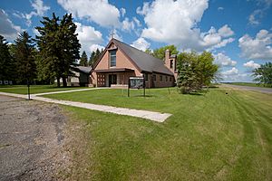
St. Lawrence Church in Jessie
|
|
| Country | United States |
| State | North Dakota |
| County | Griggs |
| Area | |
| • Total | 0.47 sq mi (1.23 km2) |
| • Land | 0.47 sq mi (1.23 km2) |
| • Water | 0.00 sq mi (0.00 km2) |
| Elevation | 1,450 ft (440 m) |
| Population
(2020)
|
|
| • Total | 22 |
| • Density | 46.32/sq mi (17.90/km2) |
| Time zone | UTC-6 (Central (CST)) |
| • Summer (DST) | UTC-5 (CDT) |
| ZIP codes |
58452
|
| Area code(s) | 701 |
| FIPS code | 38-40740 |
| GNIS feature ID | 2584348 |
Jessie is a small community located in northern Griggs County, North Dakota, in the United States. It is known as a census-designated place, which means it's an area identified by the U.S. Census Bureau for gathering population data, even though it's not an officially incorporated town or city.
This community was first recognized for census purposes on March 31, 2010. While it wasn't counted separately in the 2000 Census, it was included in the 2010 Census, which reported a population of 25 people. Jessie is situated along North Dakota Highway 65, a bit northwest of Cooperstown, which is the main town and county seat for Griggs County.
Population Information
This section shares details about the number of people living in Jessie. This kind of information is called demographics, which helps us understand a community's population.
According to the 2020 Census, Jessie had a population of 22 people. This shows a slight change from the 25 people counted in the 2010 Census.
See also
 In Spanish: Jessie (Dakota del Norte) para niños
 | Delilah Pierce |
 | Gordon Parks |
 | Augusta Savage |
 | Charles Ethan Porter |


