Jet, Oklahoma facts for kids
Quick facts for kids
Jet, Oklahoma
|
|
|---|---|

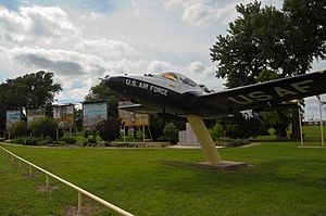
Cessna T-37B Tweet (serial # 56-3563) on display at the Jet Lions Memorial Park.
|
|
| Motto(s):
Goose Hunting Capital of Oklahoma
|
|

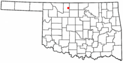
Location of Jet, Oklahoma
|
|
| Country | United States |
| State | Oklahoma |
| County | Alfalfa |
| Area | |
| • Total | 0.27 sq mi (0.70 km2) |
| • Land | 0.27 sq mi (0.70 km2) |
| • Water | 0.00 sq mi (0.00 km2) |
| Elevation | 1,243 ft (379 m) |
| Population
(2020)
|
|
| • Total | 197 |
| • Density | 724.26/sq mi (279.91/km2) |
| Time zone | UTC-6 (Central (CST)) |
| • Summer (DST) | UTC-5 (CDT) |
| ZIP code |
73749
|
| Area code(s) | 580 |
| FIPS code | 40-38000 |
| GNIS feature ID | 2412805 |
Jet is a small town located in the southeastern part of Alfalfa County, in the state of Oklahoma, United States. In 2020, about 197 people lived there.
Contents
History of Jet
The town of Jet was started by six brothers named Jett: Joseph, Trigg, Newt, Warner, John, and Richard. They were all unmarried. They built homes and started a general store on Richard's land. This happened in an area called the Cherokee Outlet, which was opened for new settlers.
The Jet post office opened in 1894. It moved from a nearby place called Barrel Springs. Warner Jett was the first postmaster. The community grew and officially became a town in 1900.
Around 1905-1906, the town of Jet moved about 2 miles (3.2 km) west. This move was because of a railroad company called the Denver, Enid and Gulf Railroad. By 1907, Jet had several churches, stores, banks, hotels, and a school. When Oklahoma became a state in 1907, Jet had 213 people.
Where is Jet Located?
Jet is about 12 miles (19 km) east-southeast of Cherokee, which is the county seat.
The town is found where two main roads meet: U.S. Highway 64 and State Highway 38. Highway 38 ends right at this intersection.
The United States Census Bureau says that Jet covers about 0.3 square miles (0.78 square kilometers) of land. There is no water area within the town limits.
Jet's Climate
| Climate data for Jet, Oklahoma | |||||||||||||
|---|---|---|---|---|---|---|---|---|---|---|---|---|---|
| Month | Jan | Feb | Mar | Apr | May | Jun | Jul | Aug | Sep | Oct | Nov | Dec | Year |
| Mean daily maximum °F (°C) | 43.8 (6.6) |
49.8 (9.9) |
59.9 (15.5) |
70.7 (21.5) |
79.5 (26.4) |
89.5 (31.9) |
95.9 (35.5) |
93.8 (34.3) |
84.3 (29.1) |
73.6 (23.1) |
58.4 (14.7) |
46.9 (8.3) |
70.5 (21.4) |
| Mean daily minimum °F (°C) | 20.1 (−6.6) |
25.2 (−3.8) |
34.1 (1.2) |
46.1 (7.8) |
56.0 (13.3) |
65.0 (18.3) |
70.0 (21.1) |
67.9 (19.9) |
59.9 (15.5) |
47.4 (8.6) |
35.0 (1.7) |
24.4 (−4.2) |
45.9 (7.7) |
| Average precipitation inches (mm) | 0.7 (18) |
1.0 (25) |
2.4 (61) |
2.7 (69) |
3.9 (99) |
3.5 (89) |
2.7 (69) |
3.3 (84) |
3.3 (84) |
2.1 (53) |
1.8 (46) |
0.8 (20) |
28.1 (710) |
| Source 1: weather.com | |||||||||||||
| Source 2: Weatherbase.com | |||||||||||||
People in Jet
| Historical population | |||
|---|---|---|---|
| Census | Pop. | %± | |
| 1910 | 365 | — | |
| 1920 | 370 | 1.4% | |
| 1930 | 389 | 5.1% | |
| 1940 | 442 | 13.6% | |
| 1950 | 371 | −16.1% | |
| 1960 | 339 | −8.6% | |
| 1970 | 317 | −6.5% | |
| 1980 | 352 | 11.0% | |
| 1990 | 272 | −22.7% | |
| 2000 | 230 | −15.4% | |
| 2010 | 213 | −7.4% | |
| 2020 | 197 | −7.5% | |
| U.S. Decennial Census | |||
In 2000, there were 230 people living in Jet. There were 115 households, which are groups of people living together. About 71 of these were families.
The average household had 2 people. The average family had about 2.57 people.
The population was spread out by age:
- 16.5% were under 18 years old.
- 3.0% were between 18 and 24.
- 24.3% were between 25 and 44.
- 26.1% were between 45 and 64.
- 30.0% were 65 years or older.
The median age in the town was 50 years. This means half the people were younger than 50 and half were older.
Jet's Economy
Jet's economy has always been based on farming. The main things produced here are wheat, livestock (like cows and pigs), and poultry (like chickens).
Tourism also helps the town's economy. This started when the Great Salt Plains National Wildlife Refuge was created in 1930. Jet is also the closest town to Great Salt Plains Lake and Great Salt Plains State Park. These places are popular for visitors.
Education in Jet
Jet-Nash High School used to serve the town until 2013. It closed because it didn't have enough money.
Now, Jet is part of the Timberlake Regional School District. This district also includes the towns of Nash, Nescatunga, Goltry, and Helena.
The elementary school for the district is in Jet. It's in the building that used to be Jet-Nash High School. The high school, Timberlake High School, is located in Helena, which is about 13 miles (21 km) south of Jet.
See also
 In Spanish: Jet (Oklahoma) para niños
 | Lonnie Johnson |
 | Granville Woods |
 | Lewis Howard Latimer |
 | James West |

