Jiwani facts for kids
Quick facts for kids
Jiwani
جيونى
|
|
|---|---|
|
City
|
|

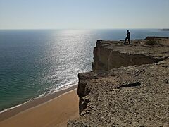
Darah Beach, Pakistan
|
|
| Country | |
| Province | Balochistan |
| Population
(2023)
|
|
| • Total | 25,332 |
| Time zone | UTC+5 (PST) |
| Postal code |
91100
|
Jiwani is a town and port city in Pakistan. It is located in the Gwadar District of the Balochistan province. Jiwani sits right on the Gulf of Oman, close to the border with Iran.
This town is home to about 25,000 people. It is becoming an important place for trade. Jiwani is about 60 kilometers (37 miles) from Gwadar, another port city. It is also about 115 kilometers (71 miles) from Chabahar in Iran.
Contents
Discovering Jiwani
Jiwani is located between the cities of Gwadar and Chabahar. It sits at the eastern end of the Gwadar Bay. This area is special because it has a large mangrove forest. Mangroves are unique trees that grow in salty water.
The bay is also a home for many animals. It is especially important for two types of sea turtles: the olive ridley and the green turtles. These turtles are endangered, meaning they are at risk of disappearing forever.
Most people in Jiwani make their living by fishing. There are also several factories that freeze fish for export. Jiwani is only 34 kilometers (21 miles) from the Iranian border.
Jiwani's Important Location
Jiwani is very important because of where it is located. It is right next to the shipping routes that lead to and from the Persian Gulf. This is why Jiwani has a small naval base. A naval base is a place where military ships are kept.
The town also has an airport with a runway that is about 1,676 meters (5,500 feet) long. This airport was used during World War II by the Allied forces. You can still see parts of the old airfields today.
If you visit the old airfield, you might find small stories and names written by pilots from World War II. There was also a clever water system built back then. It collected rainwater in three steps to clean it. The clean water was then sent to the airfield and other buildings.
Today, the Makran Coastal Highway connects Jiwani to Gwadar and Karachi. This makes it easier to travel to and from the town.
How Many People Live in Jiwani?
The number of people living in Jiwani has grown a lot over the years. In 1972, there were about 5,350 people. By 2023, the population had grown to 25,332!
| Census | Population |
|---|---|
| 1972 | 5,350 |
| 1998 | 14,072 |
| 2017 | 18,268 |
| 2023 | 25,332 |
Jiwani Military Base
There have been reports that Pakistan and China are planning to build a military base in Jiwani. This shows how important Jiwani's location is for defense and security.
Jiwani's Weather
Jiwani has a hot desert climate. This means it is usually hot and dry. Summers are very hot and humid, but they don't get much rain. Winters are warm.
Most of the rain in Jiwani falls during the winter months. Sometimes, there is a little rain during the monsoon season in July and August.
| Climate data for Jiwani (1991-2020) | |||||||||||||
|---|---|---|---|---|---|---|---|---|---|---|---|---|---|
| Month | Jan | Feb | Mar | Apr | May | Jun | Jul | Aug | Sep | Oct | Nov | Dec | Year |
| Record high °C (°F) | 31.1 (88.0) |
33.0 (91.4) |
39.0 (102.2) |
40.5 (104.9) |
45.0 (113.0) |
48.0 (118.4) |
42.5 (108.5) |
39.5 (103.1) |
41.1 (106.0) |
40.5 (104.9) |
37.2 (99.0) |
31.1 (88.0) |
48.0 (118.4) |
| Mean daily maximum °C (°F) | 24.5 (76.1) |
25.9 (78.6) |
28.7 (83.7) |
32.5 (90.5) |
34.9 (94.8) |
34.6 (94.3) |
32.6 (90.7) |
31.6 (88.9) |
31.9 (89.4) |
33.0 (91.4) |
30.1 (86.2) |
26.5 (79.7) |
30.6 (87.0) |
| Daily mean °C (°F) | 19.2 (66.6) |
20.6 (69.1) |
23.5 (74.3) |
27.0 (80.6) |
30.0 (86.0) |
30.6 (87.1) |
29.5 (85.1) |
28.5 (83.3) |
28.2 (82.8) |
27.6 (81.7) |
24.2 (75.6) |
20.7 (69.3) |
25.8 (78.5) |
| Mean daily minimum °C (°F) | 13.9 (57.0) |
15.3 (59.5) |
18.3 (64.9) |
22.0 (71.6) |
25.2 (77.4) |
26.6 (79.9) |
26.4 (79.5) |
25.5 (77.9) |
24.5 (76.1) |
22.2 (72.0) |
18.3 (64.9) |
14.8 (58.6) |
21.1 (69.9) |
| Record low °C (°F) | 3.9 (39.0) |
6.0 (42.8) |
5.5 (41.9) |
15.6 (60.1) |
19.0 (66.2) |
22.8 (73.0) |
21.5 (70.7) |
21.7 (71.1) |
18.3 (64.9) |
13.0 (55.4) |
5.6 (42.1) |
3.9 (39.0) |
3.9 (39.0) |
| Average precipitation mm (inches) | 21.2 (0.83) |
4.9 (0.19) |
16.4 (0.65) |
6.7 (0.26) |
0.0 (0.0) |
9.8 (0.39) |
3.1 (0.12) |
1.5 (0.06) |
0.0 (0.0) |
1.3 (0.05) |
3.1 (0.12) |
15.4 (0.61) |
83.4 (3.28) |
| Average precipitation days (≥ 1.0 mm) | 1.9 | 0.6 | 0.8 | 0.2 | 0.0 | 0.2 | 0.4 | 0.3 | 0.0 | 0.1 | 0.3 | 1.2 | 6 |
| Mean monthly sunshine hours | 273.0 | 254.1 | 281.1 | 287.9 | 332.0 | 280.5 | 214.2 | 206.7 | 254.3 | 307.5 | 294.2 | 272.3 | 3,257.8 |
| Source: NOAA (extremes, sun 1961-1990) | |||||||||||||


