Joaquín Suárez (town) facts for kids
Quick facts for kids
Joaquín Suárez
|
|
|---|---|
|
Village
|
|
 |
|
| Country | |
| Department | Canelones Department |
| Founded | 1882 |
| Population
(2011)
|
|
| • Total | 6,570 |
| Time zone | UTC -3 |
| Postal code |
91200
|
| Dial plan | +598 2 (+7 digits) |
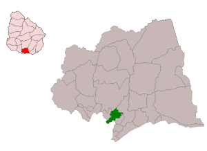
Joaquín Suárez is a village located in the Canelones Department of southern Uruguay. It's also the name of the larger area (municipality) that the village is part of. You can find it where Routes 84 and 74 meet. It's northeast of Toledo and southwest of Pando. Another town called Sauce is about 10 kilometers (about 6 miles) north. All these villages are considered part of the bigger city area around Montevideo.
Contents
A Look Back: The History of Joaquín Suárez
Joaquín Suárez is named after a very important person: the president of Uruguay from 1843 to 1852. The idea to create a town in this spot was officially approved on July 21, 1866. The town was actually started on October 15, 1882, by a person named Francisco Piria. Later, on October 2, 1929, it was officially declared a "pueblo," which means a village, by a special law.
Community Life: Places of Worship
In Joaquín Suárez, there are places where people gather for religious services.
- The Parish Church of St. Francis of Assisi is a Roman Catholic church. It is run by the Dominican Sisters of the Presentation.
How Many People Live Here?
In 2011, the village of Joaquín Suárez had a population of 6,570 people. The number of people living in the village has grown a lot over the years.
The table below shows how the population has changed over time:
| Year | Population |
|---|---|
| 1908 | 1,425 |
| 1963 | 2,357 |
| 1975 | 3,458 |
| 1985 | 4,175 |
| 1996 | 5,173 |
| 2004 | 6,214 |
| 2011 | 6,570 |
This information comes from the Instituto Nacional de Estadística de Uruguay, which is Uruguay's national statistics office.
Want to Learn More?
- In Spanish: Joaquín Suárez (ciudad) para niños
 | Isaac Myers |
 | D. Hamilton Jackson |
 | A. Philip Randolph |


