Johnson Mesa facts for kids
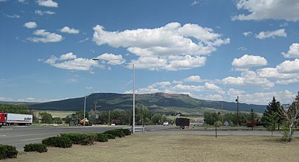
Johnson Mesa is a really big, flat-topped hill called a mesa. It's located in northeastern New Mexico, close to the Colorado border. The city of Raton is to its west, and the town of Folsom is to its east.
What is Johnson Mesa Like?
Johnson Mesa is about 14 miles (23 km) long from east to west. It's also between 2 miles (3 km) and 6 miles (10 km) wide from north to south. This huge, flat area is covered with old lava rock. It gently slopes downwards from 8,650 feet (2,637 m) on the west side to 7,600 feet (2,316 m) on the east.
The sides of the Mesa are very steep cliffs. These cliffs can be anywhere from 500 feet (152 m) to 1,900 feet (579 m) high! From the top of Johnson Mesa, you can see amazing views of the Great Plains far below.
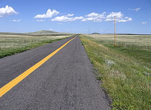
New Mexico Highway 72 crosses the Mesa from east to west. This road is part of a special route called the Dry Cimarron State Scenic & Historic Byway. On top of the Mesa, you'll find a few old volcanoes. These include Red Mountain, Towndrow Peak, and Dale Mountain. They rise about 400 feet (122 m) above the mostly flat and open land.
The cliffs around the Mesa have trees like pinyon, juniper, Gambel oak, and ponderosa pine. But the top of the Mesa is mostly open grassland. The Dry Cimarron River starts on the Mesa. Before settlers arrived, the only water came from puddles after it rained. Now, there are a few small lakes and ponds, like Berry and Bellisle lakes, which were made for cattle.
Just below the south side of Johnson Mesa is an area called Johnson Park. It's about 3 miles (5 km) by 2 miles (3 km) and sits at 6,800 feet (2,073 m) high. This park was the first way people could get up to the Mesa.
Because it's so high up, summers on Johnson Mesa are cooler. But winters can be very cold and windy. The Mesa gets about 18 inches (457 mm) of rain and snow each year, similar to nearby Raton.
History of Johnson Mesa
Scientists haven't found any signs that Native Americans lived on Johnson Mesa itself. However, just below the eastern edge of the Mesa, at a place called the Folsom Site, some of the oldest evidence of early humans in North America was discovered!
The first white settler to the area was Elijah (Lige) Johnson. Around 1882, he started a ranch in Johnson Park and let his cattle graze on the Mesa. Letting cattle graze on top of mesas was a common practice in northern New Mexico. Some mesas are still called potreros today, which means "pasture" in Spanish.
Around 1887, a railway worker named Marion Bell led a group of unhappy railroad workers and coal miners to the Mesa. They started claiming free land there under the Homestead Act. Soon, the entire Mesa was filled with homesteads, each with 160 acres (65 hectares) of free land.
The community of Bell, on Johnson Mesa, had its largest population around 1900, with 487 people. Bell had a Methodist church and a cemetery. There were also five schools spread across the Mesa. The people living there would celebrate July 4th and August 14th (the day the church was dedicated) every year.
The rich volcanic soil on the Mesa was great for growing crops. Farmers mainly grew oats, potatoes, vegetables, and hay. Many men worked as both farmers and coal miners. Sometimes, carrier pigeons were used to send messages from the mines to the Mesa when more workers were needed.
However, the long, cold winters made farming very difficult for many people. By 1910, the population had dropped to 335. After a sickness spread in 1920, it was only 215. By 1950, only 56 people lived there. The Post Office in Bell closed in 1933.
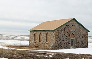
In the early 2000s, no one lived on Johnson Mesa all year round. Some ranchers still spent their summers there taking care of their cattle. Today, the only things left of the old community of Bell are a cemetery and St. John's Methodist Episcopal Church, which was built in 1897.
 | Stephanie Wilson |
 | Charles Bolden |
 | Ronald McNair |
 | Frederick D. Gregory |


