Jones Falls facts for kids
Quick facts for kids Jones Falls |
|
|---|---|

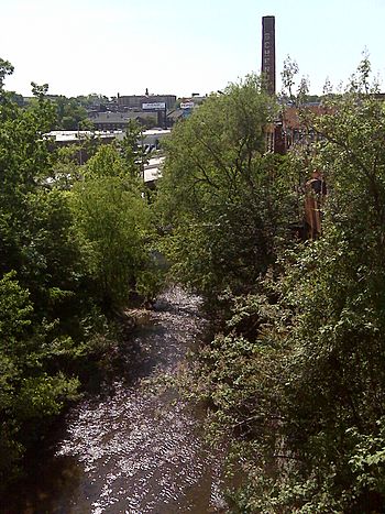
A view of the Jones Falls from the 41st Street bridge, which crosses the valley. The JFX (Jones-Falls Expressway) is also visible in the center of the picture.
|
|

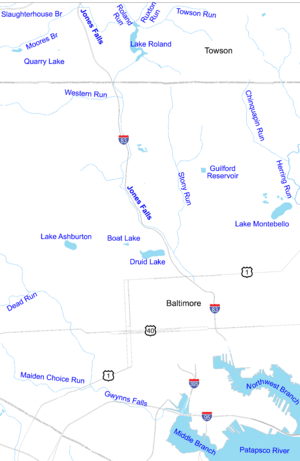
A map of the Jones Falls watershed in Baltimore
|
|
| Country | United States |
| State | Maryland |
| City | Baltimore |
| Physical characteristics | |
| River mouth | Baltimore Inner Harbor Baltimore, Maryland, United States |
| Basin features | |
| Tributaries |
|
The Jones Falls is a stream in Maryland that is about 17.9 miles (28.8 km) long. It flows through Baltimore County and the city of Baltimore. The stream eventually empties into the Baltimore Inner Harbor.
The valley where the Jones Falls flows has been important for transportation for a long time. It carries several major routes. These include Falls Road (also known as Maryland Route 25), tracks for Amtrak Northeast Corridor trains, and the Jones Falls Expressway (JFX). The Baltimore Light Rail also runs through the valley. Even Baltimore Penn Station, a major train station, is built on a raised platform in the valley.
Journey of the Jones Falls Stream
The Jones Falls starts as a small stream in Baltimore County. This is near a place called Garrison. It flows southeast for about 3.3 miles (5.3 km). Then, it meets another stream called the North Branch Jones Falls.
Where the North Branch Begins
The North Branch Jones Falls starts near Worthington. It flows south for about 5.2 miles (8.4 km). This branch then joins the main Jones Falls stream.
Streams Joining the Jones Falls
After the North Branch joins, the Jones Falls continues its journey. It flows east for about 1.3 miles (2.1 km). Here, a stream called Dipping Pond Run adds its water. The Jones Falls then goes another 0.8 miles (1.3 km) east. At this point, Deep Run flows into it near Brooklandville.
Flowing Alongside the Expressway
The stream then turns south. It flows alongside Interstate 83 (I-83), which is called the Jones Falls Expressway. This stretch is about 1.7 miles (2.7 km) long. Along this path, two more streams, Slaughterhouse Branch and Moores Branch, join the Jones Falls.
Reaching Lake Roland
The Jones Falls continues southeast for about 1.5 miles (2.4 km). It passes through Lake Roland Park. Then, it reaches Lake Roland, which is a lake formed by damming the stream. In Lake Roland, two other streams, Roland Run and Towson Run, join the Jones Falls. After leaving Lake Roland, the Jones Falls becomes a small river.
Entering Baltimore City
Soon after leaving Lake Roland, the Jones Falls enters Baltimore city. It flows directly under where Interstate 83 and the Baltimore Light Rail cross. Both the highway and the light rail tracks then run next to the river. For the rest of its path, I-83 often crosses over, runs next to, or even covers the river.
More Streams Join in the City
About half a mile after entering the city, Western Run joins the Jones Falls near Mount Washington. The Jones Falls, I-83, and the Light Rail continue south for 4.4 miles (7.1 km). The last major stream, Stony Run, flows into the Jones Falls near Druid Hill Park. Along this part of the journey, Maryland Route 25 (Falls Road) also enters the valley. It runs parallel to the river, on the opposite side from the highway and rail lines. The Jones Falls Trail, a popular path, also runs next to MD 25. About a quarter mile before Stony Run, the Jones Falls flows over a ten-foot waterfall called "Round Falls."
The Final Stretch to the Harbor
About 0.6 miles (1 km) after Stony Run, the Jones Falls passes the Baltimore Streetcar Museum. Then, the CSXT-operated Baltimore Belt Line train tracks cross over the river. The Jones Falls immediately flows under North Avenue. Just south of North Avenue, the Amtrak Northeast Corridor train tracks enter the valley. They come out of the Baltimore and Potomac Tunnel and cross the Jones Falls. The Howard Street Bridge is directly above this crossing.
Entering the Conduit
MD 25 ends shortly after this point. The Jones Falls Trail joins city streets, and the Light Rail also leaves the valley. After many bridges, the Jones Falls quickly enters a tunnel. This tunnel is called the Jones Falls Conduit. It curves to flow directly underneath I-83. The river and highway continue to Fayette Street. Here, I-83 ends. Two blocks south of this point, the Jones Falls leaves the conduit. It flows a few more blocks before emptying into the east side of the Inner Harbor. This is near a cool invention called Mr. Trash Wheel.
Future Plans for the Jones Falls
For many years, people have thought about changing the area around the Jones Falls. As far back as 1990, city studies suggested removing parts of I-83. This would allow the Jones Falls, which is currently underground in some places, to flow openly again. This process is called daylighting.
Long-Term Vision
One idea for the future is a big plan from Marc Szarkowski. His vision includes building new homes and expanding Penn Station. It also suggests new ways for traffic to flow and even new underground transit lines. Szarkowski knows that this plan is very ambitious and would take a long time to complete.
More Immediate Study
Another study was done in 2009 by a company called Rummel, Klepper & Kahl (RK&K). This study focused on a smaller area of the Jones Falls valley. It looked at the section from Fayette Street to Chase Street. While Szarkowski's idea covers a much larger area, the RK&K study provided more detailed engineering plans for its specific section.
 | Chris Smalls |
 | Fred Hampton |
 | Ralph Abernathy |


