Jordan Point, Virginia facts for kids
Quick facts for kids
Jordan Point
|
|
|---|---|

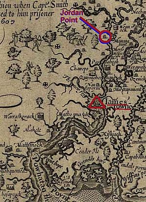
Location of Native American settlement at Jordan Point upstream from Jamestown on the James River circa 1607 (from Smith and Hole's 1624 map of Virginia).
|
|
| Country | United States |
| State | Virginia |
| County | Prince George |
| Elevation | 20 ft (6 m) |
| Time zone | UTC−5 (Eastern (EST)) |
| • Summer (DST) | UTC−4 (EDT) |
| GNIS feature ID | 1739904 |
Jordan Point (sometimes called Jordan's Point) is a small community in Prince George County, Virginia, United States. It's located on the south side of the James River. This spot is about 20 miles from Richmond and 30 miles upstream from Jamestown.
Between 1987 and 1993, scientists did a lot of digging and research here. They found out a great deal about human life in the area. Their discoveries covered everything from very old times (prehistoric) to the later colonial period. They especially learned a lot about a settlement called Jordan's Journey. This settlement existed between 1620 and 1640, during the early years of the Virginia colony.
Contents
Early Days of Jordan Point
English settlers first arrived at Jamestown in 1607. The land at Jordan's Point became known as "Jordan’s Journey" in 1619. At that time, it was part of Charles Cittie, an early area of the Virginia Company of London. This company was in charge of the Virginia Colony back then.
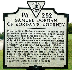
The first recorded owner was Samuel Jordan. He and his wife, Cecily, along with her two daughters and their adult male servants, moved there around 1620. Samuel Jordan passed away in 1623. His widow, Cecily, then married William Farrar, who also moved to Jordan’s Journey. The settlement seems to have been left empty by 1635.
In 1624, Virginia became a royal colony. This meant it was directly ruled by the King of England. Ten years later, in 1634, the Jordan's Point area became part of Charles City Shire. This later became Charles City County. In 1703, the part of Charles City County south of the James River became Prince George County.
Later, in 1656, Theodorick Bland bought the land at Jordan's Point. His son, Richard Bland (I), inherited it in 1671. Richard Bland built a home there, known as Jordan's Point Plantation, before he died in 1720.
Jordan Point's Role in Travel
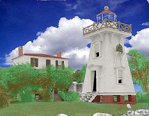
Jordan Point has always been important for travel. A Light Station was built there in 1855. Its job was to help guide ships safely up the James River.
Jordan Point was also a key place for crossing the James River. For a long time, it was the southern end of a ferry system. This ferry connected Prince George County with Charles City County on the north side of the river.
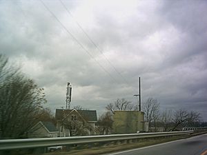
In 1966, the Benjamin Harrison Memorial Bridge was built. This large lift-span bridge took the place of the ferry system. Today, Jordan Point Road uses State Routes 106 and 156. These routes connect State Route 10 to the bridge.
In 1977, a large tanker ship called the S.S. Marine Floridian was sailing down the river. Its steering stopped working, and it crashed into the Benjamin Harrison Bridge. The crash destroyed two parts of the bridge and badly damaged the drawbridge. Because of this, the bridge was closed for 20 months. During that time, the ferry service had to be brought back temporarily.
Jordan Point Today
Jordan Point once had a small airport. It was built in the 1940s by Hummel Aviation and was called the Hopewell Airport. This airport was located on the same land as the historic Jordan's Journey settlement.
In 1987, the airport property was sold. Now, a neighborhood called "Jordan on the James" is built where the airport used to be. Jordan Point also had a golf course, but it closed in 2015.
Today, Jordan Point is home to the Jordan Point Marina. This marina is located on the James River, just north of the Benjamin Harrison Bridge. In 2003, Hurricane Isabel caused a huge storm surge that hit the marina. Over 100 boats and yachts were badly damaged or destroyed. Luckily, the marina has since been rebuilt and is open again.
Additional Resources
- Martha McCartney's (2011) book Jordan's Point, Virginia, Archaeology in Perspective, Prehistoric to Modern Times (ISBN: 9780615455402) gives a detailed look at the old things found at Jordan Point. It also shares a full history of the area.
- Catherine Alston's (2004) Artifact Images from Jordan's Journey shows color pictures of many items from 1620-1640 found at Jordan's Journey. (McCartney, 2011, explains why they are important).
- Catherine Alston's (2004) Artifact Distribution Maps from Jordan's Journey provides detailed maps of the Jordan Journey archaeological site. These maps show the layout of the Jordan-Farrar complex.
- Ivor Noël Humes (1979) National Geographic article First Look at a Lost Virginia Settlement mainly focuses on the Wolstenholme Towne site. However, it also includes pictures of what life was like in Virginia in the 1620s. These pictures are based on what archaeologists found.
 | Sharif Bey |
 | Hale Woodruff |
 | Richmond Barthé |
 | Purvis Young |


