Kachemak, Alaska facts for kids
Quick facts for kids
Kachemak
|
|
|---|---|
 |
|
| Country | United States |
| State | Alaska |
| Borough | Kenai Peninsula |
| Incorporated | August 29, 1961 |
| Area | |
| • Total | 1.67 sq mi (4.33 km2) |
| • Land | 1.67 sq mi (4.33 km2) |
| • Water | 0.00 sq mi (0.00 km2) |
| Elevation | 105 ft (32 m) |
| Population
(2020)
|
|
| • Total | 576 |
| • Density | 344.09/sq mi (132.89/km2) |
| Time zone | UTC-9 (Alaska (AKST)) |
| • Summer (DST) | UTC-8 (AKDT) |
| ZIP code |
99603
|
| Area code | 907 |
| FIPS code | 02-36540 |
| GNIS feature ID | 1413247 |
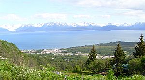
Kachemak, also known as Kachemak City, is a small city in Alaska, United States. It is located in the southern part of the Kenai Peninsula Borough. The city stretches for about 2 miles (3.2 km) along East End Road. It is right next to the larger city of Homer. In 2020, 576 people lived in Kachemak.
Where is Kachemak Located?
Kachemak is found in south-central Alaska. It is just east of Homer. The city sits on the north side of Kachemak Bay. The entire city covers about 1.6 square miles (4.3 square kilometers) of land. There is no water area within the city limits.
People of Kachemak
Kachemak first became an official city in 1961. The first time it appeared in the U.S. Census was in 1970. Back then, only 76 people lived there.
Here is how the population has grown over the years:
- 1970: 76 people
- 1980: 403 people
- 1990: 365 people
- 2000: 431 people
- 2010: 472 people
- 2020: 576 people
In 2000, there were 431 people living in Kachemak. Most people were White. Some residents were Native American or Asian. A small number of people were from other backgrounds.
About one-third of the homes in Kachemak had children under 18 living there. Many homes were families with married couples. The average household had about 2.5 people.
The median age in the city was 43 years old. This means half the people were older than 43 and half were younger. About 24% of the population was under 18 years old.
See also
 In Spanish: Kachemak (Alaska) para niños
 | William M. Jackson |
 | Juan E. Gilbert |
 | Neil deGrasse Tyson |


