
Kainuu facts for kids
Quick facts for kids
Kainuu
Kainuun maakunta
Kajanalands landskap |
|||
|---|---|---|---|
|
|||

Kainuu on a map of Finland
|
|||
| Country | Finland | ||
| Government | |||
| • Type | Region of Finland | ||
| Area | |||
| • Total | 22,687.38 km2 (8,759.65 sq mi) | ||
| Population | |||
| • Total | 75 415 | ||
| Time zone | UTC+2 (EET) | ||
| • Summer (DST) | UTC+3 (EEST) | ||
| ISO 3166 code | FI-05 | ||
| NUTS | 134 | ||
| Regional bird | Siberian jay (Perisoreus infaustus) | ||
| Regional fish | European smelt (Osmerus eperlanus) | ||
| Regional flower | Heather (Calluna vulgaris) | ||
| Regional Stone | Greenschist | ||
| Regional lake | Oulujärvi | ||
| Regional song | Nälkämaan laulu | ||
| Website | www.kainuu.fi | ||


Kainuu is a beautiful region located in eastern Finland. It's a place where about 75,000 people live, as of January 2015. This region shares borders with Northern Ostrobothnia, Northern Savonia, and North Karelia. Kainuu is known for its diverse culture and friendly communities.
Contents
Towns and Communities in Kainuu
Kainuu is made up of several local areas called municipalities. Two of these municipalities are big enough to be called cities. The numbers next to each name show how many people lived there at the time.
 Hyrynsalmi (2,432 people)
 Kuhmo (8,820 people)
 Puolanka (2,784 people)
 Suomussalmi (8,342 people)
 Kajaani (37,664 people)
 Paltamo (3,493 people)
 Ristijärvi (1,356 people)
 Sotkamo (10,524 people)
Changes in Kainuu's Municipalities
In early 2016, one municipality, Vaala, moved from Kainuu to the Northern Ostrobothnia region.
Images for kids
-
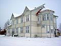
The Kajaani railway station
-
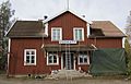
The Vuokatti railway station
-
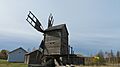
The windmill of Riihipiha in Vuolijoki


See also
 In Spanish: Región de Kainuu para niños

All content from Kiddle encyclopedia articles (including the article images and facts) can be freely used under Attribution-ShareAlike license, unless stated otherwise. Cite this article:
Kainuu Facts for Kids. Kiddle Encyclopedia.