
Kalbarri, Western Australia facts for kids
Quick facts for kids KalbarriWestern Australia |
|||||||||
|---|---|---|---|---|---|---|---|---|---|

Kalbarri Town
|
|||||||||

Kalbarri
Location in Western Australia
|
|||||||||
| Established | 1951 | ||||||||
| Postcode(s) | 6536 | ||||||||
| Elevation | 6 m (20 ft) | ||||||||
| Area | [convert: needs a number] | ||||||||
| Location | |||||||||
| LGA(s) | Shire of Northampton | ||||||||
| State electorate(s) | North West Central | ||||||||
| Federal Division(s) | Durack | ||||||||
|
|||||||||
Kalbarri is a pretty coastal town in the Mid West region of Western Australia. It's about 592 kilometers (368 miles) north of Perth. The town sits right where the Murchison River meets the ocean. You can get to Kalbarri from Perth using special bus services.
Kalbarri's Past
Kalbarri is part of the traditional lands of the Nanda people. They are the original owners of more than 17,000 square kilometers (6,564 square miles) of land and water. This area is in the Yamatji region of Western Australia. The Nanda people were officially recognized as traditional owners in 2018.
The Nanda people have special rights over important places. These include Paradise Flats, Bully, Wilgie Mia, Mooliabatanya, and Syphon pools.
The story of the Beemarra serpent is very important to the Nanda people. They believe the Beemarra is an ancient spirit. This spirit helped create the land and water in the Kalbarri area.
The town of Kalbarri was named after a Nanda Aboriginal man. It is also the name of a type of edible seed.
The tall cliffs near the river mouth got their name from a ship. A trading ship called the Zuytdorp crashed there in 1712.
In the 1940s, Kalbarri became a popular spot for fishing and holidays. By 1948, the government decided to make it an official town. Land was measured out, and the town was officially named in 1951.
In April 2021, a strong storm hit the town. This storm was called Tropical Cyclone Seroja. It caused a lot of damage to Kalbarri.
Fun Things to Do in Kalbarri
Kalbarri is a great place for tourists and fishing fans. There are many fun things to see and do. One popular activity is watching the daily pelican feeding.
You can also visit the amazing Kalbarri National Park. Here, you can explore the Murchison River Gorge and the Murchison River. There are even boat trips you can take on the river.
About 200,000 tourists visit Kalbarri every year. During school holidays, the town gets very busy. Its population can grow to 8,000 people! To help keep the lights on, the town has a large battery. This battery helps make sure there's enough electricity for everyone.
The Kalbarri National Park has some amazing natural sights. One is called the Z Bend, which is a lookout point. Another is "Nature's Window," a rock formation that looks like a window. It offers a great view of the Murchison River. South of town, you can see Red Bluff and other beautiful coastal cliffs.
The Rainbow Jungle, which was a parrot breeding center, was badly damaged by the 2021 cyclone. It is now closed for good.
-
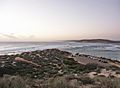
Murchison River mouth at sunset
-
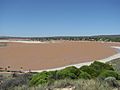
Murchison River after heavy rain


Kalbarri's Weather
Kalbarri has a hot, dry climate. This means it has very hot, dry summers. Its winters are very mild and sometimes rainy.
The average highest temperature in February is about 34.1 degrees Celsius (93.4°F). In July, the average highest temperature is around 21.9 degrees Celsius (71.4°F). The average lowest temperature in February is about 20.7 degrees Celsius (69.3°F). In July, it's around 9.7 degrees Celsius (49.5°F).
Kalbarri doesn't get much rain, averaging about 342.2 millimeters (13.5 inches) per year. Rain falls on about 62 days each year. On April 11, 2021, Cyclone Seroja hit the town. This caused a lot of damage and power cuts.
The town is very sunny. It has about 186 clear days each year. Only about 60 days are cloudy. The hottest temperature ever recorded was 48.1 degrees Celsius (118.6°F) in February 2024. The coldest was -1.3 degrees Celsius (29.7°F) in July 1979.
| Climate data for Kalbarri (27°43′S 114°10′E / 27.71°S 114.17°E, 6 m AMSL) (1970-2024 data) | |||||||||||||
|---|---|---|---|---|---|---|---|---|---|---|---|---|---|
| Month | Jan | Feb | Mar | Apr | May | Jun | Jul | Aug | Sep | Oct | Nov | Dec | Year |
| Record high °C (°F) | 46.4 (115.5) |
48.1 (118.6) |
47.2 (117.0) |
39.7 (103.5) |
36.2 (97.2) |
30.9 (87.6) |
30.5 (86.9) |
33.0 (91.4) |
38.5 (101.3) |
41.2 (106.2) |
42.4 (108.3) |
46.5 (115.7) |
48.1 (118.6) |
| Mean daily maximum °C (°F) | 33.2 (91.8) |
34.1 (93.4) |
32.6 (90.7) |
29.6 (85.3) |
26.2 (79.2) |
23.0 (73.4) |
21.9 (71.4) |
22.6 (72.7) |
24.1 (75.4) |
26.2 (79.2) |
28.4 (83.1) |
31.2 (88.2) |
27.8 (82.0) |
| Mean daily minimum °C (°F) | 19.7 (67.5) |
20.7 (69.3) |
19.4 (66.9) |
16.4 (61.5) |
13.4 (56.1) |
11.1 (52.0) |
9.7 (49.5) |
10.0 (50.0) |
10.9 (51.6) |
12.7 (54.9) |
15.1 (59.2) |
17.7 (63.9) |
14.7 (58.5) |
| Record low °C (°F) | 10.2 (50.4) |
11.1 (52.0) |
10.0 (50.0) |
3.6 (38.5) |
3.7 (38.7) |
1.1 (34.0) |
−1.3 (29.7) |
−0.4 (31.3) |
1.9 (35.4) |
4.1 (39.4) |
6.7 (44.1) |
8.1 (46.6) |
−1.3 (29.7) |
| Average precipitation mm (inches) | 4.9 (0.19) |
8.3 (0.33) |
11.6 (0.46) |
18.9 (0.74) |
52.2 (2.06) |
80.1 (3.15) |
71.0 (2.80) |
48.3 (1.90) |
23.3 (0.92) |
13.8 (0.54) |
6.8 (0.27) |
3.6 (0.14) |
342.2 (13.47) |
| Average precipitation days (≥ 0.2 mm) | 1.5 | 1.7 | 2.3 | 3.7 | 7.0 | 10.5 | 11.4 | 9.6 | 6.9 | 4.1 | 2.7 | 1.2 | 62.6 |
| Average afternoon relative humidity (%) | 47 | 46 | 48 | 50 | 51 | 54 | 55 | 53 | 53 | 49 | 50 | 48 | 50 |
| Average dew point °C (°F) | 16.6 (61.9) |
17.4 (63.3) |
16.6 (61.9) |
15.1 (59.2) |
12.5 (54.5) |
10.9 (51.6) |
10.5 (50.9) |
10.2 (50.4) |
11.3 (52.3) |
11.8 (53.2) |
13.7 (56.7) |
15.3 (59.5) |
13.5 (56.3) |
| Source: Bureau of Meteorology (1970-2024 data) | |||||||||||||
See also
 In Spanish: Kalbarri para niños
