Kalkie, Queensland facts for kids
Quick facts for kids KalkieBundaberg, Queensland |
|||||||||||||||
|---|---|---|---|---|---|---|---|---|---|---|---|---|---|---|---|

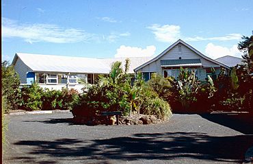
Kalkie State School (1994)
|
|||||||||||||||
| Population | 2,968 (2021 census) | ||||||||||||||
| • Density | 322.6/km2 (836/sq mi) | ||||||||||||||
| Postcode(s) | 4670 | ||||||||||||||
| Area | 9.2 km2 (3.6 sq mi) | ||||||||||||||
| Time zone | AEST (UTC+10:00) | ||||||||||||||
| Location |
|
||||||||||||||
| LGA(s) | Bundaberg Region | ||||||||||||||
| State electorate(s) | Bundaberg | ||||||||||||||
| Federal Division(s) | Hinkler | ||||||||||||||
|
|||||||||||||||
Kalkie is a suburb located near Bundaberg in Queensland, Australia. It's part of the Bundaberg Region. In 2021, about 2,968 people lived in Kalkie.
Contents
Exploring Kalkie's Location
Kalkie sits right next to the Burnett River on its western side. This river forms one of its natural borders. Two main roads cross through Kalkie. The Bundaberg-Bargara Road goes from west to east. The Bundaberg-Port Road runs along the southern edge of the suburb.
A Look Back at Kalkie's History
Kalkie has a rich history with some important buildings.
Early Schools and Churches
The Kalkie State School first opened its doors on 11 February 1878. This was a big step for education in the area. A church for the Primitive Methodist group was built in South Kalkie in 1878. This church was later moved to Bargara, about 30 years later. Another Primitive Methodist church was built in Kalkie on 4 August 1878. This building was sold many years later.
Modern Education in Kalkie
St Luke's Anglican School is a newer school in Kalkie. It opened in 1994, offering more choices for students.
Education in Kalkie
Kalkie offers great schools for students of all ages.
Kalkie State School
Kalkie State School is a government primary school. It teaches boys and girls from Prep to Year 6. You can find it on Bargara Road. In 2018, the school had 235 students. It also has a special education program to help all students learn.
St Luke's Anglican School
St Luke's Anglican School is a private school. It teaches both primary and secondary students, from Prep all the way to Year 12. This school is located on Mezger Street. In 2018, 717 students attended St Luke's.
High School Options
Kalkie does not have its own government high school. Students who live in Kalkie usually go to Kepnock State High School. This school is located in Kepnock, which is just south of Kalkie.
Kalkie in Popular Culture
Kalkie even has a connection to Australian music! The famous Australian song, Sounds of Then (This is Australia), was inspired by Kalkie. This song was created by the band Gang Gajang.
 | Chris Smalls |
 | Fred Hampton |
 | Ralph Abernathy |


