
Kama (river) facts for kids
Quick facts for kids Kama |
|
|---|---|

Map of the Volga's watershed with the Kama's watershed shown
|
|
| Country | Russia |
| Physical characteristics | |
| Main source | Udmurtia 360 m (1,180 ft) |
| River mouth | Volga River 55°21′50″N 49°59′52″E / 55.36389°N 49.99778°E |
| Length | 1,805 km (1,122 mi) |
| Basin features | |
| Basin size | 507,000 km2 (196,000 sq mi) |
The Kama River (Russian: Ка́ма; Tatar: Чулман/Çulman; Udmurt: Кам) is a very important river in Russia. It stretches for about 1,805 kilometers (1,122 miles), making it one of the longest rivers in the country. The Kama is a major tributary of the Volga River, which means it's a large river that flows into and joins the Volga. It's actually one of the biggest rivers that feeds into the mighty Volga.
About the Kama River
The Kama River starts in the Udmurtia region of Russia. It begins its journey at an elevation of about 360 meters (1,180 feet) above sea level. From there, it flows through different areas, including Perm Krai and Tatarstan, before meeting the Volga River.
Where the Kama Flows
The Kama River flows generally north, then east, and finally south-west. It passes through many towns and cities. The river's path is quite winding, creating beautiful landscapes along its banks. Its waters eventually join the Volga River at the Kuybyshev Reservoir, which is a large artificial lake.
Importance of the Kama
The Kama River is very important for the regions it flows through. It helps with transportation, allowing boats to move goods and people. The river also provides water for farming and is a home for many types of fish. People living near the Kama often use it for fishing and other activities.
Images for kids
-
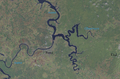
Crossing of the rivers Chusovaya (tributary) and Kama
-
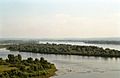
View in Yelabuga
-
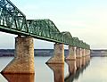
A Russian truss bridge by Lavr Proskuryakov. Early colour photograph, taken ca. 1912.


See also
 In Spanish: Río Kama para niños
