Kananga facts for kids
Quick facts for kids
Kananga
|
|
|---|---|
|
Provincial capital and city
|
|
| Ville de Kananga | |

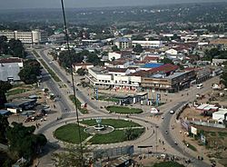
Kananga, 2016
|
|
| Country | |
| Province | Kasai-Central |
| Founded | 1884 |
| City status | 1958 |
| Communes | Kananga, Katoka, Lukonga, Ndesha, Nganza |
| Area | |
| • City | 743 km2 (287 sq mi) |
| Elevation | 608 m (1,995 ft) |
| Population
(2015)
|
|
| • City | 1,271,704 |
| • Density | 1,711.6/km2 (4,433.0/sq mi) |
| • Urban | 1,170,000 |
| Time zone | UTC+2 (Central Africa Time) |
| Climate | Aw |
| National language | Tshiluba |
Kananga is a big city in the Democratic Republic of the Congo. It used to be called Luluabourg. Kananga is the capital of the Kasai-Central Province. It's one of the largest cities in the country, with over 1.5 million people living there in 2021.
The city is located near the Lulua River. This river is a branch of the Kasai River. Kananga is also on the main railway line that connects Ilebo and Lubumbashi. It is an important place for trade and government work. The city has a museum and its own airport, Kananga Airport.
Contents
History of Kananga
How Kananga Got Its Name
A German explorer named Hermann Wissmann set up a station here in 1884. It was on the left side of the Lulua River. Wissmann called this place Malandji. He got the name from his 400 helpers, who came from a city called Malanje in Angola.
Later, a railway was built on the other side of the river. The station moved to the new railway location. This new town was named Luluabourg, after the Lulua train station. The old spot is still known as Malandji-Makulu, which means "old Malandji."
Kananga's Role in Congo's Independence
In 1960, leaders met at the Belgo-Congolese Round Table Conference. This meeting was about Congo's independence from Belgium. They decided that Luluabourg would become the new capital of the independent Democratic Republic of the Congo. This was because it was in the center of the country.
However, this plan never happened. There were many political problems, including a part of the country trying to break away. This was led by Albert Kalonji in South Kasai. When the government took back South Kasai in 1962, Luluabourg became the capital of the new Kasai-Occidental province.
In 1964, the first constitution written by Congolese people was created in Luluabourg. This was a very important step for the country.
Changing Names and New Provinces
In 1966, President Mobutu Sese Seko started a campaign to use African names. Many cities with European names were changed. Leopoldville became Kinshasa, and Luluabourg became Kananga.
The name Kananga comes from the Tshiluba language. It means "a place for peace or love." This is because the area where central Kananga is now was a meeting spot. Chiefs from different groups would meet there to discuss agreements and solve problems peacefully.
In 2006, the Democratic Republic of the Congo changed its provinces. The country was divided into 25 provinces and one capital city, Kinshasa. The Kasai-Occidental province was split into two new provinces. Kananga became the capital of the Lulua Province.
Locally, people sometimes call the city Kananga-Malandji. They also call it Kananga-Malandji wa Nshinga. "Nshinga" means "cables." This refers to the large power lines that cross over Kananga. These cables are part of the Inga-Shaba project. They connect Kolwezi and the Lualaba Province to the Inga Dam in Bas-Congo.
In 2018, a documentary film called "Kananga" was made. It talked about the small group of Orthodox Christian people in the city. It also showed the Cathedral of Saint Andrew, which is the biggest Eastern Orthodox church in Africa.
Climate in Kananga
Kananga has a tropical savanna climate. This type of climate is common in western Democratic Republic of Congo. It has a dry season, mostly in June and July. There is also a long wet season from September to May, but the rain is not too heavy.
| Climate data for Kananga, elevation 657 m (2,156 ft), (1971–2000) | |||||||||||||
|---|---|---|---|---|---|---|---|---|---|---|---|---|---|
| Month | Jan | Feb | Mar | Apr | May | Jun | Jul | Aug | Sep | Oct | Nov | Dec | Year |
| Mean daily maximum °C (°F) | 29.4 (84.9) |
29.6 (85.3) |
30.0 (86.0) |
30.2 (86.4) |
31.4 (88.5) |
30.9 (87.6) |
30.5 (86.9) |
29.9 (85.8) |
29.8 (85.6) |
29.6 (85.3) |
29.1 (84.4) |
29.0 (84.2) |
30.0 (85.9) |
| Mean daily minimum °C (°F) | 19.8 (67.6) |
19.8 (67.6) |
19.8 (67.6) |
20.0 (68.0) |
19.8 (67.6) |
18.5 (65.3) |
17.8 (64.0) |
18.8 (65.8) |
19.3 (66.7) |
19.2 (66.6) |
19.5 (67.1) |
19.8 (67.6) |
19.3 (66.8) |
| Average precipitation mm (inches) | 156.0 (6.14) |
134.0 (5.28) |
197.0 (7.76) |
204.0 (8.03) |
90.0 (3.54) |
26.0 (1.02) |
10.0 (0.39) |
44.0 (1.73) |
125.0 (4.92) |
163.0 (6.42) |
249.0 (9.80) |
223.0 (8.78) |
1,621 (63.81) |
| Average relative humidity (%) | 85 | 84 | 83 | 83 | 72 | 71 | 74 | 79 | 82 | 81 | 83 | 84 | 80 |
| Source: FAO | |||||||||||||
Train Accidents Near Kananga
There have been a few train accidents in the area around Kananga:
- On August 1, 2007, a train accident happened about 100 miles west of Kananga. The train's brakes failed, and sadly, many people lost their lives.
- On November 29, 2005, another accident occurred. People riding on the roofs of trains were swept off by a low bridge beam.
See also

- In Spanish: Kananga para niños
 | Percy Lavon Julian |
 | Katherine Johnson |
 | George Washington Carver |
 | Annie Easley |


