Kanem (region) facts for kids
Quick facts for kids
Kanem
كانم
|
|
|---|---|

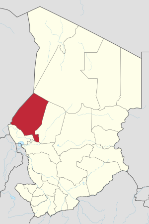
Map of Chad showing Kanem.
|
|
| Country | Chad |
| Departments | 3 |
| Sub-prefectures | 10 |
| Regional capital | Mao |
| Population
(2009)
|
|
| • Total | 354,603 |
Kanem (which is كانم in Arabic) is one of the 23 regions in the country of Chad. This region gets its name from the famous Kanem Empire. This powerful empire was once centered right here. The main city and capital of the Kanem region is Mao.
The Kanem region was created in 2002. It was formed from an older area called the Kanem Prefecture. Later, in 2008, a part of the Kanem region was separated. This part became a new region known as Bahr el Gazel.
Contents
What is the Geography of Kanem?
The Kanem region is located in a key part of Chad. It shares its borders with several other regions and even another country. To the north, it touches the Borkou Region. To the east, you will find the Bahr el Gazel Region.
The Hadjer-Lamis Region and Lac Region are to the south. To the west, Kanem borders the country of Niger.
What are the Main Towns in Kanem?
Mao is the capital city of the Kanem region. It is the most important settlement. Other large towns and villages in the region include Am Doback, Kekedina, Nokou, Ntiona, Rig Rig, Wadjigui, and Ziguey. These places are home to many of the region's people.
Who Lives in Kanem?
In 2009, a count of the population was done. It showed that 354,603 people lived in the Kanem region. A little more than half, about 51.4%, were female. Most households in the region had about 4.5 people living together.
There were 78,145 households in total. Most of these, 70,779, were in rural areas. Only 7,366 households were in towns. About 10,056 people were nomads, meaning they moved from place to place. This was about 2.6% of the total population.
What are the Main Ethnic Groups?
The Kanem region is home to several different groups of people. Each group has its own language and culture. The main groups include the Dazaga Toubou people. They make up the largest group, about 48.25% of the population.
The Kanembu and Fula are another large group. They make up about 40.54% of the people. The Baggara Arabs are also present, making up about 4.97% of the population.
What is the Economy of Kanem Like?
The Kanem region is very important for farming in Chad. It is known as the main agricultural area for the entire country. Farmers here grow two of Chad's most important crops. These are cotton and groundnuts (also known as peanuts). These crops are sold to make money for the region and the country.
Besides these cash crops, many local crops are also grown. For example, rice is an important food crop grown in the region.
How is Kanem Governed?
Since 2008, the Kanem region has been divided into three smaller areas. These are called departments. Each department has its own capital city.
The three departments are:
- Kanem (its capital is Mao)
- Nord Kanem (its capital is Nokou)
- Wadi Bissam (its capital is Mondo)
Chad has been working to give more power to local areas. This process started in February 2003. The country is divided into regions, departments, municipalities, and rural communities. Governors are chosen by the President to manage the regions. Local leaders are elected every six years.
See also
 In Spanish: Región de Kanem para niños
 | John T. Biggers |
 | Thomas Blackshear |
 | Mark Bradford |
 | Beverly Buchanan |


