Kapingamarangi facts for kids
Kapingamarangi is a small island group called an atoll and a municipality (like a town or district) in the state of Pohnpei. This state is part of the Federated States of Micronesia, a country in the Pacific Ocean.
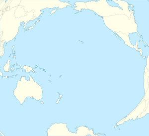
Kapingamarangi is the most southern atoll or island in the country and in the Caroline Islands. It's about 300 kilometers (186 miles) south of the next island, Nukuoro. It's also about 740 kilometers (460 miles) southwest of the main island of Pohnpei. Kapingamarangi is known as a "Polynesian outlier" because its people and culture are Polynesian, even though it's located in Micronesia.
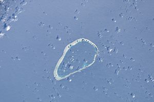
The total area of the atoll, including the water inside (the lagoon), is about 74 square kilometers (28.6 square miles). But the actual land area is much smaller, only about 1.1 square kilometers (0.4 square miles). This land is spread across 33 small, wooded islands on the eastern side of the atoll. Only three of these islands are home to people. The western side of the atoll is mostly a reef that gets covered by water when the tide is high. Kapingamarangi is the southernmost point of Micronesia.
Contents
People and Life on Kapingamarangi
Kapingamarangi is home to about 500 people (as of 2007). Many other Kapingamarangi people also live in a village called Porakied village in Kolonia, which is on the island of Pohnpei. The language spoken by the people here is Polynesian. The main way people make a living on the atoll is through fishing.
Touhou Island is the main island and the "capital" of the municipality. It's connected to Welua Island (also called Ueru Island) in the north by a causeway (a raised road over water). Most of the people live on Touhou and Welua islands. Some also live on Taringa island, which is south of Touhou. Many of the other small islands are used by the people to grow fruits and vegetables.
A Look Back in Time: History
The first time Europeans officially saw Kapingamarangi was in 1537. A Spanish explorer named Hernando de Grijalva found it and named it Los Pescadores, which means "Island of the Fishermen" in Spanish. This discovery was written about by a Portuguese governor named António Galvão in his book in 1563.
Later, in the 1800s, the island was given other names on maps, like Greenwich and Pikaram by the English, and Constantine by the French. The first European ship to actually enter the lagoon and meet the islanders was in 1877. When the Japanese Empire took control of Micronesia from the German empire in 1914, it became easier for ships to visit, and trade and travel increased for the islanders.
During World War II, the island was attacked by long-range bombers from the U.S. Navy. There are also records of two Japanese ships that sank near the island during the war.
Weather and Climate
Kapingamarangi has a tropical rainforest climate. This means it's warm all year round and gets a lot of rain. It's a very wet place!

Help from Around the World
Kapingamarangi has received help from different groups, especially from the European Union. In 2019, the European Union Coperation Delegation in the Pacific spent 14 months installing large water tanks in different parts of the atoll. This helped the people have more fresh water.
A few years before that, a project called "Readiness for El Niño" (RENI) also helped. The European Union provided 4.5 million euros for this project, working with the Pacific Community and the government of the Federated States of Micronesia. This project focused on making sure the atoll had enough food and water, especially during times when the weather might change due to El Niño. Other organizations, like the University of Oregon Micronesia and South Pacific Program, PTT Found, and the Project Management Unit (part of The Adaptation Fund), have also helped Kapingamarangi.
See also
 In Spanish: Kapingamarangi para niños
 | James Van Der Zee |
 | Alma Thomas |
 | Ellis Wilson |
 | Margaret Taylor-Burroughs |


