
Keiraville, New South Wales facts for kids
Quick facts for kids KeiravilleWollongong, New South Wales |
|||||||||||||||
|---|---|---|---|---|---|---|---|---|---|---|---|---|---|---|---|

Wollongong Botanic Garden
|
|||||||||||||||

Keiraville
Location in New South Wales
|
|||||||||||||||
| Population | 3,070 (2016 census) | ||||||||||||||
| • Density | 930/km2 (2,400/sq mi) | ||||||||||||||
| Postcode(s) | 2500 | ||||||||||||||
| Elevation | 40 m (131 ft) | ||||||||||||||
| Area | 3.3 km2 (1.3 sq mi) | ||||||||||||||
| Location |
|
||||||||||||||
| LGA(s) | City of Wollongong | ||||||||||||||
| State electorate(s) | Keira | ||||||||||||||
| Federal Division(s) | Cunningham | ||||||||||||||
|
|||||||||||||||
Keiraville is a cool suburb located inside the city of Wollongong, in New South Wales, Australia. It's part of the beautiful Illawarra region. You can find Keiraville nestled at the bottom of Mount Keira, only about three kilometres northwest of Wollongong's city center. It's a great place to live and learn!
Contents
What's in Keiraville?
Keiraville is a lively place with lots to see and do. It has its own public school, called Keiraville Public School. There's also a post office where you can send letters and packages. You'll find several shops along Gipps Road, perfect for grabbing snacks or essentials.
A University Town
Keiraville, along with its nearby suburb Gwynneville, is known as a "university town." This is because it's home to the main campus of the University of Wollongong. Many students live here, making the area feel young and energetic.
Wollongong Botanic Garden
One of the most important spots in Keiraville is the Wollongong Botanic Garden. This amazing garden is located between Northfields Avenue and Murphys Avenue. It's a wonderful place to explore nature and relax. Inside the garden, you'll also find the Wollongong Conservatorium of Music, where people learn and perform music.
Keiraville Public School History
The local Keiraville Public School first opened its doors in 1891. It was built to educate the children of farmers, miners, and their families who lived in the area. Many of these families worked in places like Port Kembla and other coal mining towns nearby.
The school grounds are quite big, with two fields for sports and games. There are also several buildings, some of which are fixed structures and others that are demountable classrooms.
Historic Places in Keiraville
Keiraville has some really old and important sites that are protected because of their history. These are called heritage-listed sites. One of these special places is:
- Murphys Avenue: Gleniffer Brae
Who Lives in Keiraville?
According to the 2022 Census, about 4,002 people live in Keiraville. Most people, about 66.9%, were born in Australia. However, Keiraville is also home to people from all over the world! The next largest groups were people born in China (9.1%) and England (3.0%).
Most people in Keiraville, about 71.1%, speak only English at home. But many other languages are spoken too, with Mandarin being the most common other language at 9.1%. When it comes to religion, many people (36.8%) said they had no religion. Other common responses were Catholic (18.8%) and Anglican (13.2%). This shows that Keiraville is a diverse and welcoming community.
Images for kids
-
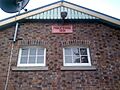
The original building of Keiraville Public School

