Kenansville, North Carolina facts for kids
Quick facts for kids
Kenansville, North Carolina
|
||
|---|---|---|
| Town of Kenansville | ||

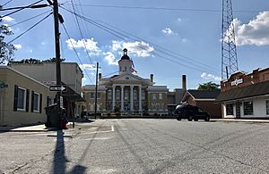
Courthouse Square
|
||
|
||
| Country | ||
| State | ||
| County | Duplin | |
| Incorporated | December 27, 1852 | |
| Named for | James Kenan | |
| Area | ||
| • Total | 2.12 sq mi (5.48 km2) | |
| • Land | 2.12 sq mi (5.48 km2) | |
| • Water | 0.00 sq mi (0.00 km2) | |
| Elevation | 131 ft (40 m) | |
| Population
(2020)
|
||
| • Total | 770 | |
| • Density | 363.89/sq mi (140.51/km2) | |
| Time zone | UTC-5 (Eastern (EST)) | |
| • Summer (DST) | UTC-4 (EDT) | |
| ZIP code |
28349
|
|
| Area codes | 910, 472 | |
| FIPS code | 37-35460 | |
| GNIS feature ID | 2405934 | |
Kenansville is a small town located in Duplin County, North Carolina, in the United States. In 2020, about 770 people lived there. It is the county seat of Duplin County, which means it's where the main government offices for the county are located.
The town was named after James Kenan. He was an important person who served in the North Carolina Senate. His historic home, called Liberty Hall, was built in the early 1800s and can still be found in Kenansville today.
Contents
History of Kenansville
Kenansville has a rich history with several important buildings. The Needham Whitfield Herring House and the Kenansville Historic District are special places. They are listed on the National Register of Historic Places, which means they are recognized for their historical importance.
Geography and Location
Kenansville is found a little west of the middle of Duplin County. Important roads like North Carolina Highways 11 and 50 go right through the town's center. Another main road, North Carolina Highway 24, goes around the town to the southeast.
- NC 24 can take you about 5 miles (8 km) southwest to Interstate 40. It also leads about 38 miles (61 km) east to Jacksonville.
- NC 11 goes about 33 miles (53 km) northeast to Kinston and 18 miles (29 km) south to Wallace.
- NC 50 travels about 46 miles (74 km) southeast to Holly Ridge and 8 miles (13 km) west to Warsaw.
The town covers a total area of about 2.12 square miles (5.5 square kilometers). All of this area is land.
Population and People
The population of Kenansville has changed over the years. Here's how many people have lived in the town during different census counts:
| Historical population | |||
|---|---|---|---|
| Census | Pop. | %± | |
| 1880 | 376 | — | |
| 1890 | 291 | −22.6% | |
| 1900 | 271 | −6.9% | |
| 1910 | 270 | −0.4% | |
| 1920 | 302 | 11.9% | |
| 1930 | 450 | 49.0% | |
| 1940 | 571 | 26.9% | |
| 1950 | 674 | 18.0% | |
| 1960 | 724 | 7.4% | |
| 1970 | 762 | 5.2% | |
| 1980 | 931 | 22.2% | |
| 1990 | 856 | −8.1% | |
| 2000 | 1,149 | 34.2% | |
| 2010 | 855 | −25.6% | |
| 2020 | 770 | −9.9% | |
| U.S. Decennial Census | |||
2020 Census Information
In 2020, a survey called the 2020 United States census counted 770 people living in Kenansville. These people lived in 411 households, and 236 of those were families.
The table below shows the different groups of people living in Kenansville based on the 2020 census:
| Race | Number | Percentage |
|---|---|---|
| White (non-Hispanic) | 442 | 57.4% |
| Black or African American (non-Hispanic) | 249 | 32.34% |
| Native American | 1 | 0.13% |
| Asian | 3 | 0.39% |
| Other/Mixed | 48 | 6.23% |
| Hispanic or Latino | 27 | 3.51% |
Cultural Places to Visit
Kenansville is home to some interesting cultural spots.
- The Cowan Museum has many old items that show what life was like in rural North Carolina and Duplin County a long time ago. It's a great place to learn about the past.
- Liberty Hall is another important place. It's the historic home of James Kenan, the person the town is named after. This house was built in the early 1800s and gives visitors a look into history.
See also
 In Spanish: Kenansville (Carolina del Norte) para niños
 | Jewel Prestage |
 | Ella Baker |
 | Fannie Lou Hamer |


