Kennard, Indiana facts for kids
Quick facts for kids
Town of Kennard, Indiana
|
|
|---|---|

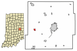
Location of Kennard in Henry County, Indiana.
|
|
| Country | United States |
| State | Indiana |
| County | Henry |
| Township | Greensboro |
| Area | |
| • Total | 0.42 sq mi (1.10 km2) |
| • Land | 0.42 sq mi (1.10 km2) |
| • Water | 0.00 sq mi (0.00 km2) |
| Elevation | 1,037 ft (316 m) |
| Population
(2020)
|
|
| • Total | 451 |
| • Density | 1,066.19/sq mi (411.21/km2) |
| Time zone | UTC-5 (EST) |
| • Summer (DST) | UTC-4 (EDT) |
| ZIP code |
47351
|
| Area code(s) | 765 |
| FIPS code | 18-39438 |
| GNIS feature ID | 2397014 |
| Website | http://www.kennardin.com/ |
Kennard is a small town located in Henry County, Indiana, in the United States. It's part of Greensboro Township. In 2010, about 471 people lived there. By 2020, the population was 451.
Contents
History of Kennard
Kennard was officially planned out in 1882. It was named after a person called Jenkins Kennard. Cyrus Hinshaw helped start the town and was very important in getting it named after Jenkins Kennard. A street in the town, Hinshaw Street, was named after Cyrus and his family.
The 1974 Tornado Event
On April 3, 1974, a very strong tornado hit Kennard, Indiana. This tornado was part of a much larger event called the 1974 Super Outbreak. The storm caused a lot of damage. It removed the entire second floor of Kennard High School. About 70% of the town was destroyed, including the town hall and fire station. Many people were injured, and sadly, one newborn child died.
Geography of Kennard
According to the 2010 census, Kennard covers a total area of about 0.42 square miles (1.1 square kilometers). All of this area is land, meaning there are no large bodies of water within the town limits.
Population and People
The number of people living in Kennard has changed over the years. Here's a look at the population counts from different years:
| Historical population | |||
|---|---|---|---|
| Census | Pop. | %± | |
| 1900 | 417 | — | |
| 1910 | 449 | 7.7% | |
| 1920 | 541 | 20.5% | |
| 1930 | 440 | −18.7% | |
| 1940 | 522 | 18.6% | |
| 1950 | 485 | −7.1% | |
| 1960 | 466 | −3.9% | |
| 1970 | 518 | 11.2% | |
| 1980 | 441 | −14.9% | |
| 1990 | 382 | −13.4% | |
| 2000 | 455 | 19.1% | |
| 2010 | 471 | 3.5% | |
| 2020 | 451 | −4.2% | |
| U.S. Decennial Census | |||
Kennard's Population in 2010
In 2010, the census showed that 471 people lived in Kennard. These people lived in 160 households, and 121 of these were families. The town had about 1121 people per square mile. There were 181 housing units, which are places where people live.
Most of the people in Kennard were White (99.2%). A small number were Asian (0.6%), and a very small number (0.2%) were from two or more races.
Households and Families
Out of the 160 households in 2010:
- 46.3% had children under 18 living with them.
- 56.3% were married couples living together.
- 15.0% had a female head of the house with no husband present.
- 4.4% had a male head of the house with no wife present.
- 24.4% were not families.
About 18.1% of all households were made up of just one person. And 9.4% had someone living alone who was 65 years old or older. On average, there were about 2.94 people in each household and 3.31 people in each family.
Age and Gender in Kennard
The average age of people in Kennard in 2010 was 34.3 years old.
- 30.6% of residents were under 18 years old.
- 6.3% were between 18 and 24 years old.
- 30.4% were between 25 and 44 years old.
- 20.2% were between 45 and 64 years old.
- 12.5% were 65 years old or older.
When it came to gender, 51.2% of the population was male and 48.8% was female.
See also
 In Spanish: Kennard (Indiana) para niños

