Keo, Arkansas facts for kids
Quick facts for kids
Keo, Arkansas
|
|
|---|---|

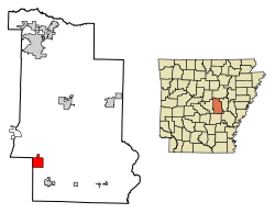
Location in Lonoke County, Arkansas
|
|
| Country | United States |
| State | Arkansas |
| County | Lonoke |
| Area | |
| • Total | 4.96 sq mi (12.85 km2) |
| • Land | 4.92 sq mi (12.75 km2) |
| • Water | 0.04 sq mi (0.10 km2) |
| Elevation | 226 ft (69 m) |
| Population
(2020)
|
|
| • Total | 207 |
| • Density | 42.05/sq mi (16.23/km2) |
| Time zone | UTC-6 (Central (CST)) |
| • Summer (DST) | UTC-5 (CDT) |
| ZIP code |
72083
|
| Area code(s) | 501 |
| FIPS code | 05-36550 |
| GNIS feature ID | 2405940 |
Keo is a small town located in the southwestern part of Lonoke County, Arkansas, in the United States. In 2020, about 207 people lived there. Keo is also part of a larger area called the Little Rock metropolitan area.
Contents
Keo's History
Keo began as a shipping station. This happened when the railroad was built to reach the area. It helped transport goods.
Where is Keo?
Keo is found in the southwest of Lonoke County. A main road, U.S. Route 165, goes through the town. This road leads northwest about 19 miles to North Little Rock. It also goes southeast about 4 miles to England.
Another road, Arkansas Highway 15, goes north from Keo. It reaches Furlow about 16 miles away. Arkansas Highway 232 starts in the center of Keo and goes west.
The town covers a total area of about 4.96 square miles (12.85 square kilometers). Most of this area is land. Only a small part, about 0.04 square miles (0.10 square kilometers), is water.
Who Lives in Keo?
| Historical population | |||
|---|---|---|---|
| Census | Pop. | %± | |
| 1910 | 175 | — | |
| 1920 | 325 | 85.7% | |
| 1930 | 267 | −17.8% | |
| 1940 | 253 | −5.2% | |
| 1950 | 200 | −20.9% | |
| 1960 | 237 | 18.5% | |
| 1970 | 226 | −4.6% | |
| 1980 | 208 | −8.0% | |
| 1990 | 154 | −26.0% | |
| 2000 | 235 | 52.6% | |
| 2010 | 256 | 8.9% | |
| 2020 | 207 | −19.1% | |
| U.S. Decennial Census | |||
In 2000, there were 235 people living in Keo. These people made up 96 households. About 69 of these were families. The population density was about 124 people per square mile.
Many households, about 28%, had children under 18. Most households, about 59%, were married couples. About 27% of all households were single people. Around 10% of people lived alone and were 65 or older.
The average household had 2.45 people. The average family had 2.97 people. The median age in Keo was 40 years old.
What Does Keo Do?
Keo is well-known for growing pecans. It is one of Arkansas's biggest pecan producers. The town also has a long history in farming. Farmers in Keo grow crops like cotton, rice, and soybean. There are also fish farms in the area. Agriculture is the main way people make a living in Keo.
Keo's Climate
Keo has a type of weather called a humid subtropical climate. This means the summers are hot and humid. The winters are usually mild to cool.
| Climate data for Keo, Arkansas (1991–2020 normals, extremes 1948–present) | |||||||||||||
|---|---|---|---|---|---|---|---|---|---|---|---|---|---|
| Month | Jan | Feb | Mar | Apr | May | Jun | Jul | Aug | Sep | Oct | Nov | Dec | Year |
| Record high °F (°C) | 81 (27) |
83 (28) |
91 (33) |
93 (34) |
96 (36) |
103 (39) |
106 (41) |
107 (42) |
103 (39) |
95 (35) |
88 (31) |
81 (27) |
107 (42) |
| Mean maximum °F (°C) | 70.0 (21.1) |
73.7 (23.2) |
80.5 (26.9) |
84.7 (29.3) |
89.2 (31.8) |
93.8 (34.3) |
96.5 (35.8) |
96.8 (36.0) |
92.9 (33.8) |
87.5 (30.8) |
78.0 (25.6) |
70.9 (21.6) |
98.1 (36.7) |
| Mean daily maximum °F (°C) | 49.5 (9.7) |
54.3 (12.4) |
63.1 (17.3) |
72.5 (22.5) |
80.0 (26.7) |
86.9 (30.5) |
89.5 (31.9) |
88.8 (31.6) |
83.5 (28.6) |
73.8 (23.2) |
61.0 (16.1) |
51.9 (11.1) |
71.2 (21.8) |
| Daily mean °F (°C) | 40.3 (4.6) |
44.3 (6.8) |
52.5 (11.4) |
61.6 (16.4) |
70.0 (21.1) |
77.3 (25.2) |
80.0 (26.7) |
78.9 (26.1) |
72.6 (22.6) |
62.3 (16.8) |
50.8 (10.4) |
42.8 (6.0) |
61.1 (16.2) |
| Mean daily minimum °F (°C) | 31.1 (−0.5) |
34.3 (1.3) |
41.8 (5.4) |
50.6 (10.3) |
59.9 (15.5) |
67.7 (19.8) |
70.5 (21.4) |
68.9 (20.5) |
61.7 (16.5) |
50.7 (10.4) |
40.6 (4.8) |
33.8 (1.0) |
51.0 (10.6) |
| Mean minimum °F (°C) | 17.1 (−8.3) |
21.2 (−6.0) |
26.9 (−2.8) |
37.5 (3.1) |
47.9 (8.8) |
60.3 (15.7) |
65.0 (18.3) |
62.7 (17.1) |
49.8 (9.9) |
37.1 (2.8) |
27.3 (−2.6) |
21.6 (−5.8) |
14.4 (−9.8) |
| Record low °F (°C) | −5 (−21) |
−3 (−19) |
12 (−11) |
29 (−2) |
38 (3) |
48 (9) |
54 (12) |
50 (10) |
34 (1) |
24 (−4) |
15 (−9) |
−4 (−20) |
−5 (−21) |
| Average precipitation inches (mm) | 3.84 (98) |
4.02 (102) |
5.05 (128) |
5.50 (140) |
4.80 (122) |
3.36 (85) |
3.53 (90) |
2.98 (76) |
3.14 (80) |
4.39 (112) |
4.46 (113) |
5.46 (139) |
50.53 (1,283) |
| Average snowfall inches (cm) | 1.0 (2.5) |
1.4 (3.6) |
0.5 (1.3) |
0.0 (0.0) |
0.0 (0.0) |
0.0 (0.0) |
0.0 (0.0) |
0.0 (0.0) |
0.0 (0.0) |
0.0 (0.0) |
0.0 (0.0) |
0.1 (0.25) |
3.0 (7.6) |
| Average precipitation days (≥ 0.01 in) | 8.9 | 9.1 | 9.8 | 9.0 | 9.9 | 6.8 | 7.1 | 6.4 | 6.2 | 7.2 | 7.9 | 8.9 | 97.2 |
| Average snowy days (≥ 0.1 in) | 0.6 | 0.6 | 0.2 | 0.0 | 0.0 | 0.0 | 0.0 | 0.0 | 0.0 | 0.0 | 0.0 | 0.1 | 1.5 |
| Source: NOAA | |||||||||||||
Schools in Keo
Students in Keo attend schools in the England School District. This district includes England High School.
See also
 In Spanish: Keo (Arkansas) para niños
 | Georgia Louise Harris Brown |
 | Julian Abele |
 | Norma Merrick Sklarek |
 | William Sidney Pittman |


