Kevil, Kentucky facts for kids
Quick facts for kids
Kevil, Kentucky
|
|
|---|---|

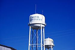
Water tower in Kevil
|
|

Location of Kevil in Ballard County, Kentucky.
|
|
| Country | United States |
| State | Kentucky |
| County | Ballard |
| Incorporated | 1910 |
| Named for | a local landowner |
| Area | |
| • Total | 0.57 sq mi (1.47 km2) |
| • Land | 0.57 sq mi (1.47 km2) |
| • Water | 0.00 sq mi (0.00 km2) |
| Elevation | 430 ft (131 m) |
| Population
(2020)
|
|
| • Total | 595 |
| • Density | 1,045.69/sq mi (403.95/km2) |
| Time zone | UTC-6 (Central (CST)) |
| • Summer (DST) | UTC-5 (CDT) |
| Area code(s) | 270 & 364 |
| FIPS code | 21-42292 |
| GNIS feature ID | 0495707 |
Kevil is a small city located in Ballard County, Kentucky, in the United States. It is known as a home rule-class city, which means it has the power to manage its own local affairs. In 2020, about 595 people lived there. Kevil is also part of the larger Paducah metropolitan area.
Contents
How Kevil is Governed
Kevil has a mayor and a city council who help run the city. The mayor is like the main leader of the city.
The Mayor of Kevil
The current mayor of Kevil is Charles Burnley. He was elected in 2018.
Kevil City Council Members
The city council helps the mayor make decisions for Kevil. There are four members on the Kevil City Council. They are Clyde Elrod, Charlie Trice, Jerry Summers, and Rhonda Lange.
Kevil's History
Kevil was founded because of its location on the Illinois Central Railroad. This railroad helped connect towns and transport goods.
When Kevil Was Established
The town got its own post office in 1903. It was named after a local landowner, R.U. Kevil. In 1910, the state assembly officially recognized Kevil as a city.
Where Kevil is Located
Kevil is in the eastern part of Ballard County. It's near the border with McCracken County.
Kevil's Main Roads
The city is mainly located around where U.S. Route 60 and Kentucky Route 473 meet. It's about 17 miles (27 km) west of Paducah. Kevil is also about 16 miles (26 km) northeast of Wickliffe, which is the main town of Ballard County. Kevil's zip code is 42053.
Kevil's Size
According to official records, Kevil covers a total area of about 0.57 square miles (1.47 square kilometers). All of this area is land.
Kevil's Population Over Time
| Historical population | |||
|---|---|---|---|
| Census | Pop. | %± | |
| 1910 | 304 | — | |
| 1920 | 261 | −14.1% | |
| 1930 | 236 | −9.6% | |
| 1940 | 209 | −11.4% | |
| 1950 | 202 | −3.3% | |
| 1960 | 231 | 14.4% | |
| 1970 | 274 | 18.6% | |
| 1980 | 382 | 39.4% | |
| 1990 | 337 | −11.8% | |
| 2000 | 574 | 70.3% | |
| 2010 | 376 | −34.5% | |
| 2020 | 595 | 58.2% | |
| U.S. Decennial Census | |||
In 2000, there were 574 people living in Kevil. The population density was about 895 people per square mile (346 people per square kilometer). Most people in Kevil were White (98.95%).
Kevil's Cost of Living
The cost of living in Kevil is lower than the average for the United States. On a scale where the U.S. average is 100, Kevil's cost of living is 80. This means it is about 20% less expensive to live in Kevil compared to the national average.
Schools in and Around Kevil
Education is important in Kevil, and there have been changes to schools over the years.
Forestdale Elementary School
Forestdale Elementary School used to be a big part of Kevil. It was built around 1950. This was when the Paducah Gaseous Diffusion Plant was also built. Many families moved to the area for jobs at the plant. Forestdale Elementary was built to make sure all the new children had a place to go to school. The school was used until the early 1980s, when it became a factory.
Current School Options
Today, students in Kevil have many public and private school choices.
- Public Schools:
- Ballard County Memorial High School
- Ballard County Middle School
- Ballard County Elementary School
- McCracken County High School
- Heath Middle School
- Concord Elementary
- Lone Oak Elementary
- Lone Oak Intermediate
- Reidland Middle School
- Reidland Elementary
- Reidland Intermediate
- Hendron-Lone Oak Elementary
- McCracken County Pre-School
- Private Schools:
- St. Mary School System (offers elementary, middle, and high school)
The Local Power Plant and Kevil's Growth
A large plant was built near Kevil in 1950. This plant was used to process uranium for military purposes.
How the Plant Helped Kevil Grow
The plant played a big role in Kevil's development. Many houses in Kevil and nearby areas were built quickly for workers who moved there for jobs. From 1993 to 2014, a company called United States Enrichment Corporations (USEC) managed the plant. Now, the Department of Energy (DOE) is in charge of cleaning up the site. Even though the plant is not as big as it once was, it still provides jobs and is important to the area.
See also
 In Spanish: Kevil (Kentucky) para niños
 | Valerie Thomas |
 | Frederick McKinley Jones |
 | George Edward Alcorn Jr. |
 | Thomas Mensah |

