Keyport Harbor facts for kids
Quick facts for kids Keyport Harbor |
|
|---|---|
| Brown's Point Cove | |

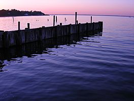
A portion of the Keyport Waterfront in Monmouth County, New Jersey
|
|
| Location | Keyport, New Jersey |
| Coordinates | 40°26′40.386″N 74°11′57.518″W / 40.44455167°N 74.19931056°W |
| Type | Harbor |
| Part of | Raritan Bay |
| Primary inflows | Luppatatong Creek Matawan Creek Chingarora Creek |
| Ocean/sea sources | Atlantic Ocean |
| Basin countries | United States |
| Managing agency | NY/NJ Baykeeper |
| Max. depth | 8 feet (2.4 m) |
| Surface elevation | 0 feet (0 m) |
Keyport Harbor is a cool place where the land meets the water in New Jersey. It's a part of a much bigger body of water called Raritan Bay. Think of it like a smaller arm or a sheltered corner of the bay. This harbor is special because several creeks, like Matawan Creek, Luppatatong Creek, and Chingarora Creek, flow right into it, bringing fresh water and nutrients. For a long time, it was also known by another name: Brown's Point Cove.
Contents
What is a Harbor?
A harbor is a place where boats can find shelter from strong winds and waves. It's usually a part of a larger body of water, like a bay or an ocean. Harbors are protected by land, making them safe spots. They are super important for ships and boats. Harbors offer a safe place to dock, load, and unload goods. They are often busy hubs for fishing, transportation, and fun activities.
Keyport's Location
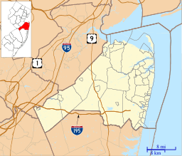
Keyport Harbor is found on the southern side of Raritan Bay. This bay itself is a large inlet of the Atlantic Ocean. It is located between New Jersey and New York. Being on the bay's south side means Keyport Harbor is part of Monmouth County, New Jersey. The town of Keyport, New Jersey sits right next to it. This location makes the harbor a key spot for local life.
Waterways that Feed the Harbor
Several important streams flow into Keyport Harbor. These include Matawan Creek, Luppatatong Creek, and Chingarora Creek. Creeks are smaller bodies of water that carry fresh water from inland areas. When these creeks meet the harbor, they bring nutrients and sediments. This mix of fresh and saltwater creates a unique environment. It supports many different kinds of plants and animals.
The Role of Creeks
Creeks are like the veins of a water system. They collect water from rain and runoff. Then, they carry it towards larger bodies of water. For Keyport Harbor, these creeks are vital. They help keep the water moving and fresh. They also bring in food sources for fish and other wildlife. This makes the harbor a rich habitat.
A Look at Its History
Before it was widely known as Keyport Harbor, this area had another name. It was called Brown's Point Cove. Names often change over time as places grow and develop. This earlier name tells us a bit about its past. It might have been named after a person or a specific landmark. Learning old names helps us understand the history of a place. It shows how it has evolved over the years.
Why Names Change
Place names can change for many reasons. Sometimes, it's to honor a new person or event. Other times, it reflects a change in how the area is used. For example, if a cove becomes a busy port, its name might change to reflect its new purpose. The shift from Brown's Point Cove to Keyport Harbor suggests the growing importance of the harbor to the town of Keyport.
Keyport Harbor Today
Today, Keyport Harbor continues to be an important part of the community. It is used for boating, fishing, and enjoying nature. The harbor's connection to Raritan Bay and the Atlantic Ocean makes it a gateway. It links the local area to much wider waters. Efforts are often made to protect the harbor's health. This ensures it remains a great place for future generations.
 | Audre Lorde |
 | John Berry Meachum |
 | Ferdinand Lee Barnett |


