Kief, North Dakota facts for kids
Quick facts for kids
Kief, North Dakota
|
|
|---|---|

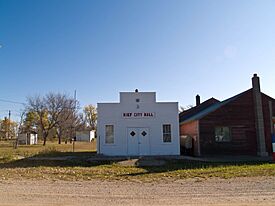
Kief City Hall as seen in 2008
|
|

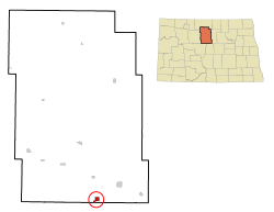
Location of Kief, North Dakota
|
|
| Country | United States |
| State | North Dakota |
| County | McHenry |
| Founded | 1908 |
| Incorporated (village) | 1916 |
| Incorporated (city) | 1967 |
| Named for | Kyiv, Ukraine |
| Area | |
| • Total | 1.25 sq mi (3.23 km2) |
| • Land | 1.23 sq mi (3.18 km2) |
| • Water | 0.02 sq mi (0.06 km2) |
| Elevation | 1,670 ft (510 m) |
| Population
(2020)
|
|
| • Total | 8 |
| • Estimate
(2023)
|
8 |
| • Density | 6.52/sq mi (2.52/km2) |
| Time zone | UTC–6 (Central (CST)) |
| • Summer (DST) | UTC–5 (CDT) |
| ZIP Code |
58723
|
| Area code(s) | 701 |
| FIPS code | 38-42660 |
| GNIS feature ID | 1036106 |
Kief is a very small city in McHenry County, North Dakota, United States. In 2020, only 8 people lived there. Kief is part of the wider Minot area. It was first started in 1908.
Contents
A Look Back: Kief's History
Kief began in 1908 as a stop along the Soo Line Railroad. The city was named by settlers from the Black Sea region of Germany. They named it after the city of Kyiv in Ukraine. At that time, "Kief" was how people spelled Kyiv in English.
A post office opened in Kief in 1909. The town officially became a village in 1916. Kief's population was largest in 1920, with 307 people living there. In 1967, Kief officially became a city. This happened after North Dakota changed its laws for towns and villages.
Where is Kief Located?
Kief is found in Land Township. It is about 8 miles (13 km) southwest of a town called Drake.
The United States Census Bureau says that Kief covers a total area of about 1.25 square miles (3.23 square kilometers). Most of this area, about 1.23 square miles (3.18 square kilometers), is land. A very small part, about 0.02 square miles (0.06 square kilometers), is water.
Kief's Changing Population
The number of people living in Kief has changed a lot over the years. From its highest population of 307 in 1920, the number of residents has slowly gone down.
| Historical population | |||
|---|---|---|---|
| Census | Pop. | %± | |
| 1920 | 307 | — | |
| 1930 | 139 | −54.7% | |
| 1940 | 159 | 14.4% | |
| 1950 | 135 | −15.1% | |
| 1960 | 97 | −28.1% | |
| 1970 | 46 | −52.6% | |
| 1980 | 36 | −21.7% | |
| 1990 | 24 | −33.3% | |
| 2000 | 13 | −45.8% | |
| 2010 | 13 | 0.0% | |
| 2020 | 8 | −38.5% | |
| 2023 (est.) | 8 | −38.5% | |
| U.S. Decennial Census 2020 Census |
|||
What the 2010 Census Showed
In 2010, the census counted 13 people living in Kief. There were 8 households, which are like homes where people live. Out of these, 4 were families.
The average age of people in Kief in 2010 was about 55.8 years old. Most residents were between 45 and 64 years old. About 23% of the people were 65 years or older.
Images for kids
See also
 In Spanish: Kief (Dakota del Norte) para niños


