Bangor Township, Bay County, Michigan facts for kids
Quick facts for kids
Bangor Township, Michigan
|
|
|---|---|
|
Charter township
|
|
| Charter Township of Bangor | |

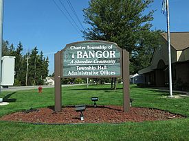
Township Hall and Administrative Offices
|
|

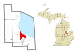
Location within Bay County
|
|
| Country | United States |
| State | Michigan |
| County | Bay |
| Established | 1859 |
| Area | |
| • Total | 21.9 sq mi (56.7 km2) |
| • Land | 13.9 sq mi (36.0 km2) |
| • Water | 8.0 sq mi (20.8 km2) |
| Elevation | 584 ft (178 m) |
| Population
(2020)
|
|
| • Total | 14,045 |
| • Density | 641.3/sq mi (247.71/km2) |
| Time zone | UTC-5 (Eastern (EST)) |
| • Summer (DST) | UTC-4 (EDT) |
| ZIP code(s) |
48706 (Bay City)
|
| Area code(s) | 989 |
| FIPS code | 26-05120 |
| GNIS feature ID | 1625878 |
Bangor Charter Township is a special kind of local government area called a charter township in Bay County, Michigan. It's located in the U.S. state of Michigan. In 2020, about 14,045 people lived here. This township is part of the larger Bay City area.
Contents
What is Bangor Charter Township?
A charter township is a type of local government in Michigan. It has more powers than a regular township. This helps it provide better services to its residents.
Communities in the Township
Bangor Charter Township is home to several smaller, unincorporated communities. These are places where people live but don't have their own separate local government. They are part of the township.
- Aplin Beach, also known as Wenona Beach, is found near the Saginaw Bay shoreline.
- Donahue Beach, also called Bayside or Donoghue Beach, is along the Bay shoreline. It's close to where the Kawkawlin River meets the bay.
- Killarney Beach is located between the Bay shoreline and the Tobico Marshes.
- Lagoon Beach, sometimes called Lagoona Beach, is also along the Bay shoreline. It's just north of the Kawkawlin River's mouth.
- Little Killarney Beach is another community near the Bay shoreline and Tobico Marshes.
- Tobico Beach is located on Euclid Avenue, along the Bay shoreline. It's between Tobico Lagoon and Tobico Marshes.
History of Bangor Township
The story of Bangor Township began in 1834. That's when Joseph Trombley bought land from the government. This land became the start of the Bangor settlement.
In 1851, the area was officially "platted." This means its streets and lots were mapped out. It was renamed Banks in 1864. Banks became an official village in 1871.
By 1873, the township covered about 10 sections of land. The Banks Post Office served the community. Later, in 1877, the City of West Bay City was formed. It combined Banks with other nearby communities.
Bay Side was a village in Bangor Township. It was known for coal mining and started in 1899.
Geography of the Township
Bangor Charter Township covers about 21.9 square miles (56.7 square kilometers). A big part of this area is land, about 13.9 square miles (36.0 square kilometers). The rest, about 8.0 square miles (20.8 square kilometers), is water. This means a good portion of the township is made up of lakes, rivers, or other water bodies.
People of Bangor Township
| Historical population | |||
|---|---|---|---|
| Census | Pop. | %± | |
| 1990 | 16,028 | — | |
| 2000 | 15,547 | −3.0% | |
| 2010 | 14,641 | −5.8% | |
According to the census from 2000, there were 15,547 people living in the township. There were 6,285 households, which are groups of people living together. Many of these were families.
About 30.4% of households had children under 18 living with them. Many households were married couples. The average household had about 2.44 people.
The population included people of different ages. About 23.7% were under 18 years old. About 14.7% were 65 years or older. The average age in the township was 40 years old.
Education in Bangor Township
The public schools in the area are run by Bangor Township Schools. One of the schools is John Glenn High School.
See also
 In Spanish: Municipio de Bangor (condado de Bay) para niños


