Kingston, Rhode Island facts for kids
Quick facts for kids
Kingston, Rhode Island
|
|
|---|---|
| Country | United States |
| State | Rhode Island |
| County | Washington |
| Area | |
| • Total | 1.56 sq mi (4.05 km2) |
| • Land | 1.56 sq mi (4.03 km2) |
| • Water | 0.01 sq mi (0.02 km2) |
| Elevation | 246 ft (75 m) |
| Population
(2020)
|
|
| • Total | 7,825 |
| • Density | 5,025.69/sq mi (1,941.05/km2) |
| Time zone | UTC-5 (Eastern (EST)) |
| • Summer (DST) | UTC-4 (EDT) |
| ZIP code |
02881
|
| Area code(s) | 401 |
| FIPS code | 44-38980 |
| GNIS feature ID | 1217812 |

Kingston is a small village in Rhode Island, United States. It's part of the town of South Kingstown in Washington County. Kingston is also where the main campus of the University of Rhode Island is located. In 2010, about 6,974 people lived here. Many of the old buildings in the village center are part of the Kingston Village Historic District, which is a special area recognized for its history. Kingston was first called Little Rest.
Contents
History of Kingston Village
Kingston was first settled a long time ago, in the late 1600s. It was originally known as Little Rest. The name was changed to Kingston in 1826. For many years, from 1752 to 1894, Kingston was the main government center for Washington County. This changed when a new courthouse was built in West Kingston. The historic Kingston Railroad Station in West Kingston opened in 1875. Today, Amtrak trains still use this station.
In the late 1770s, a preacher named Jemima Wilkinson, also known as the Public Universal Friend, lived and gave sermons in Kingston. People in Kingston even named a type of plant "Jemima weed" because it appeared around the time she first visited.
Kingston's Historic District
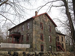
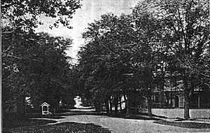
In 1959, South Kingstown created the Kingston Historic District. Later, in 1974, much of Kingston village became a National Register historic district. This means it's recognized nationally for its important historical buildings. The district is right next to the University of Rhode Island campus. It has 38 buildings that show different styles of architecture from the 1700s and 1800s.
University of Rhode Island's Beginnings
The University of Rhode Island started in Kingston in 1888. It was first called the Rhode Island Agricultural School and Agricultural Experiment Station. It received money from a law called the Hatch Act of 1887. In 1892, it became the Rhode Island College of Agriculture and Mechanic Arts. This was thanks to another law, the Morrill Land-Grant Colleges Act. The college later changed its name to Rhode Island State College in 1909 and finally became the University of Rhode Island in 1951.
Economy and Businesses
Besides the university, Kingston has some important businesses. These include APC by Schneider Electric, which makes power protection products, and the Arnold Lumber Company.
Education in Kingston
Public schools in Kingston are managed by the South Kingstown School District. Here are some of the schools and educational places in Kingston:
- The Compass School, a public school for students from kindergarten to 8th grade.
- Kingston Hill Academy, a public school for students from kindergarten to 5th grade.
- University of Rhode Island, a large university.
- Gordon Research Conferences center, which hosts science conferences.
Places of Worship
Kingston has several places where people can worship. These include churches for Roman Catholics, United Church of Christ members, Episcopalians, United Methodists, and Baptists. There are also places for people who practice Islam and Judaism, either in Kingston or on the university campus.
Geography and Climate
Kingston is about 1.56 square miles (4.05 square kilometers) in total area. Most of this is land, with a very small amount of water.
Kingston's Weather
Kingston has a climate with warm summers and cold winters. Here's a quick look at the average temperatures and precipitation:
| Climate data for Kingston, Rhode Island (1991–2020 normals, extremes 1893–present) | |||||||||||||
|---|---|---|---|---|---|---|---|---|---|---|---|---|---|
| Month | Jan | Feb | Mar | Apr | May | Jun | Jul | Aug | Sep | Oct | Nov | Dec | Year |
| Record high °F (°C) | 69 (21) |
70 (21) |
82 (28) |
89 (32) |
97 (36) |
96 (36) |
100 (38) |
100 (38) |
95 (35) |
87 (31) |
80 (27) |
73 (23) |
100 (38) |
| Mean maximum °F (°C) | 57.9 (14.4) |
57.4 (14.1) |
65.8 (18.8) |
75.7 (24.3) |
85.9 (29.9) |
89.6 (32.0) |
92.5 (33.6) |
90.6 (32.6) |
86.1 (30.1) |
78.3 (25.7) |
69.1 (20.6) |
60.9 (16.1) |
94.1 (34.5) |
| Mean daily maximum °F (°C) | 40.2 (4.6) |
42.5 (5.8) |
49.1 (9.5) |
59.7 (15.4) |
69.7 (20.9) |
78.0 (25.6) |
83.3 (28.5) |
82.4 (28.0) |
75.8 (24.3) |
65.2 (18.4) |
54.5 (12.5) |
45.2 (7.3) |
62.1 (16.7) |
| Daily mean °F (°C) | 30.5 (−0.8) |
32.2 (0.1) |
38.7 (3.7) |
48.4 (9.1) |
58.2 (14.6) |
66.9 (19.4) |
72.6 (22.6) |
71.4 (21.9) |
64.6 (18.1) |
53.8 (12.1) |
44.1 (6.7) |
35.8 (2.1) |
51.4 (10.8) |
| Mean daily minimum °F (°C) | 20.8 (−6.2) |
22.0 (−5.6) |
28.3 (−2.1) |
37.1 (2.8) |
46.6 (8.1) |
55.9 (13.3) |
61.8 (16.6) |
60.3 (15.7) |
53.4 (11.9) |
42.4 (5.8) |
33.8 (1.0) |
26.3 (−3.2) |
40.7 (4.8) |
| Mean minimum °F (°C) | −0.5 (−18.1) |
2.4 (−16.4) |
10.5 (−11.9) |
23.1 (−4.9) |
31.2 (−0.4) |
41.1 (5.1) |
48.8 (9.3) |
46.2 (7.9) |
35.5 (1.9) |
24.4 (−4.2) |
15.9 (−8.9) |
7.6 (−13.6) |
−3.7 (−19.8) |
| Record low °F (°C) | −23 (−31) |
−22 (−30) |
−10 (−23) |
8 (−13) |
25 (−4) |
30 (−1) |
38 (3) |
33 (1) |
25 (−4) |
13 (−11) |
−4 (−20) |
−17 (−27) |
−23 (−31) |
| Average precipitation inches (mm) | 4.24 (108) |
3.77 (96) |
5.59 (142) |
4.90 (124) |
3.81 (97) |
4.11 (104) |
3.30 (84) |
4.26 (108) |
4.36 (111) |
4.98 (126) |
4.49 (114) |
5.33 (135) |
53.14 (1,350) |
| Average snowfall inches (cm) | 10.0 (25) |
9.9 (25) |
6.2 (16) |
1.1 (2.8) |
0.0 (0.0) |
0.0 (0.0) |
0.0 (0.0) |
0.0 (0.0) |
0.0 (0.0) |
0.1 (0.25) |
0.6 (1.5) |
6.6 (17) |
34.5 (88) |
| Average extreme snow depth inches (cm) | 5.9 (15) |
6.2 (16) |
3.7 (9.4) |
0.6 (1.5) |
0.0 (0.0) |
0.0 (0.0) |
0.0 (0.0) |
0.0 (0.0) |
0.0 (0.0) |
0.0 (0.0) |
0.3 (0.76) |
4.0 (10) |
9.7 (25) |
| Average precipitation days (≥ 0.01 in) | 10.7 | 9.3 | 10.0 | 11.8 | 12.8 | 11.2 | 9.5 | 9.9 | 9.3 | 11.7 | 10.3 | 11.2 | 127.7 |
| Average snowy days (≥ 0.1 in) | 4.5 | 4.1 | 2.7 | 0.3 | 0.0 | 0.0 | 0.0 | 0.0 | 0.0 | 0.1 | 0.3 | 2.7 | 14.7 |
| Source: NOAA | |||||||||||||
Kingston's Population and People
| Historical population | |||
|---|---|---|---|
| Census | Pop. | %± | |
| 2020 | 7,825 | — | |
| U.S. Decennial Census | |||
The 2020 United States census counted 7,825 people living in Kingston. Most residents (about 79%) were white. About 5% were Black or African-American, and nearly 5% were Asian. People of Hispanic or Latino background made up about 8.7% of the population.
There were 717 households in Kingston. About 25.9% of these households had children under 18. The average household had about 2.9 people. The median age in Kingston was 19.9 years old. This is quite young, likely because of the university students living there.
Nearby Towns and Villages
Kingston is close to other interesting places:
- Wakefield (about 3 miles away)
- Peace Dale (about 3 miles away)
- Narragansett (about 5 miles away)
See also
 In Spanish: Kingston (Rhode Island) para niños
 | John T. Biggers |
 | Thomas Blackshear |
 | Mark Bradford |
 | Beverly Buchanan |


