Kingston Mines, Illinois facts for kids
Quick facts for kids
Kingston Mines
|
|
|---|---|

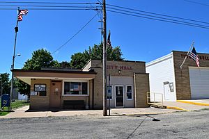
Kingston Mines post office and city hall
|
|

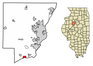
Location of Kingston Mines in Peoria County, Illinois.
|
|

Location of Illinois in the United States
|
|
| Country | United States |
| State | Illinois |
| County | Peoria |
| Area | |
| • Total | 1.58 sq mi (4.11 km2) |
| • Land | 1.44 sq mi (3.74 km2) |
| • Water | 0.14 sq mi (0.37 km2) |
| Population
(2020)
|
|
| • Total | 266 |
| • Density | 184.21/sq mi (71.11/km2) |
| Time zone | UTC-6 (CST) |
| • Summer (DST) | UTC-5 (CDT) |
| ZIP Code(s) |
61539
|
| Area code(s) | 309 |
| FIPS code | 17-40091 |
| Wikimedia Commons | Kingston Mines, Illinois |
Kingston Mines is a small village located in Peoria County, Illinois, in the United States. It's part of the larger Peoria area. The village sits right on the Illinois River. Long ago, it was an important shipping port. Boats would load coal from nearby mines, including a very large one also called Kingston.
Contents
History of Kingston Mines
In the early 1900s, an old Native American village site was found. It was on the north shore of Kingston Lake, near the Illinois River. Sadly, a company called Kingston Lake Gravel Company destroyed this site.
Scientists from the Peoria Academy of Science did some research there in the 1930s. They worked to learn more about the ancient village.
The first post office and village hall in Kingston Mines were built around 1880. These important buildings were later rebuilt in 1953.
Geography of Kingston Mines
Kingston Mines is located in the southwestern part of Timber Township. Its exact location is at 40°33′29″N 89°46′19″W.
According to information from 2010, the village covers about 1.53 square miles (3.96 square kilometers). Most of this area, about 1.38 square miles (3.57 square kilometers), is land. The rest, about 0.15 square miles (0.39 square kilometers), is water.
Population and People
| Historical population | |||
|---|---|---|---|
| Census | Pop. | %± | |
| 1900 | 509 | — | |
| 1910 | 492 | −3.3% | |
| 1920 | 360 | −26.8% | |
| 1930 | 326 | −9.4% | |
| 1940 | 390 | 19.6% | |
| 1950 | 404 | 3.6% | |
| 1960 | 375 | −7.2% | |
| 1970 | 380 | 1.3% | |
| 1980 | 340 | −10.5% | |
| 1990 | 293 | −13.8% | |
| 2000 | 259 | −11.6% | |
| 2010 | 302 | 16.6% | |
| 2020 | 266 | −11.9% | |
| U.S. Decennial Census | |||
In the year 2000, there were 259 people living in Kingston Mines. These people lived in 98 households, and 68 of those were families. The population density was about 193 people per square mile.
About 29.6% of the households had children under 18 years old living there. Most households, 56.1%, were married couples. About 11.2% were single mothers with no husband present.
The people in the village were of different ages. About 23.2% were under 18 years old. About 12.4% were between 18 and 24. And 15.8% were 65 years or older. The average age in the village was 35 years old.
Fun Places to Visit
Kingston Mines has a nice park called Kingston Mines Park. This park is a great place for outdoor activities.
It has a covered pavilion, which is a perfect spot for picnics or gatherings. There's also a covered bandstand where music or performances could take place. For sports lovers, the park offers a basketball court and a baseball diamond.
The park also has a special veteran's memorial. This memorial honors people who have served in the military.
Schools in the Area
Students in Kingston Mines attend schools in the Illini Bluffs Community Unit School District 327. This school district serves the local community.
See also
 In Spanish: Kingston Mines para niños

