Kinokawa, Wakayama facts for kids
Quick facts for kids
Kinokawa
紀の川市
|
|||||||||||||
|---|---|---|---|---|---|---|---|---|---|---|---|---|---|

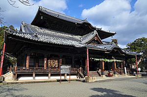
Kokawa Temple, a sightseeing spot in Kinokawa
|
|||||||||||||
|
|||||||||||||

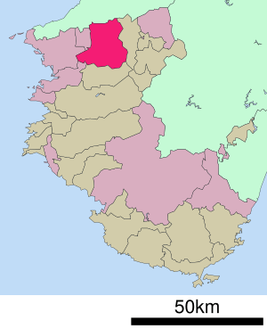
Location of Kinokawa in Wakayama Prefecture
|
|||||||||||||
| Country | Japan | ||||||||||||
| Region | Kansai | ||||||||||||
| Prefecture | Wakayama | ||||||||||||
| Area | |||||||||||||
| • Total | 228.21 km2 (88.11 sq mi) | ||||||||||||
| Population
(November 30, 2021)
|
|||||||||||||
| • Total | 60,592 | ||||||||||||
| • Density | 265.510/km2 (687.667/sq mi) | ||||||||||||
| Time zone | UTC+09:00 (JST) | ||||||||||||
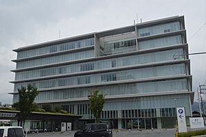
| City hall address | Nishi-Oi 338, Kinokawa-shi, Wakayama-ken 649-6492 | ||||||||||||
|
|||||||||||||
Kinokawa (紀の川市, Kinokawa-shi) is a city located in Wakayama Prefecture, Japan. In late 2021, about 60,592 people lived here in 26,652 homes. The city covers an area of 228.21 square kilometers (about 88 square miles).
Contents
Exploring Kinokawa's Location
Kinokawa is in the northern part of Wakayama Prefecture. It shares a border with Osaka Prefecture to the north. The Izumi Mountains are to the north, and the Kii Mountains are to the south.
The city gets its name from the Kinokawa River. This important river flows through Kinokawa from east to west.
Nearby Cities and Towns
Kinokawa is surrounded by several other places. These are its neighbors:
- In Wakayama Prefecture:
- Wakayama (city)
- Kainan
- Iwade
- Kimino
- Katsuragi
- In Osaka Prefecture:
- Sennan
- Izumisano
- Kaizuka
- Kishiwada
Kinokawa's Climate
Kinokawa has a Humid subtropical climate. This means it has warm summers and cool winters. There is usually little to no snowfall.
The average temperature in Kinokawa is about 14.4 degrees Celsius (57.9 degrees Fahrenheit). The city gets about 1713 millimeters (67 inches) of rain each year. September is usually the wettest month. August is the warmest month, with temperatures around 26.0 degrees Celsius (78.8 degrees Fahrenheit). January is the coldest, at about 3.2 degrees Celsius (37.8 degrees Fahrenheit).
Kinokawa's Population Over Time
The number of people living in Kinokawa has stayed quite steady for the past 60 years.
| Historical population | ||
|---|---|---|
| Year | Pop. | ±% |
| 1960 | 62,926 | — |
| 1970 | 61,317 | −2.6% |
| 1980 | 62,218 | +1.5% |
| 1990 | 65,126 | +4.7% |
| 2000 | 70,067 | +7.6% |
| 2010 | 64,845 | −7.5% |
A Look at Kinokawa's History
The area where Kinokawa is today was once part of an ancient region called Kii Province. After the Meiji restoration in 1868, Japan changed its local government system.
On April 1, 1889, 36 villages were created in this area. Over time, some of these villages grew into towns. Kokawa became a town in 1894. Kishigawa and Naga became towns in 1955. The towns of Momoyama and Uchita were formed in 1956.
The modern city of Kinokawa was officially created on November 11, 2005. It was formed when these five towns — Kokawa, Kishigawa, Naga, Momoyama, and Uchita — merged together.
Kinokawa's Economy
Kinokawa has a mixed economy, meaning it has different types of businesses. Farming is a very important part of the economy. Many people work in agriculture, especially growing fruits and vegetables.
The city also has light and medium industries. These include companies that make electronics and work with IT (information technology). These industries have moved to Kinokawa because it is close to the large urban area of Hanshin.
Education in Kinokawa
Kinokawa has many schools for young people. The city government runs 16 public elementary schools and seven public middle schools. The Wakayama Prefectural Department of Education operates two public high schools.
Kinokawa is also home to a part of Kinki University. This is where the Biology-Oriented Science and Technology Institute is located.
Getting Around Kinokawa
You can travel around Kinokawa by train or by road.
Train Lines
![]() JR West operates the Wakayama Line.
JR West operates the Wakayama Line.
- Stations on this line include: Nate - Kokawa - Kii-Nagata - Uchita - Shimoisaka
![]() Wakayama Electric Railway runs the Kishigawa Line.
Wakayama Electric Railway runs the Kishigawa Line.
- Stations on this line include: Oikeyūen - Nishiyamaguchi - Kanrojimae - Kishi
Major Roads
 Keinawa Expressway
 National Route 24
 National Route 424
 National Route 480
Fun Places to Visit in Kinokawa
Kinokawa has several interesting spots to explore:
- Kokawa-dera: This is a famous temple and the third stop on the Saigoku Kannon Pilgrimage.
- Former Nate-juku Honjin: This historic site was once an inn for important travelers.
- Kii Kokubun-ji ruins: These are the remains of an ancient temple.
- Kishi Station: This train station is famous for its station mascot, Tama, a calico cat who was once the stationmaster!
Famous People from Kinokawa
Some well-known individuals have come from Kinokawa:
- Naoya Masuda: A professional baseball pitcher.
- Hanaoka Seishū: A famous surgeon from the Edo period in Japan.
- Midori Shintani: A talented judo wrestler.
- Ryumon Yasuda: A skilled painter and sculptor.
See also
 In Spanish: Kinokawa (Wakayama) para niños
 | Dorothy Vaughan |
 | Charles Henry Turner |
 | Hildrus Poindexter |
 | Henry Cecil McBay |


