Koch, Missouri facts for kids
Quick facts for kids |
|
|
Robert Koch Hospital
|
|

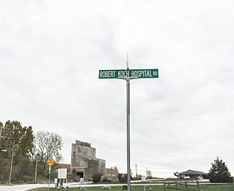
The intersection of Robert Koch Hospital Road and Koch Road in Oakville, Missouri. Near the previous site of Robert Koch Hospital. Photo taken in 2017.
|
|
| Lua error in Module:Location_map at line 420: attempt to index field 'wikibase' (a nil value). | |
| Nearest city | Oakville, Missouri |
|---|---|
| Built | 1907-1939 |
| Architect | E.E. Christopher, A.A Osburg |
| NRHP reference No. | 84000206 |
| Added to NRHP | October 31, 1984 |
Koch was a small community that used to exist in St. Louis County, Missouri. It was named after Robert Koch, a German scientist who studied tiny living things called bacteria. This area was located near what is now Interstate 255 and Route 231. The community even had its own post office, which is now closed.
The Robert Koch Hospital was a very important place located just off US 255. It was built by the city of St. Louis. Its main purpose was to care for patients with diseases that could easily spread. These included illnesses like smallpox, yellow fever, and tuberculosis.
Contents
The Robert Koch Hospital Story
The Robert Koch Hospital was founded in 1875. It was built to help control the spread of serious diseases. The hospital had its last major update in 1949. Sadly, the hospital building was taken down in 1989.
A Special Cemetery
There is a cemetery on the hospital grounds. It is known as the "Quarantine" cemetery. This cemetery is part of the 503 acres (2.04 km2) area that belonged to the hospital.
How the Hospital Grew
By 1939, nineteen buildings had been built at the hospital. The hospital also had a 105-acre (0.42 km2) farm. This farm helped the hospital grow its own food. It also had a post office, a train stop, housing for staff, and places for fun activities. All these things made the hospital almost able to support itself.
Changes Over Time
After World War II, new medicines were discovered. These medicines made diseases like tuberculosis much less dangerous. Because of this, the hospital's use changed. From the 1950s until 1983, it became a place for elderly people who needed housing. Today, the site also has an antenna for St. Louis City Emergency Management. The hospital site was added to the National Register of Historic Places in 1984. This means it was recognized as an important historical place.
Where Was Koch Located?
The Geographic Names Information System (GNIS) keeps records of places. It shows the historical coordinates for the Koch community. These are 38°28′54″N 90°17′08″W / 38.48172°N 90.28567°W.
GNIS also records the historical location of the Robert Koch Hospital. Its coordinates are 38°28′57″N 90°17′08″W / 38.48255°N 90.28567°W.
The exact location of the Koch post office is not known today.

