Kondut, Western Australia facts for kids
Quick facts for kids KondutWestern Australia |
|
|---|---|

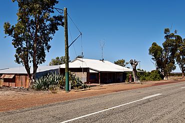
The former Kondut Post Office and Quarters, 2018
|
|
| Established | 1917 |
| Postcode(s) | 6605 |
| Elevation | 296 m (971 ft) |
| Area | [convert: needs a number] |
| Location |
|
| LGA(s) | Shire of Wongan-Ballidu |
| State electorate(s) | Moore |
| Federal Division(s) | Durack |
Kondut is a small, quiet town located in the Wheatbelt region of Western Australia. It's a place where farming is very important.
Kondut's Story: A Look Back
How Kondut Began
The first European to explore this area was a surveyor named C Crossland. He visited in 1884 and found a well nearby. He called it Conduit Well.
Kondut started as a railway siding in 1913. A railway siding is like a short extra track where trains can stop or wait. This siding was part of a bigger railway line. The line connected towns like Dowerin and Mullewa.
The town of Kondut was officially recognized in 1917. When a town is "gazetted," it means its boundaries and name are formally written down in government records.
What Happens in Kondut?
The land around Kondut is perfect for growing crops. Farmers in the area mainly produce wheat and other cereal crops. Cereals include grains like barley and oats.
Kondut is also a special "receival site" for a company called Cooperative Bulk Handling (CBH). This means it's a place where farmers bring their harvested grain. CBH then stores and transports the grain. It's a key part of getting food from farms to people.
 | Toni Morrison |
 | Barack Obama |
 | Martin Luther King Jr. |
 | Ralph Bunche |


