Shire of Wongan–Ballidu facts for kids
Quick facts for kids Shire of Wongan-BalliduWestern Australia |
|||||||||||||||
|---|---|---|---|---|---|---|---|---|---|---|---|---|---|---|---|

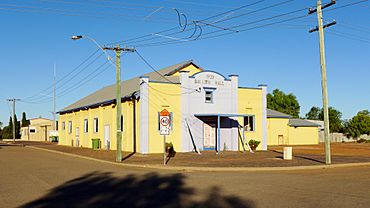
Ballidu Hall, 2014
|
|||||||||||||||

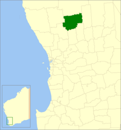
Location in Western Australia
|
|||||||||||||||
| Established | 1887 | ||||||||||||||
| Area | 3,368.7 km2 (1,300.7 sq mi) | ||||||||||||||
| Shire President | Mandy Stephenson | ||||||||||||||
| Council seat | Wongan Hills | ||||||||||||||
| Region | Wheatbelt | ||||||||||||||
| State electorate(s) | Moore | ||||||||||||||
| Federal Division(s) | Durack | ||||||||||||||
 |
|||||||||||||||
| Website | Shire of Wongan-Ballidu | ||||||||||||||
|
|||||||||||||||
The Shire of Wongan–Ballidu is a special area in Western Australia. It's like a local government, helping to run things for the people who live there. This Shire is located in the Wheatbelt region, which is known for farming. It's about 180 kilometers (112 miles) north-northeast of Perth, the capital city of Western Australia. The Shire covers a large area of about 3,369 square kilometers (1,301 square miles). The main town and where the local government offices are is called Wongan Hills. The Shire is also named after the Wongan Hills themselves!
Contents
A Look Back: How the Shire Started
The Shire of Wongan–Ballidu has an interesting history. It began a long time ago, on 10 February 1887. Back then, it was called the Melbourne Road District. Its job was to manage roads in the area.
Later, on 18 June 1926, its name changed to the Wongan-Ballidu Road District. Then, on 1 July 1961, something big happened. A new law called the Local Government Act 1960 changed all road districts into "shires." This meant they became full local government areas, just like they are today.
How the Shire is Run
The Shire of Wongan–Ballidu is managed by a group of people called councillors. As of May 3, 2003, there are ten councillors who help make decisions for the community.
The leader of the Shire is called the Shire President. This person is chosen directly by the people who live in the Shire, which means they get to vote for who they want to lead.
Towns and Communities
The Shire of Wongan–Ballidu is home to several towns and smaller communities. The main town is Wongan Hills, which is where most people live and where the Shire's offices are located.
Another important town is Ballidu. There are also smaller places like Burakin, Cadoux, and Kondut. Each of these places has its own unique feel and history within the Shire.
Past Towns
Some towns that used to exist in the Shire are no longer active communities today. One example is Kokardine.
How Many People Live Here?
The number of people living in the Shire of Wongan–Ballidu has changed over the years. In 1921, there were 666 people. The population grew quite a bit, reaching its highest point in 1966 with 2,333 people.
Since then, the population has slowly decreased. In 2021, the most recent count showed that 1,297 people lived in the Shire.
Special Places: Heritage Sites
The Shire of Wongan–Ballidu has many places that are important because of their history or special meaning. These are called heritage-listed places. As of 2023, there are 183 such places in the Shire!
Five of these places are considered so important that they are listed on the State Register of Heritage Places. This means they are officially recognized and protected for future generations to learn from and enjoy.
 | Bessie Coleman |
 | Spann Watson |
 | Jill E. Brown |
 | Sherman W. White |

