Shire of Victoria Plains facts for kids
Quick facts for kids Shire of Victoria PlainsWestern Australia |
|||||||||||||||
|---|---|---|---|---|---|---|---|---|---|---|---|---|---|---|---|

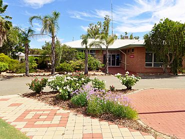
Victoria Plains shire offices, Calingiri, 2014
|
|||||||||||||||

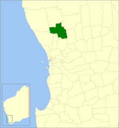
Location in Western Australia
|
|||||||||||||||
| Established | 1871 | ||||||||||||||
| Area | 2,569 km2 (991.9 sq mi) | ||||||||||||||
| Shire President | Pauline Bantock | ||||||||||||||
| Council seat | Calingiri | ||||||||||||||
| Region | Wheatbelt | ||||||||||||||
| State electorate(s) | Moore | ||||||||||||||
| Federal Division(s) | Durack | ||||||||||||||
 |
|||||||||||||||
| Website | Shire of Victoria Plains | ||||||||||||||
|
|||||||||||||||
The Shire of Victoria Plains is a special kind of local government area in Western Australia. It's located in the Wheatbelt region. This area is about 160 kilometers (100 miles) north of Perth, which is the capital city of Western Australia.
The Shire covers a large area of about 2,569 square kilometers (992 square miles). The main town and where the local government offices are located is Calingiri.
Contents
History of Victoria Plains
The story of the Shire of Victoria Plains began a long time ago. It started as the Victoria Plains Road District on January 24, 1871. Back then, it was much bigger than it is today. It stretched far north to a place called Carnamah. It even went all the way east to the border of South Australia.
Over the next 40 years, some parts of this big area started to form their own local governments. This meant they became separate from the Victoria Plains Road District.
For example, the Melbourne Road District became its own area on February 10, 1887. Later, on December 11, 1908, the Moora Road District also separated.
Finally, on July 1, 1961, a new law in Western Australia changed things. All the remaining "Road Districts" became known as "Shires." That's how the Victoria Plains Road District officially became the Shire of Victoria Plains.
Towns and Communities
The Shire of Victoria Plains is home to several small towns and communities. These places are where people live and work within the Shire. The main town and the center of the Shire's government is Calingiri. Other communities include Bolgart, New Norcia, and Yerecoin. Each of these places has its own unique feel and history.
Population Changes Over Time
The number of people living in the Shire of Victoria Plains has changed quite a bit over the years. Here's a look at how the population has grown and shrunk:
| Historical population | |||||||||||||||||||||||||||||||||||||||||||||||||||||||||||||
|---|---|---|---|---|---|---|---|---|---|---|---|---|---|---|---|---|---|---|---|---|---|---|---|---|---|---|---|---|---|---|---|---|---|---|---|---|---|---|---|---|---|---|---|---|---|---|---|---|---|---|---|---|---|---|---|---|---|---|---|---|---|
|
|
||||||||||||||||||||||||||||||||||||||||||||||||||||||||||||
As you can see, the population grew steadily for many years, reaching its highest point in 1961. Since then, the number of residents has slowly decreased. This kind of change is common in many rural areas.
Special Heritage Places
The Shire of Victoria Plains has many places that are important for their history and culture. These are called "heritage-listed places." As of 2023, there are 206 such places in the Shire.
Five of these places are extra special. They are listed on the State Register of Heritage Places. This means they are officially recognized as very important to the history of Western Australia. These sites are protected so future generations can learn from them.
 | Georgia Louise Harris Brown |
 | Julian Abele |
 | Norma Merrick Sklarek |
 | William Sidney Pittman |

