Kongiganak, Alaska facts for kids
Quick facts for kids
Kongiganak
Kangirnaq
|
|
|---|---|

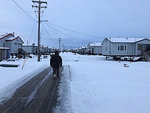
Many residents live in the newer "housing" section of town
|
|
| Country | United States |
| State | Alaska |
| Census Area | Bethel |
| Area | |
| • Total | 13.38 sq mi (34.65 km2) |
| • Land | 13.27 sq mi (34.36 km2) |
| • Water | 0.11 sq mi (0.29 km2) |
| Population
(2020)
|
|
| • Total | 486 |
| • Density | 36.63/sq mi (14.14/km2) |
| Time zone | UTC-9 (Alaska (AKST)) |
| • Summer (DST) | UTC-8 (AKDT) |
| ZIP code |
99545
|
| Area code(s) | 907 |
| FIPS code | 02-41610 |
Kongiganak (Central Yupik: Kangirnaq) is a small community in Alaska, United States. It is known as a census-designated place (CDP). This means it's a special area set up by the government for counting people. Kongiganak is mostly located on the eastern side of the Kongiganak River. In 2020, about 486 people lived there.
Contents
Where is Kongiganak?
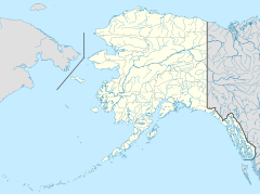
Kongiganak is located in the Bethel Census Area, Alaska. You can find it at these coordinates: 59°57′14″N 162°53′43″W / 59.95389°N 162.89528°W.
The community covers a total area of about 34.65 square kilometers (13.38 square miles). Most of this area is land, with a small part being water.
A Look at Kongiganak's Past
The very first settlement of Kongiganak was built in the 1800s. It was located near a small creek, just above Kuskokwim Bay. In 1880, this older site was called "Kongiganagamute." About 175 Inuit people lived there at that time. However, this original site was later abandoned. It was a few miles east of today's Kwigillingok and about 9 miles southeast of the current Kongiganak.
The Kongiganak we know today was settled permanently in the 1960s. People from a nearby community called Kwigillingok moved here. They were looking for higher ground to escape floods.
The community is served by its own airport, called Kongiganak Airport.
Who Lives in Kongiganak?
| Historical population | |||
|---|---|---|---|
| Census | Pop. | %± | |
| 1970 | 190 | — | |
| 1980 | 239 | 25.8% | |
| 1990 | 294 | 23.0% | |
| 2000 | 359 | 22.1% | |
| 2010 | 439 | 22.3% | |
| 2020 | 486 | 10.7% | |
| U.S. Decennial Census | |||
The current community of Kongiganak first appeared in the U.S. Census in 1970. Back then, it was listed as an unincorporated village. By 1980, it was officially called a census-designated place (CDP).
In 2000, there were 359 people living in Kongiganak. Most of the people were Native American, making up about 95.82% of the population. A small number were White or from two or more races.
Many households in Kongiganak have children. In 2000, about 55.7% of households had children under 18 living with them. The average household had about 4.54 people.
The population of Kongiganak is quite young. In 2000, about 43.2% of the people were under 18 years old. The average age was 22 years.
Learning in Kongiganak
Students in Kongiganak attend a school called Ayagina'ar Elitnaurvik. This school is part of the Lower Kuskokwim School District.
As of 2018, the school had 174 students. These students range from preschool all the way up to 12th grade. The school's mascot is the Wolverines!
See also
 In Spanish: Kongiganak (Alaska) para niños
 | Emma Amos |
 | Edward Mitchell Bannister |
 | Larry D. Alexander |
 | Ernie Barnes |


