Koppal facts for kids
Quick facts for kids
Koppal
Koppala
|
|
|---|---|
|
City
|
|

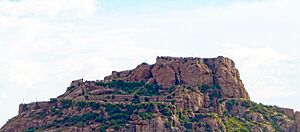
Koppal Fort
|
|
| Country | |
| State | Karnataka |
| Region | Kalyana-Karnataka |
| District | Koppal |
| Government | |
| • Type | City Municipality |
| Area | |
| • Total | 28.78 km2 (11.11 sq mi) |
| Elevation | 529 m (1,736 ft) |
| Population
(2011)
|
|
| • Total | 70,698 |
| • Density | 2,070.62/km2 (5,362.9/sq mi) |
| Languages | |
| • Official | Kannada |
| Time zone | UTC+5:30 (IST) |
| PIN |
583 231
|
| Telephone code | 08539 |
| Vehicle registration | KA-37 |
| Website | www.koppalcity.mrc.gov.in |
Koppal is a city in the Karnataka state of India. It is the main city and headquarters of the Koppal district. Imagine a city surrounded by hills on three sides – that's Koppal!
Long ago, Koppal was known by another name: Kopana Nagara. It is also famous for its history, especially for the Jain religion. People used to call it Jaina Kashi. This means it was a very sacred place for Jains, like a holy city. There were once more than 700 Basadis here. These were special halls for Jain meditation and prayer.
Koppal has important historical places. These include the strong Koppal Fort, the peaceful Gavimath (a religious shrine), and the Male Mallappa Temple. The Koppal district itself was created on April 1, 1998. It was formed from a part of the Raichur district.
Contents
People and Population in Koppal
Let's look at the people living in Koppal. According to a survey done in 2011, about 70,698 people lived in Koppal district. This number made it the 350th largest district in India at that time.
The district has about 250 people living in every square kilometer. Between 2001 and 2011, the number of people living here grew by about 16.32%. This means more people moved to Koppal or were born there during that time.
Koppal also has a good balance between boys and girls. For every 1000 boys, there were 1006 girls. This is called the sex ratio. Also, a lot of people in Koppal can read and write. About 79.97% of the people are literate. This means they have a good education.
Getting Around Koppal
Koppal is well-connected, making it easy to travel to and from the city.
Railway Connections
Koppal has its own railway station. It is located a little to the north-west of the city center. From this station, you can catch trains to many big cities. These include Delhi, Bengaluru, Hubli, Hyderabad, Tirupati, and Kolhapur.
Roadways and Highways
A major road called National Highway 63 goes right through Koppal. This highway connects two important places: Ankola and Gooty. It also passes through Hubli, another big city. This makes it easy for people to travel by car or bus.
Nearby Villages
Koppal district is home to many villages. Here are some of them:
- Bhatapanahalli
- Gangavathi
- Habalakatti
- Kuknur
- Kinhal
- Kushtagi
- Mandalagiri
- Tavaragera
- Yelburga
- Kesakkihanchinal
- Kanakagiri
See also
- In Spanish: Koppal para niños
 | Sharif Bey |
 | Hale Woodruff |
 | Richmond Barthé |
 | Purvis Young |


