
Koraleigh facts for kids
Quick facts for kids KoraleighNew South Wales |
|
|---|---|

Main street
|
|

Koraleigh
Location in New South Wales
|
|
| Population | 373 (2006 census) |
| Postcode(s) | 2735 |
| Location | |
| LGA(s) | Murray River Council |
| County | Wakool |
| State electorate(s) | Murray |
| Federal Division(s) | Farrer |
Koraleigh is a small village located in the western part of the Riverina region in New South Wales, Australia. It sits right on the Murray River. This village is part of the Murray River Council local government area.
Koraleigh is about 6 kilometers (4 miles) northeast of Nyah, Victoria. It is also about 15 kilometers (9 miles) south of Tooleybuc.
About Koraleigh
Koraleigh is built on the traditional lands of the Muthi Muthi Aboriginal tribe. The name "Koraleigh" comes from their language.
Population of Koraleigh
According to the 2006 census, Koraleigh had a population of 373 people. This number helps us understand how many people lived there at that time.
Koraleigh Post Office History
The Koraleigh Post Office first opened its doors on September 18, 1922. For many years, it was in a place called Eagles Lane. In the late 1980s, the Post Office moved. It became part of the only store in the town.
Gallery
-
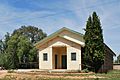
Public hall
-
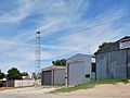
RFS shed
-
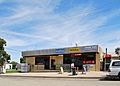
General store


