Kottayam district facts for kids
Kottayam District is one of the 14 districts in the state of Kerala, India. It is a very important area in Kerala. Interestingly, it is the only district that does not touch the Western Ghats mountains or the Arabian Sea.
The main town and headquarters of the district is Kottayam. This district is often called the "City of Three 'L's" because of its focus on Literacy, Lakes, and Latex (natural rubber). Kottayam was the first town in India to achieve a 100% literacy rate. Also, on September 27, 2008, Kottayam district became the first district in India to be declared tobacco-free.
Kottayam City is also known by other names. It's called Akshara Nagari, which means "City of Letters." It's also known as Chuvar Chitra Nagari, meaning "City of Mural Paintings."
The district has many special features. On its eastern side, it has hills. To the west, you'll find the beautiful Vembanad Lake and the green paddy fields of Kuttanad. Kottayam is famous for its wide backwater areas, rich rice fields, highlands, and many rubber plantations. These features give Kottayam District its special title: "The land of letters, legends, latex, and lakes." About 15% of the district is considered urban.
Two important religious groups in Kerala have their main offices in Kottayam District. These are the Nair Service Society and the Indian Orthodox Church.
People and Population
Let's look at the people living in Kottayam District. According to the 2011 census, about 1,979,384 people live here. This number is similar to the population of a country like Slovenia.
Kottayam is ranked 234th in population among all 640 districts in India. The district has many people living in a small area, with about 896 people per square kilometer. Between 2001 and 2011, the population grew by a small amount, about 1.32%.
Kottayam also has a good sex ratio. For every 1000 males, there are 1040 females. This shows a healthy balance. The district also has a very high literacy rate of 97.21%. This is the highest in Kerala and the fourth highest in all of India.
In 2001, the population of Kottayam included different religious groups. About 49.32% were Hindus, 44.60% were Christians, and 5.97% were Muslims.
Images for kids
-
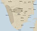
The area of the Chera dynasty in ancient times.
-
Kerala in the 11th century CE, marked as Chera.
-
A map of the Princely state of Travancore from 1871.
See also
 In Spanish: Distrito de Kottayam para niños
 | Delilah Pierce |
 | Gordon Parks |
 | Augusta Savage |
 | Charles Ethan Porter |


