Kulja, Western Australia facts for kids
Quick facts for kids KuljaWestern Australia |
|
|---|---|

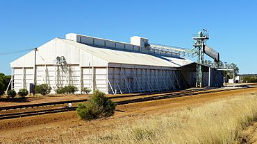
Kulja grain receival point, 2014
|
|
| Established | 1928 |
| Postcode(s) | 6470 |
| Elevation | 321 m (1,053 ft) |
| Area | [convert: needs a number] |
| Location |
|
| LGA(s) | Shire of Koorda |
| State electorate(s) | Central Wheatbelt |
| Federal Division(s) | Durack |
Kulja is a small town in the Wheatbelt region of Western Australia. This area is famous for growing many crops. The town is located along the road that connects Bonnie Rock and Burakin.
About Kulja
Kulja is a small community. It plays an important role in farming. The land around Kulja is used to grow wheat and other cereal crops. The town has a special site where farmers can deliver their harvested grain. This site is managed by Cooperative Bulk Handling (CBH).
History of Kulja
The area where Kulja is located was first mapped in 1908. Local Indigenous Australian people had a name for a nearby waterhole, which was "Kulja". This name was later given to the town.
Town Establishment
The town of Kulja was started in the late 1920s. It was built around a railway siding. A railway siding is a short track next to a main railway line. It is used for trains to stop or load goods. This siding was part of the Ejanding Northwards railway.
The town officially became a gazetted town in 1928. This happened after enough people had moved to the area.
Post Office and Grain Storage
Kulja had its own post office for many years. It operated from 1928 until 1973. There was also a temporary post office for railway construction workers. This one was open from 1929 to 1931.
In 1932, the Wheat Pool of Western Australia made an important announcement. They said that Kulja would get two new grain elevators. These elevators are tall structures used to store large amounts of grain. Each elevator had its own engine. They were built at the railway siding. This helped farmers store and transport their crops more easily.
 | Bessie Coleman |
 | Spann Watson |
 | Jill E. Brown |
 | Sherman W. White |


