Lüsslingen-Nennigkofen facts for kids
Quick facts for kids
Lüsslingen-Nennigkofen
|
||
|---|---|---|

Lüsslingen village church
|
||
|
||

Lüsslingen-Nennigkofen
Location in Switzerland

Lüsslingen-Nennigkofen
Location in Canton of Solothurn
|
||
| Country | Switzerland | |
| Canton | Solothurn | |
| District | Bucheggberg | |
| Area | ||
| • Total | 7.81 km2 (3.02 sq mi) | |
| Population
(Dec 2020 )
|
||
| • Total | 1,101 | |
| • Density | 140.97/km2 (365.1/sq mi) | |
| Postal code |
4574
|
|
| Surrounded by | Bellach, Biberist, Leuzigen (BE), Lohn-Ammannsegg, Lüterkofen-Ichertswil, Selzach | |

Lüsslingen-Nennigkofen is a town in Switzerland. It is located in the canton of Solothurn, within the Bucheggberg district. This town was formed on January 1, 2013. It happened when two smaller towns, Lüsslingen and Nennigkofen, joined together.
Contents
A Look Back in Time
The town of Lüsslingen has a long history. It was first written about in the year 1251. Back then, its name was in Luslingen.
Nennigkofen is also quite old. People first mentioned it in records in 1392. It was called Nennikofen or Nennikoven then.
Exploring the Geography


The total area of Lüsslingen-Nennigkofen is about 7.81 square kilometers. This is roughly 3 square miles.
Lüsslingen's Landscape
Lüsslingen covers an area of about 3.19 square kilometers. More than half of this land, about 55%, is used for farming. Forests cover about 26.6% of the area.
Around 12.5% of Lüsslingen has buildings or roads. A small part, 6.3%, is covered by rivers or lakes. The town is on the northern side of the Bucheggberg mountain. It is the closest town in the Bucheggberg district to the city of Solothurn.
Nennigkofen's Landscape
Nennigkofen has an area of about 4.62 square kilometers. Most of its land, about 64.3%, is used for farming. Forests make up about 24% of the area.
About 7.8% of Nennigkofen has buildings or roads. Rivers or lakes cover about 2.8% of the land. This part of the town is located in the Bucheggberger Aare valley.
Understanding the Climate
Lüsslingen-Nennigkofen has a mild climate. This means the temperatures are not too extreme. It also gets plenty of rain throughout the year. This type of weather is known as an "Oceanic climate" or "Marine West Coast Climate."
| Climate data for Lüsslingen-Nennigkofen (1981-2010) | |||||||||||||
|---|---|---|---|---|---|---|---|---|---|---|---|---|---|
| Month | Jan | Feb | Mar | Apr | May | Jun | Jul | Aug | Sep | Oct | Nov | Dec | Year |
| Mean daily maximum °C (°F) | 2.7 (36.9) |
4.8 (40.6) |
10.0 (50.0) |
14.1 (57.4) |
18.9 (66.0) |
22.4 (72.3) |
24.9 (76.8) |
24.2 (75.6) |
19.7 (67.5) |
14.3 (57.7) |
7.3 (45.1) |
3.5 (38.3) |
13.9 (57.0) |
| Daily mean °C (°F) | −0.2 (31.6) |
0.9 (33.6) |
5.1 (41.2) |
8.5 (47.3) |
13.2 (55.8) |
16.3 (61.3) |
18.6 (65.5) |
18.1 (64.6) |
14.2 (57.6) |
9.8 (49.6) |
4.0 (39.2) |
0.9 (33.6) |
9.1 (48.4) |
| Mean daily minimum °C (°F) | −2.9 (26.8) |
−2.7 (27.1) |
0.7 (33.3) |
3.4 (38.1) |
8.0 (46.4) |
11.2 (52.2) |
13.2 (55.8) |
12.9 (55.2) |
9.8 (49.6) |
6.2 (43.2) |
1.2 (34.2) |
−1.5 (29.3) |
5.0 (41.0) |
| Average precipitation mm (inches) | 71 (2.8) |
64 (2.5) |
75 (3.0) |
77 (3.0) |
110 (4.3) |
114 (4.5) |
105 (4.1) |
120 (4.7) |
97 (3.8) |
90 (3.5) |
77 (3.0) |
89 (3.5) |
1,088 (42.8) |
| Average snowfall cm (inches) | 16 (6.3) |
14.7 (5.8) |
7.7 (3.0) |
1.8 (0.7) |
0 (0) |
0 (0) |
0 (0) |
0 (0) |
0 (0) |
0.4 (0.2) |
5.7 (2.2) |
14.4 (5.7) |
60.7 (23.9) |
| Average precipitation days (≥ 1.0 mm) | 10.8 | 9.8 | 10.9 | 10.3 | 12.6 | 11.7 | 10.8 | 11.0 | 9.5 | 10.3 | 10.8 | 11.4 | 129.9 |
| Average snowy days (≥ 1.0 cm) | 4.7 | 4.2 | 2.6 | 0.7 | 0 | 0 | 0 | 0 | 0 | 0.1 | 1.5 | 3.4 | 17.2 |
| Average relative humidity (%) | 91.5 | 86.8 | 82.4 | 78.5 | 77.4 | 76.4 | 75.6 | 78.8 | 84.3 | 89.2 | 91.1 | 91.8 | 83.7 |
| Source: MeteoSwiss | |||||||||||||
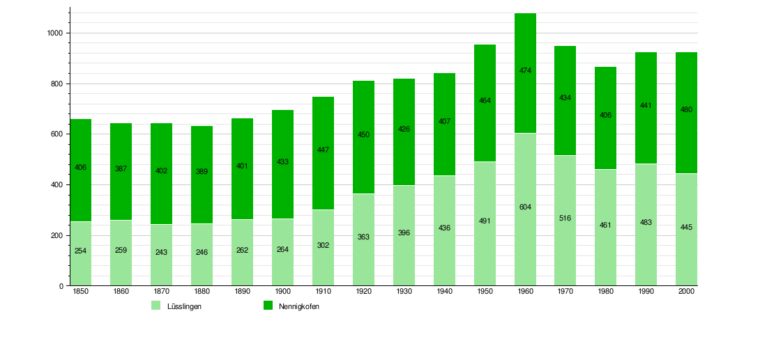
Population and People
The total number of people living in Lüsslingen-Nennigkofen is about 1,000. This number can change over time.
How the Population Has Changed
The chart below shows how the number of people living in Lüsslingen and Nennigkofen has changed over many years. You can see the population for each town separately.