
Solothurn (canton) facts for kids
Quick facts for kids
Solothurn
|
||
|---|---|---|
|
||
 |
||
| Capital | Solothurn | |
| Subdivisions | 126 municipalities, 10 districts | |
| Area | ||
| • Total | 791 km2 (305 sq mi) | |
| Area rank | 16th | |
| Population
(2006)
|
||
| • Total | 251,657 | |
| • Density | 318.15/km2 (824.0/sq mi) | |
| Highest point | 1,445 m (4,741 ft) - Hasenmatt | |
| Joined | 1481 | |
| Abbreviation | SO | |
| Languages | German | |
| Website | SO.ch | |

Solothurn is a canton in Switzerland. It is located in the northwest part of the country. The capital city is also called Solothurn.
Contents
Exploring Solothurn's Districts
Solothurn is divided into 10 smaller areas called districts. Each district helps manage the local communities.
- Bucheggberg, Amtei Wasseramt-Bucheggberg
- Dorneck, Amtei Dorneck-Thierstein (also known as Schwarzbubenland)
- Gäu, Amtei Thal-Gäu
- Gösgen, Amtei Olten-Gösgen (also known as Niederamt)
- Lebern, Amtei Solothurn-Lebern
- Olten, Amtei Olten-Gösgen
- Solothurn, Amtei Solothurn-Lebern
- Thal, Amtei Thal-Gäu
- Thierstein, Amtei Dorneck-Thierstein
- Wasseramt, Amtei Wasseramt-Bucheggberg
Towns and Villages (Municipalities)
Within these districts, there are 125 towns and villages. These are known as municipalities.
Images for kids
-
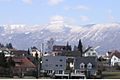
A view of Biberist

See also
 In Spanish: Cantón de Soleura para niños

All content from Kiddle encyclopedia articles (including the article images and facts) can be freely used under Attribution-ShareAlike license, unless stated otherwise. Cite this article:
Solothurn (canton) Facts for Kids. Kiddle Encyclopedia.