
Laupersdorf facts for kids
Quick facts for kids
Laupersdorf
|
||
|---|---|---|

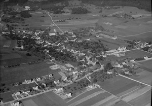
View of Laupersdorf from the hiking trail to Höngen (2016)
|
||
|
||

Laupersdorf
Location in Switzerland

Laupersdorf
Location in Canton of Solothurn
|
||
| Country | Switzerland | |
| Canton | Solothurn | |
| District | Thal | |
| Area | ||
| • Total | 15.5 km2 (6.0 sq mi) | |
| Elevation | 493 m (1,617 ft) | |
| Population
(Dec 2020 )
|
||
| • Total | 1,810 | |
| • Density | 116.8/km2 (302.4/sq mi) | |
| Postal code |
4712
|
|
| Surrounded by | Balsthal, Matzendorf, Mümliswil-Ramiswil, Niederbipp (BE), Wolfisberg (BE) | |

Laupersdorf is a small town, also called a municipality, in Switzerland. It is located in the Thal district within the Solothurn canton.
Contents
History of Laupersdorf
Laupersdorf was first mentioned in old writings way back in 968. At that time, it was called Luiperestorf. Later, in 1179, its name appeared as de Loppestorf. These old documents help us learn about the town's past.
Geography and Landscape

Laupersdorf covers an area of about 15.51 square kilometers (about 6 square miles). A big part of this land, almost half (47.5%), is used for farming. Another large part (46.6%) is covered by forests.
The town itself, with its buildings and roads, takes up about 5.8% of the land. A tiny bit (0.1%) is rivers or lakes. The rest is land that isn't used for farming or building.
Laupersdorf is in the Thal district, in a valley called Dünnern. It includes the main village of Laupersdorf, a smaller area called Höngen, and Änerholz, which has a few scattered houses. The town sits about 493 meters (1,617 feet) above sea level. It is located at the foot of the Brunnersberg mountain chain, which is part of the Jura Mountains.
Coat of Arms
The coat of arms for Laupersdorf is simple but unique. It shows a silver number 8 on a red background. This design is the official symbol of the town.
People and Population

Laupersdorf has a population of about 1,682 people. A small part of the population (9.7%) are people from other countries. Most people in Laupersdorf (93.5%) speak German. Other languages spoken include Serbo-Croatian and Albanian.
In 2008, the population was almost evenly split between males (49.9%) and females (50.1%). Many people (about 48.4%) were born in Laupersdorf and still live there. Others were born in the same canton or elsewhere in Switzerland.
The age groups in Laupersdorf show a good mix. About 9.1% of the population are young children (0-6 years old). Teenagers (7-19 years old) make up about 18.8%. Adults between 25 and 44 years old are the largest group, at 28.1%. There are also many older adults and seniors living in the town.
Most households in Laupersdorf have about 2.7 people. Many households are families with children. There are also single-person households and married couples without children.
The town has many single-family homes. Most of these homes were built after 1946. There are also some multi-family buildings and buildings used for both homes and businesses.
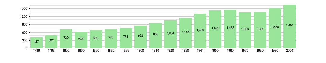
The population of Laupersdorf has changed over time. The chart below shows how the number of people living in the town has grown through the years.
Important Sights
The entire area of Höngen, which is part of Laupersdorf, is listed as an Inventory of Swiss Heritage Site. This means it's a special place with important historical or cultural value that is protected.
Economy and Jobs
In 2010, the unemployment rate in Laupersdorf was 3.1%. This means most people who wanted jobs had them. Many people in Laupersdorf work in different types of jobs:
- Primary sector: About 90 people work in this sector. This includes jobs like farming and forestry.
- Secondary sector: About 145 people work here. These jobs involve making things, like in factories (manufacturing) or building things (construction).
- Tertiary sector: About 103 people work in this sector. These are service jobs, such as working in shops, restaurants, education, or healthcare.
Many residents of Laupersdorf travel to other towns for work. About 63.7% of working people use a private car to get to their jobs. About 11.9% use public transportation.
Religion in Laupersdorf
According to a census in 2000, most people in Laupersdorf (72.0%) are Roman Catholic. About 15.5% belong to the Swiss Reformed Church. There are also smaller groups of people who follow other Christian churches or Islam. Some people do not belong to any church.
Education and Schools

Many adults in Laupersdorf have completed their education. About 39.2% have finished upper secondary education, which is like high school. About 5.8% have gone on to higher education, like university.
The school system in Solothurn canton starts with two years of non-required Kindergarten. In 2010-2011, 34 children were in kindergarten in Laupersdorf. After that, students attend six years of primary school. Laupersdorf had 124 primary school students. For secondary school, students from Laupersdorf go to schools in nearby towns.
Laupersdorf also has its own public library, called the Schul- und Gemeindebibliothek Laupersdorf. In 2008, it had over 6,900 books and other media. It loaned out more than 15,000 items that year.
Getting Around (Transports)
Laupersdorf is easy to reach because a main road connecting Oensingen to Moutier passes through it. The town also has a public transport line with three different stops, making it convenient for people to travel without a car.
See also
 In Spanish: Laupersdorf para niños
