
Recherswil facts for kids
Quick facts for kids
Recherswil
|
||
|---|---|---|

Recherswil village
|
||
|
||

Recherswil
Location in Switzerland

Recherswil
Location in Canton of Solothurn
|
||
| Country | Switzerland | |
| Canton | Solothurn | |
| District | Wasseramt | |
| Area | ||
| • Total | 3.36 km2 (1.30 sq mi) | |
| Elevation | 458 m (1,503 ft) | |
| Population
(Dec 2020 )
|
||
| • Total | 2,028 | |
| • Density | 603.6/km2 (1,563.2/sq mi) | |
| Postal code |
4565
|
|
| Surrounded by | Halten, Heinrichswil-Winistorf, Koppigen (BE), Kriegstetten, Obergerlafingen, Willadingen (BE) | |

Recherswil is a small town, also called a municipality, located in the Wasseramt district. It is part of the canton of Solothurn in Switzerland. This charming place is known for its peaceful setting.
Contents
Discovering Recherswil's Past
Recherswil has a long history. It was first mentioned in official records way back in 1278. At that time, its name was written as Richirswile.
Exploring Recherswil's Geography

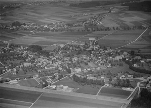
Recherswil covers an area of about 3.37 square kilometers (1.3 square miles). A large part of this land, about 55.2%, is used for farming. Forests cover another 22.0% of the area.
About 20.8% of Recherswil is built up with buildings and roads. A very small part, 0.3%, is made up of rivers or lakes. The municipality is located between two rivers, the Emme and the Oesch.
Understanding Recherswil's Coat of Arms
Every town has a special symbol called a coat of arms. Recherswil's coat of arms is described as Gules a Ploughshare Sable between two Mullets Or in chief. This means it has a red background. On it, there is a black plowshare, which is the cutting part of a plow. Above the plowshare, there are two golden stars.
Recherswil's Population and People
Recherswil has a population of about 1,800 people. Most people in Recherswil speak German. About 95.7% of the residents use German as their main language.
Other languages spoken include Italian (2.1%) and Serbo-Croatian (0.6%). A small number of people also speak French or Romansh.
Many people living in Recherswil were born there or in the same canton. About 28.5% of the population in 2000 were born in Recherswil. Another 29.5% were born in the same canton, Solothurn.
The age groups in Recherswil are quite varied. In 2000, about 6.3% of the population were children aged 0 to 6 years old. Teenagers, aged 7 to 19, made up about 18.3% of the population.
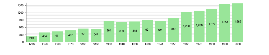
The chart below shows how Recherswil's population has grown over time:
Recherswil's Economy and Jobs
Recherswil has a mix of different jobs. In 2008, there were 40 people working in the primary economic sector, which includes farming. There were 10 businesses in this area.
The secondary sector, which includes manufacturing and construction, employed 101 people. This sector had 26 businesses. The tertiary sector, which covers services like sales, transport, and education, employed 134 people. There were 38 businesses in this sector.
Many people who live in Recherswil travel to other towns for work. In 2000, about 151 workers came into Recherswil for jobs. However, 702 workers left Recherswil to work elsewhere. Most people (63.5%) used a private car to get to work. About 13.9% used public transportation.
Religion in Recherswil
In 2000, people in Recherswil followed various religions. About 32.9% were Roman Catholic. Another 43.5% belonged to the Swiss Reformed Church.
Some people were part of other Christian churches, like Orthodox or Christian Catholic. About 1.95% of the population were Islamic. A small number were Buddhist or belonged to other faiths. About 16.08% of the population did not belong to any church.
Education in Recherswil
Education is important in Recherswil. In 2000, about 41.9% of the population had finished upper secondary education. This is education after primary school.
About 9.8% of the population had gone on to higher education. This means they attended a university or a specialized college (a Fachhochschule).
In 2000, 21 students came to Recherswil for school from other towns. At the same time, 111 students from Recherswil went to schools outside the municipality.
Images for kids
-
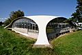
The Isler shell, a unique concrete dome roof in Recherswil

See also
 In Spanish: Recherswil para niños
