
Koppigen facts for kids
Quick facts for kids
Koppigen
|
||
|---|---|---|

Former Gasthof Bären in St Niklaus hamlet
|
||
|
||

Koppigen
Location in Switzerland

Koppigen
Location in Canton of Bern
|
||
| Country | Switzerland | |
| Canton | Bern | |
| District | Emmental | |
| Area | ||
| • Total | 6.93 km2 (2.68 sq mi) | |
| Elevation | 476 m (1,562 ft) | |
| Population
(Dec 2020 )
|
||
| • Total | 2,104 | |
| • Density | 303.61/km2 (786.3/sq mi) | |
| Postal code |
3425
|
|
| Surrounded by | Alchenstorf, Höchstetten, Niederösch, Obergerlafingen (SO), Recherswil (SO), Utzenstorf, Willadingen, Zielebach | |

Koppigen is a town, also called a municipality, located in the Emmental area of the Bern canton in Switzerland. It's a cool place with a long history!
Contents
History of Koppigen
Koppigen was first mentioned in old writings way back in 1139. It was called Chopingen around 1181-82. Later, in 1887, a small part of Koppigen called Brechershäusern became part of the nearby village of Wynigen.
Early Settlements
People have lived in the Koppigen area for a very long time. Tools and items from the Neolithic (New Stone Age) have been found here. There are also discoveries from the Bronze Age and a special burial mound from the Hallstatt culture.
The village church and its parsonage (the home for the church leader) were built on top of an old Roman-era farmhouse. Other Roman sites have also been found around the town.
Koppigen Castle and Lords
During the Middle Ages, Koppigen was built around a castle. The knights who served the powerful House of Zähringen family lived here. These knights were called the Koppigen family. They were first mentioned in 1181 but their family line ended in 1276.
After that, the castle and lands were owned by different noble families. By the 1300s, they belonged to the Lords of Thornberg.
The Battle of Sempach and Bern's Influence
In 1386, a lord named Peter of Thornberg supported the Habsburgs against the city of Bern during the Battle of Sempach. Because of this, soldiers from Bern attacked Koppigen Castle and burned it down!
In 1397, Peter of Thornberg passed away. He left all his land in Koppigen to a new monastery he had started, called the Carthusian Charterhouse of Thornberg. This monastery made Koppigen the center for several nearby villages.
After the Protestant Reformation in 1528, Bern took over the monastery's lands. Bern then put a special officer, called a vogt, in charge of Koppigen. It became part of the Burgdorf district.
Old Resting Places and Inns
Two nearby villages, Öschberg/Öschfurt and St. Niklaus, were important stops along an old east-west road. St. Niklaus got its name from a chapel built there before 1448.
In 1448, the monastery set up a hostel (like a hotel) in St. Niklaus. The person running the hostel also had to take care of the chapel. They also opened a hostel in Öschberg.
After the Reformation, these hostels became taverns and inns. The St. Niklaus hostel, called Gasthof Bären, later became a boys' boarding school in 1924. Today, it's a children's home called Friedau. The Öschberg hostel, Gasthof Sonne, became a workhouse and a model farm in 1906.
Modern Changes
In the early 1800s, farmers in Koppigen changed from growing grain to raising dairy cattle and hay. The first dairy in the town opened in 1844. Another one opened in St. Niklaus in 1867.
In the 1870s, Koppigen started to get more industries, like a cigar factory. Today, the town has smaller businesses in manufacturing, construction, car parts, and making special small metal parts.
Koppigen is also a center for schools in the region. Until 1821, it had the only school for the whole area. A secondary school opened in Koppigen in 1891. In 1920, a special foundation started a regional horticulture (gardening) school here. It also became a national center for growing special crops.
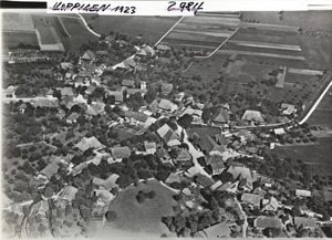
Geography
_142.JPG)
Koppigen covers an area of about 6.98 square kilometers (2.69 square miles). A large part of this land, about 58.9%, is used for farming. Forests cover about 23.1% of the area.
About 17.2% of Koppigen is covered by buildings and roads. A small part, 0.6%, is rivers or lakes, and 0.1% is land that can't be used for anything.
Most of the built-up areas are homes and buildings (6.8%), roads (6.3%), and industrial buildings (1.4%). There are also parks and sports fields (1.6%). All the forests in Koppigen are dense, thick woods.
For farming, 47.5% of the land is used for growing crops. Another 9.2% is used for pastures where animals graze. A small part, 2.2%, is used for orchards or vineyards. All the water in Koppigen comes from flowing rivers.
Koppigen is located on the banks of the Ösch River. It includes the main town of Koppigen and the smaller settlements of St. Niklaus and Öschberg. It also serves as the main church area for nearby towns like Alchenstorf, Hellsau, Höchstetten, and Willadingen.
In 2010, Koppigen became part of a new administrative district called Verwaltungskreis Emmental.
Coat of Arms
The official symbol, or blazon, of Koppigen's coat of arms is a red shield with a white rooster on it.
Demographics
Koppigen has a population of about 2,200 people. In 2010, about 7.1% of the people living here were from other countries. Over the past 10 years (2000-2010), the population grew by about 8.3%. Most of this growth was from people moving into Koppigen.
Languages Spoken
In 2000, most people in Koppigen (94.5%) spoke German as their main language. The second most common language was Albanian (1.2%), followed by Serbo-Croatian (0.8%). A few people also spoke French, Italian, or Romansh.
Population Details
In 2008, about 48.4% of the population was male and 51.6% was female. Most people were Swiss citizens.
In 2000, about 32.5% of the people living in Koppigen were born there. Another 40% were born in the same canton (Bern). About 14.4% were born elsewhere in Switzerland, and 7.8% were born outside of Switzerland.
In 2010, children and teenagers (ages 0-19) made up 22.5% of the population. Adults (20-64) made up 62.3%, and seniors (over 64) made up 15.1%.
Family Life
In 2000, about 897 people in Koppigen were single and had never been married. There were 960 married people, 151 widows or widowers, and 58 divorced people.
There were 206 households with only one person and 60 households with five or more people. Most apartments (92.9%) were lived in all the time. In 2010, new homes were being built at a rate of 1.9 new units per 1000 residents.
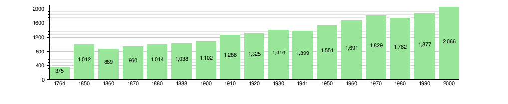
The historical population of Koppigen is shown in this chart:
Important Historical Buildings

The old Gasthof Bären (an inn and restaurant) and its other buildings in the small village of St. Niklaus are very important. They are listed as a Swiss heritage site of national significance. This means they are protected because of their historical value.
The main Gasthof building was built in 1824. It shows styles from the late Baroque and Neoclassical periods. The part of the building where people lived was built in the late 1700s. In 1924, these buildings were used as a home for boys.
Economy
In 2011, Koppigen had a low unemployment rate of 2.1%. This means most people who wanted jobs had them. In 2008, 773 people worked in Koppigen.
Job Sectors
Jobs are often grouped into three main types:
- Primary sector: This includes jobs that get raw materials from nature, like farming. In Koppigen, 67 people worked in this sector, mostly in agriculture.
- Secondary sector: This includes jobs that make things, like factories and construction. There were 176 people working in this sector. About half worked in manufacturing and half in construction.
- Tertiary sector: This includes jobs that provide services, like shops, schools, and healthcare. In Koppigen, 530 people worked in this sector. Many worked in sales, transportation, hotels, finance, education, and healthcare.
Commuting
In 2000, 426 workers traveled into Koppigen for their jobs. However, 644 workers from Koppigen traveled to other towns for work. This means more people leave Koppigen to work than come in.
About 9.3% of working people used public transportation (like buses or trains) to get to work. Most people, 56.6%, used a private car.
Religion
Based on a 2000 survey, most people in Koppigen (80.1%) belonged to the Swiss Reformed Church (a type of Protestant church). About 8.9% were Roman Catholic.
There were also smaller groups of people who belonged to other Christian churches (3.39%), Islamic (2.42%), Buddhist, or Hindu faiths. About 3.39% of the population said they didn't belong to any church or were agnostic or atheist.
Education
In Koppigen, about 37.4% of the people have finished high school (called non-mandatory upper secondary education in Switzerland). About 10.7% have gone on to higher education, like university.
School System
The school system in the Canton of Bern works like this:
- One year of optional Kindergarten.
- Six years of Primary school.
- Three years of required Lower Secondary school. In this stage, students are grouped based on their abilities.
After Lower Secondary, students can choose to continue their education or start an apprenticeship (learning a trade on the job).
Student Numbers
During the 2010-2011 school year, 372 students attended classes in Koppigen.
- There were 3 kindergarten classes with 57 students.
- There were 9 primary classes with 169 students.
- There were 8 lower secondary classes with 146 students.
In 2000, 76 students came to Koppigen schools from other towns. At the same time, 67 students from Koppigen went to schools outside the town.
Library
Koppigen has its own public library, called the Schul- und Gemeindebibliothek Koppigen. In 2008, the library had 6,777 books and other media. They loaned out 18,865 items that year. The library was open for 160 days, averaging 6 hours per week.
Climate
| Climate data for Koppigen (1991–2020) | |||||||||||||
|---|---|---|---|---|---|---|---|---|---|---|---|---|---|
| Month | Jan | Feb | Mar | Apr | May | Jun | Jul | Aug | Sep | Oct | Nov | Dec | Year |
| Mean daily maximum °C (°F) | 3.1 (37.6) |
5.2 (41.4) |
10.5 (50.9) |
14.9 (58.8) |
18.9 (66.0) |
22.9 (73.2) |
25.1 (77.2) |
24.6 (76.3) |
19.7 (67.5) |
14.1 (57.4) |
7.5 (45.5) |
3.5 (38.3) |
14.2 (57.6) |
| Daily mean °C (°F) | 0.4 (32.7) |
1.1 (34.0) |
5.2 (41.4) |
8.9 (48.0) |
13.2 (55.8) |
16.8 (62.2) |
18.7 (65.7) |
18.4 (65.1) |
14.0 (57.2) |
9.5 (49.1) |
4.3 (39.7) |
1.0 (33.8) |
9.3 (48.7) |
| Mean daily minimum °C (°F) | −2.7 (27.1) |
−2.8 (27.0) |
0.3 (32.5) |
3.1 (37.6) |
7.5 (45.5) |
11.1 (52.0) |
12.8 (55.0) |
12.7 (54.9) |
9.2 (48.6) |
5.6 (42.1) |
1.2 (34.2) |
−1.8 (28.8) |
4.7 (40.5) |
| Average precipitation mm (inches) | 65 (2.6) |
57 (2.2) |
63 (2.5) |
76 (3.0) |
105 (4.1) |
107 (4.2) |
107 (4.2) |
115 (4.5) |
85 (3.3) |
86 (3.4) |
77 (3.0) |
85 (3.3) |
1,026 (40.4) |
| Average snowfall cm (inches) | 11 (4.3) |
12 (4.7) |
5 (2.0) |
2 (0.8) |
0 (0) |
0 (0) |
0 (0) |
0 (0) |
0 (0) |
1 (0.4) |
5 (2.0) |
14 (5.5) |
50 (20) |
| Average precipitation days (≥ 1.0 mm) | 10.1 | 9.3 | 9.5 | 9.5 | 11.9 | 11.4 | 10.8 | 11.2 | 9.1 | 10.3 | 10.6 | 11.4 | 125.1 |
| Average snowy days (≥ 1.0 cm) | 3.6 | 3.3 | 1.7 | 0.6 | 0.0 | 0.0 | 0.0 | 0.0 | 0.0 | 0.1 | 1.2 | 3.3 | 13.8 |
| Average relative humidity (%) | 86 | 81 | 75 | 73 | 74 | 73 | 71 | 74 | 79 | 85 | 88 | 88 | 79 |
| Source: MeteoSwiss | |||||||||||||
See also
 In Spanish: Koppigen para niños
