
Wynigen facts for kids
Quick facts for kids
Wynigen
|
||
|---|---|---|

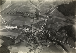
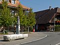
Farmhouse Glugge and manor house in Wynigen village
|
||
|
||

Wynigen
Location in Switzerland

Wynigen
Location in Canton of Bern
|
||
| Country | Switzerland | |
| Canton | Bern | |
| District | Emmental | |
| Area | ||
| • Total | 28.32 km2 (10.93 sq mi) | |
| Elevation | 530 m (1,740 ft) | |
| Highest elevation | 850 m (2,790 ft) | |
| Lowest elevation | 500 m (1,600 ft) | |
| Population
(Dec 2020 )
|
||
| • Total | 2,077 | |
| • Density | 73.340/km2 (189.95/sq mi) | |
| Postal code |
3472
|
|
| Surrounded by | Affoltern im Emmental, Alchenstorf, Burgdorf, Ersigen, Heimiswil, Kirchberg, Ochlenberg, Oeschenbach, Rumendingen, Walterswil | |

Wynigen is a small town, also called a municipality, located in the Emmental area of Switzerland. It's part of the canton of Bern.
Contents
- Wynigen's Past: A Look at History
- Wynigen's Location: Geography and Landscape
- Wynigen's Symbol: Coat of Arms
- Who Lives in Wynigen: Demographics
- Important Buildings: Heritage Sites
- Working in Wynigen: Economy
- Beliefs in Wynigen: Religion
- Learning in Wynigen: Education
- Getting Around: Transportation
- Famous People from Wynigen
- See also
Wynigen's Past: A Look at History
Wynigen was first written about in the year 1185. Another nearby village, Bickigen, was mentioned a bit later, around 1261-1263.
Early Settlements and Forts
People lived in this area a very long time ago. We know this from ancient burial mounds found on Füstlenberg hill. There are also graves from the La Tène culture in Bickigen. Other signs of old settlements include earth walls at Heidenstatt. There were also old forts at Grimmenstein, Friesenberg, and Schwanden.
Medieval Times and Powerful Families
When Wynigen was first mentioned, it belonged to the Zähringen Dukes. After their family line ended in 1218, the land went to the Counts of Kyburg. By 1261-1263, Wynigen was part of a special area called officium Gutisberg.
Some important families, like the Lords of Wynigen, built castles here. They helped protect the Kyburg lands. Over time, these families became citizens of Bern or Thun. They lost their lands that were given to them by the Kyburgs. By the 14th century, these families had died out.
Wars and Changes in Control
During the Burgdorf War (1383-1384), the Counts of Kyburg fought against the city of Bern. The Counts lost all their land in Wynigen. Bern attacked and destroyed the Friesenberg castle. The Grimmenstein Castle surrendered to Bern.
In 1402, the Kyburgs had to sell some of their land to Burgdorf. Bern officially took over the villages in 1406. They became part of the County of Wangen. Later, in 1431, Wynigen moved to the Burgdorf District. In 1497, Bern bought the main estate of Wynigen and Grimmenstein Castle. A few years later, the villages and castle were given to the Bernese mayor of Burgdorf.
The Village Church and Farming Life
The village church was first mentioned in 1275. The original church was replaced in the 16th century, and then rebuilt again in 1671. There was also a chapel at Friesenberg Castle. This chapel was a separate church for its own area until after the Protestant Reformation. After that, it was left empty and fell apart.
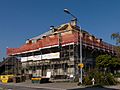
By the 13th or 14th century, there were many large farms around Wynigen. These farms grew crops and raised animals. Even with good roads and a train station, Wynigen stayed mostly a farming area. Most factories that tried to open here either moved or closed down. The only successful businesses were dairy factories. They made cheese from milk from local farms.
Schools in Wynigen
Wynigen has had a secondary school since 1835. The school district includes Wynigen, Kappelen, Mistelberg, and Rüedisbach. However, because fewer students were enrolling, only the schools in Wynigen and Kappelen stayed open after 2007.
Bickigen-Schwanden and Brechershäusern
In 1550, Bickigen village had only a few farmhouses. By 1764, Bickigen and Schwanden had 106 people. In 1832, these two villages became their own municipality called Bickigen-Schwanden. But they didn't stay independent for long. In 1911, their 147 residents joined Wynigen. In 1928, a power company built a large electrical station in Bickigen. This station is an important part of the power grid in Switzerland and Europe.
Brechershäusern was a small group of houses that was not part of the Kyburg area. Its residents were citizens of Burgdorf. In 1312, they gave some land to Fraubrunnen Abbey. Until 1887, Brechershäusern and other small areas were part of the Koppigen church area. They were like a small island inside Wynigen. In 1880, these small areas became their own municipality with 118 people.
Wynigen's Location: Geography and Landscape
Wynigen covers an area of about 28 square kilometers (10.8 square miles). A large part of this land, about 56.6%, is used for farming. About 37.4% of the area is covered by forests. The rest of the land, about 5.6%, has buildings or roads. A very small part, 0.2%, is rivers or lakes.
Most of the built-up area is made of houses and other buildings (2.7%). Roads and other transport paths make up 2.4%. In the forested areas, 35.5% is dense forest. Another 1.8% has orchards or small groups of trees. For farming, 21.3% is used for growing crops. Pastures for animals make up 33.7%. About 1.7% is used for fruit trees or grapevines. All the water in Wynigen is flowing water, like rivers.
Wynigen is located in the hilly area of Emmental. Its elevation ranges from about 500 to 849 meters (1,640 to 2,785 feet) above sea level. The municipality includes the main villages of Wynigen and Bickigen-Schwanden. It also has smaller groups of houses, called hamlets, like Rüedisbach, Kappelen, Mistelberg, Ferrenberg, Breitenegg, and Brechershäusern. There are also many scattered farmhouses.
On December 31, 2009, the old district of Burgdorf was closed. The next day, Wynigen joined the new Emmental district.
Wynigen's Symbol: Coat of Arms
The coat of arms for Wynigen is a shield that is split diagonally. One part is silver with a red rose. The other part is red.
Who Lives in Wynigen: Demographics
Wynigen has a population of about 2,000 people. In 2010, a small part of the population, about 2.3%, were people from other countries. Over the past 10 years (2000-2010), the population has slightly decreased.
Most people in Wynigen (about 97.8%) speak German as their main language. A small number of people speak Albanian or French.
In 2008, about 49.1% of the population was male and 50.9% was female. Most people in Wynigen were born there or in the same canton.
In 2010, children and teenagers (ages 0-19) made up about 22.9% of the population. Adults (ages 20-64) made up 59.1%. Seniors (over 64 years old) made up 17.9%.
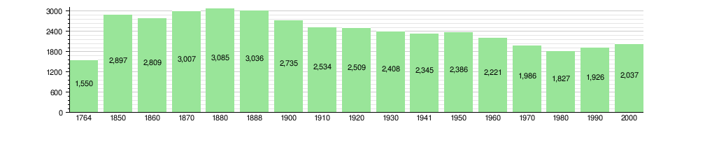
Population Changes Over Time
The chart below shows how Wynigen's population has changed through history:
Important Buildings: Heritage Sites
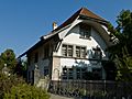
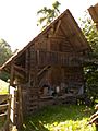
Several buildings in Wynigen are considered very important historical sites in Switzerland. These include:
- The farmhouse at Oberbühl 239.
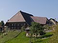
- The farmhouse called Glungge at Brechershäusern 340.
- The village fountain.
- The old gasthof (inn) called Wilder Mann.
- The village rectory (the house where a priest lives).
- The granary (a building for storing grain) in Oberbüel.
The entire small area of Breitenegg is also part of a special list of Swiss heritage sites.
-
Farm House at Oberbühl 239
-
Farm House Glungge at Brechershäusern 340
-
Village fountain
-
Former Gasthof Wilder Mann
-
Rectory
-
Granary in Oberbüel


Working in Wynigen: Economy
In 2011, Wynigen had a low unemployment rate of 1.17%. In 2008, there were 682 people working in the municipality.
Types of Jobs
- Primary Sector: About 323 people worked in farming, forestry, and fishing. There were 114 businesses in this area.
- Secondary Sector: About 123 people worked in manufacturing and construction. There were 29 businesses in this area.
- Tertiary Sector: About 236 people worked in services, like shops, hotels, and schools. There were 41 businesses in this area.
Many people who live in Wynigen travel to other towns for work. In 2000, 190 workers came into Wynigen, but 638 workers left to work elsewhere. About 13.1% of working people used public transport, and 49.7% used a private car to get to work.
Beliefs in Wynigen: Religion
Based on the 2000 census, most people in Wynigen (about 82.7%) belonged to the Swiss Reformed Church. About 4.3% were Roman Catholic. A small number of people belonged to other Christian churches or were Islamic. Some people did not belong to any church.
Learning in Wynigen: Education
In Wynigen, about 40.3% of the population has finished high school. About 8.2% have gone on to higher education, like university.
School System
The Bern school system starts with one year of optional Kindergarten. Then, students go to six years of Primary school. After that, there are three years of mandatory lower Secondary school. Students are grouped based on their abilities. After lower Secondary, students can continue their education or start an apprenticeship.
During the 2010-2011 school year, 288 students attended classes in Wynigen. There were 46 kindergarten students, 121 primary students, and 121 lower secondary students.
Wynigen has a public library called Schul- und Gemeindebibliothek Wynigen. In 2008, it was open 256 days a year, for about 5.5 hours per week.
Getting Around: Transportation
Wynigen has a train station called Wynigen. It is on the line that connects Olten and Bern. You can take a train from Wynigen to both Bern and Olten regularly.
Famous People from Wynigen
- Rudolf Sutermeister (born May 7, 1802) was a socialist, writer, doctor, and businessman.
See also
 In Spanish: Wynigen para niños
