
Rumendingen facts for kids
Quick facts for kids
Rumendingen
|
||
|---|---|---|
_141.jpg)
Aerial view of Rumendingen village and surroundings
|
||
|
||

Rumendingen
Location in Switzerland

Rumendingen
Location in Canton of Bern
|
||
| Country | Switzerland | |
| Canton | Bern | |
| District | Emmental | |
| Area | ||
| • Total | 2.44 km2 (0.94 sq mi) | |
| Elevation | 526 m (1,726 ft) | |
| Population
(Dec 2020 )
|
||
| • Total | 81 | |
| • Density | 33.20/km2 (86.0/sq mi) | |
| Postal code |
3472
|
|
| Surrounded by | Alchenstorf, Ersigen, Niederösch, Oberösch, Wynigen | |

Rumendingen is a small town, also known as a municipality, located in the Emmental area of Switzerland. It's part of the Bern canton, which is like a state or region in Switzerland.
Contents
History of Rumendingen
Rumendingen was first mentioned in old records way back in the year 886. Back then, it was called Rumaningun.
For a long time, Rumendingen was part of a larger area called Niederösch. It even shared farming fields with the nearby village of Wynigen. In 1660, sharing these fields caused some arguments between the two villages. Over 100 years later, in 1777, the fields were finally divided fairly between them.
Until 1953, people from Rumendingen went to church in Kirchberg. After that, they joined the church community in Wynigen. Starting in the 1800s, Rumendingen also became part of the Wynigen school district.
In the early 1900s, most people in Rumendingen worked in farming. Later, a business for storing goods opened from 1941 to 1965. A small gravel mine also started in 1963, giving some jobs to local people. In 1914, a special place called Karolinenheim was given to the community. Today, it's a home and workshop for young people with disabilities.
Geography and Landscape
Rumendingen covers an area of about 2.5 square kilometers (about 1 square mile). A big part of this land, about 60%, is used for farming. Forests cover about 31% of the area. The rest, about 8.6%, has buildings and roads. A small part, 1.6%, is rivers or lakes.
Most of the built-up areas are homes and other buildings. Roads and transportation also take up some space. All the forests in Rumendingen are thick, natural forests. The farming land is used for growing crops and for pastures where animals graze. All the water in the municipality comes from flowing rivers or streams.
The town is located in a valley called the Känerich valley. In 2010, Rumendingen became part of a new administrative area called Verwaltungskreis Emmental.
Rumendingen's Coat of Arms
The coat of arms for Rumendingen has a special design. It is split diagonally into two colors: red and silver. On this design, you can see two clover-like shapes called "trefoils." One trefoil is red on the silver side, and the other is silver on the red side. This design is called Per bend Gules and Argent two Trefoils counterchanged.
Population and People
Rumendingen has a small population. As of 2010, about 1.3% of the people living there were from other countries. Over the past 10 years (from 2000 to 2010), the number of people living in Rumendingen went down by about 17.7%.
Most people in Rumendingen speak German as their main language. A very small number of people speak French or Spanish.
In 2008, a little more than half of the population (51.9%) were men, and a little less than half (48.1%) were women. Most of the people living in Rumendingen were born in Switzerland.
As of 2010, children and teenagers (up to 19 years old) make up about 16.5% of the population. Adults (20 to 64 years old) make up about 59.5%, and seniors (over 64 years old) make up about 24.1%.
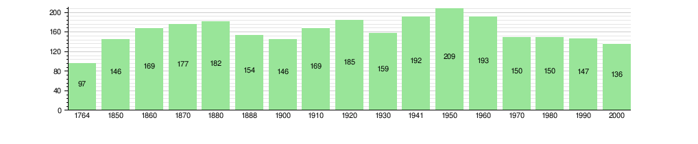
The chart below shows how the population of Rumendingen has changed over many years:
Important Sights
The entire village of Rumendingen is considered a special place. It is listed as part of the Inventory of Swiss Heritage Sites, which means it's important to protect its history and beauty.
Economy and Jobs
In 2011, Rumendingen had a very low unemployment rate, meaning almost everyone who wanted a job had one. In 2008, there were 96 people working in the municipality.
- Many people (28) worked in the primary economic sector, which mainly means farming. There were about 10 businesses related to farming.
- Some people (21) worked in the secondary sector, which includes things like manufacturing. There was one business in this area.
- The largest group (47 people) worked in the tertiary sector, which includes services. One business in this sector was healthcare.
Most of the jobs in Rumendingen were in agriculture, manufacturing, and healthcare. Many people who work in Rumendingen travel there from other towns. Also, some people who live in Rumendingen travel to other towns for work.
Religion in Rumendingen
Based on information from the year 2000, most people in Rumendingen (about 91.2%) belonged to the Swiss Reformed Church, which is a type of Protestant church. A smaller number (about 5.9%) were Roman Catholic. A few people did not belong to any church.
Education in Rumendingen
About 30.9% of the people in Rumendingen have finished high school (called "upper secondary education" in Switzerland). About 13.2% have gone on to get a higher education from a university or a special college.
During the 2010-2011 school year, no students were attending school directly in Rumendingen. However, some students from Rumendingen went to schools in other towns.
See also
 In Spanish: Rumendingen para niños
