
Härkingen facts for kids
Quick facts for kids
Härkingen
|
||
|---|---|---|
 |
||
|
||

Härkingen
Location in Switzerland

Härkingen
Location in Canton of Solothurn
|
||
| Country | Switzerland | |
| Canton | Solothurn | |
| District | Gäu | |
| Area | ||
| • Total | 5.51 km2 (2.13 sq mi) | |
| Elevation | 430 m (1,410 ft) | |
| Population
(Dec 2020 )
|
||
| • Total | 1,644 | |
| • Density | 298.4/km2 (772.8/sq mi) | |
| Postal code |
4624
|
|
| Surrounded by | Egerkingen, Fulenbach, Gunzgen, Neuendorf | |

Härkingen is a small town, also called a municipality, in Switzerland. It's located in the Gäu district within the canton of Solothurn.
Contents
History of Härkingen
Härkingen was first mentioned a very long time ago, in the year 1080. Back then, it was called Härichingen. Later, in 1101, it was referred to as Harichingen.
Geography and Landscape
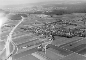
Härkingen covers an area of about 5.5 square kilometers (about 2.1 square miles). A big part of this land, more than half (51.6%), is used for agriculture, like growing crops. About 22% of the area is covered by forests. The rest of the land, about 27.6%, is where buildings and roads are located.
The town is in the Gäu district, situated in the Dünnern valley. It's located south of where the main A1 and A2 motorways meet.
Härkingen's Coat of Arms
The coat of arms for Härkingen has a special design. It shows a blue background with a golden oak tree stump. This stump has two branches with leaves and acorns. It grows from a green hill with three rounded bumps.
People and Population
Härkingen has a population of about 1,644 people. A small part of the population, about 11.7%, are people from other countries.
Most people in Härkingen speak German, which is about 92.4% of the population. Italian is the second most common language, followed by Albanian.
In 2008, there were slightly more men (51.8%) than women (48.2%) living in Härkingen. Many people living here were also born in Härkingen or somewhere else in Switzerland.
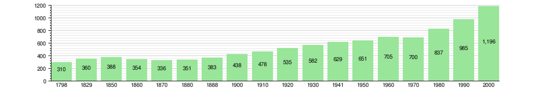
The population has grown over the years. You can see how the number of people has changed in the chart below:
Economy and Jobs
Härkingen has a low unemployment rate, which means most people who want to work can find jobs. In 2008, many people worked in different areas:
- Primary sector: This includes jobs like agriculture (farming). About 31 people worked in this area.
- Secondary sector: This involves manufacturing and construction. About 255 people had jobs here.
- Tertiary sector: This is the largest sector, with jobs in services. This includes things like sales, transportation, hotels, and healthcare. About 1,487 people worked in this sector.
Many people who live in other towns travel to Härkingen for work. About 2.8 workers come into Härkingen for every one worker who leaves to work elsewhere. Most people (64.4%) use a private car to get to work, while some (9.8%) use public transportation.
Religion in Härkingen
According to a survey in 2000, most people in Härkingen are Roman Catholic (60.2%). The next largest group belongs to the Swiss Reformed Church (21.1%). There are also smaller groups of people who follow other Christian faiths or Islam. About 12.2% of the population said they didn't belong to any church.
Education System
In Härkingen, many adults have completed higher levels of education. About 37% have finished upper secondary education, which is like high school. About 10.5% have gone on to university or a specialized college.
For younger students, the Canton of Solothurn's education system offers two years of optional Kindergarten. In the 2010-2011 school year, 19 children were in kindergarten. After that, students attend six years of primary school. In Härkingen, there were 76 students in primary school during that time.
For secondary school, students from Härkingen travel to a nearby town.
Transportation and Future Plans
Härkingen is an important location for transport. It is planned to be one of the main hubs for a new project called Cargo Sous Terrain. This project aims to create an underground system to transport goods. The first part of this system is expected to be ready by the early 2030s.
See also
 In Spanish: Härkingen para niños
