La Balize, Louisiana facts for kids
Quick facts for kids
La Balize
|
|
|---|---|

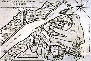
1744 French map of the Mississippi Delta East Pass, showing Fort de la Balize on the lower right
|
|
| Nickname(s):
Pilotsville
|
La Balize, Louisiana was a French fort and settlement. It was located near the mouth of the Mississippi River in what is now Plaquemines Parish, Louisiana. The village's name, also spelled La Balise, means "seamark". A seamark is a special sign that helps ships find their way.
La Balize was very important for controlling the river. It was rebuilt many times because of damage from hurricanes. The part of the river's mouth that is still active today is called the Balize Delta. It is named after this settlement. It is also known as the Birdfoot Delta because of its shape.
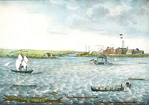
Most people living in La Balize were fishermen, river pilots, and their families. River pilots were crucial. They helped ships safely travel to and from the port of New Orleans. This was a tough job because the river's delta has many changing paths, strong currents, and sandbars. The village was often hit by hurricanes. In 1740, a hurricane washed it away. It was rebuilt on a new island called San Carlos. That village was also badly damaged many times and eventually destroyed.
By 1853, La Balize was also called Pilotsville. It was rebuilt about five miles (8 km) to the northwest. This new location was in the Southwest Pass. It was on the west bank of the Mississippi River. However, a hurricane on September 14–15, 1860, destroyed this village too. La Balize was then abandoned. A new pilots' settlement was built about five miles (8 km) upriver. It was on the east bank of the Mississippi, just above the Head of the Passes. This new village was named Pilottown.
History of La Balize
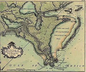
When explorer Robert de La Salle claimed this land for France in 1682, he saw how important this spot was. It was just above two main forks in the river. This meant whoever controlled it could control river travel. A map from about 1720 showed the Mississippi River's mouth with its different forks. It also showed the island and fort of La Balize. By 1721, the French had built a 62-foot (19 m) tall wooden pyramid as a la balize at the settlement. It stood quite high above the muddy delta wetlands.
By 1722, New Orleans became the main city of the French colony. In the early 1700s, the Roman Catholic Church quickly set up seven first parishes in Louisiana. One of these was at La Balize, started in 1722. The French also started four parishes in early villages in what are now Mississippi and Alabama. After La Balize was established, the King appointed Nicolas Godefroy Barbin as the chief administrator there. This appointment, signed in 1703, showed how important La Balize was for the French.
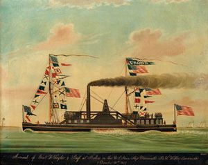
Even though the low-lying area was often hit by hurricanes, the French, and later the Spanish, needed to control the Mississippi's mouth. They also needed a place for pilots to meet ships. So, they always rebuilt the village. The tricky conditions at the Mississippi River's mouth meant ships needed river pilots. These pilots helped them cross the sandbar, deal with changing currents, and avoid getting stuck. After the Americans took control of the area in 1803 through the Louisiana Purchase, they sometimes called the village Pilotsville. When steam tugboats became common in the 1800s, pilots had more power to guide large ships in the river.
Challenges and Changes
Hurricanes were not the only problem for the settlements. Engineers also worked early on to make it easier for ships to enter the river. In 1726, French engineers used an iron harrow to drag through sandbanks. This helped ships pass the bar more easily. Pilots and captains also had to deal with changing river passages. The main path for ships changed four times before 1888. In 1750, the main path was at the Northeast Pass. Then it moved to Southeast Pass, then Southwest Pass, and finally South Pass. Today, the main ship passage is back in the Southwest Pass.
Historical records show the long struggle to keep this important site at the river's delta:
- 1740 – A hurricane destroyed La Balize. A new island, San Carlos, appeared, and the village was rebuilt there.
- October 7–10, 1778 – La Balize was destroyed again but rebuilt in the same spot.
- July 25–28, 1819 – Ships near La Balize faced a 24-hour storm. Only three ships got stuck.
- 1831 – La Balize suffered major damage.
- April 3–4, 1846 – This was a very damaging storm, similar to a hurricane. It created a new channel between Cat Island and its lighthouse.

- By 1853 – La Balize was moved to the Southwest Pass. It was built on the western bank, about five miles (8 km) northwest of its first spot.
- September 15–16, 1855 – At Cat Island, the lighthouse keeper's house was destroyed. The lighthouse was in danger. Almost everything else was washed away by the storm surge.
- August 11, 1860 – The first hurricane of the season hit. Trees were pulled up, and up to 10 feet (3 m) of water flooded the La Balize area.
- September 14–15, 1860 – The second hurricane struck the mouth of the Mississippi. It destroyed La Balize. Tides were six feet above the usual high-water mark. The village was abandoned and rebuilt upriver at what became Pilottown.
- October 2–3, 1860 – The third hurricane of the season caused widespread damage, even far inland in Baton Rouge.
- September 13, 1865 – La Balize had been abandoned since 1860. This hurricane destroyed the last parts of the village.
The hurricanes of 1860 convinced the pilots and their families to rebuild further upriver. They moved about five miles (8 km) away, to the east bank of the Mississippi. The new settlement was named Pilottown. At its busiest in the 1800s, it had about 800 people. A school for children operated there into the 1900s. Today, pilots usually stay there only for work shifts.
Very little of La Balize remains today. In the early 1900s, only a rusted iron tomb marked the site.
Travelers' Stories
Travelers found the Mississippi delta a surprising place. In her book Domestic Manners of the Americans (1833), Fanny Trollope wrote about her first views as her ship entered the river:
Large groups of pelicans stood on the mud banks. A pilot came to guide us over the sandbar, even before we could see land.
I had never seen a place so empty and sad as the entrance to the Mississippi. Only one thing stood above the swirling water: the mast of a ship that had sunk long ago. It was a sad reminder of past destruction and a warning of what might come.
Slowly, huge bulrushes appeared. A few more miles of mud brought us to a group of huts called the Balize. It was the most miserable place I had ever seen people live. But I was told many families of pilots and fishermen lived there.
Élisée Reclus, a young Frenchman who later became a famous geographer, wrote about his trip up the Mississippi in early 1853:
Thanks to the fast tugboat, we moved quickly. I put away my newspapers to watch the Southwest Pass, the main mouth of the Mississippi. Miles ahead, a long, thin black line seemed to stretch across the sea. Beyond this dark line, the river looked like a great white silk ribbon. Then came another black line, and farther away, the blue sea stretched to the horizon. The Mississippi looked like a canal going out to sea between two long walls. The 40 or 50 ships, with their tall masts, completed the scene.
Reclus also described his thoughts about the village of La Balize:
The village of Pilotsville, with its wooden shacks, is on the left bank of the Mississippi River. It is usually known as Balize. The real Balize was founded by French settlers on the southeast pass. But since the southwest pass became the main mouth of the Mississippi, the pilots moved their work and the name of their poor village there. There are few places in the world as sad and lonely as La Balize. The narrow strip of land where the houses are built is both the riverbank and the seashore. Saltwater waves and freshwater swells cover it in turns. They meet in a maze of ditches filled with a thick, dirty mix. Wherever the spongy ground bulges, wild canes and reeds grow in thick, tangled patches. The shacks are made of light planks so they don't sink in the wet ground. They are perched on high stilts, like birds on perches, to keep out moisture. When storms blow and sea waves crash into the river, the houses of La Balize could be swept away if they weren't tied down like ships. Sometimes, the whole village even drags on its anchors. Fevers and death constantly come from the bad air over La Balize. Yet, four hundred Americans bravely live in these shacks, hoping to make money from passing ships.
See also
 In Spanish: La Balize para niños
 | Leon Lynch |
 | Milton P. Webster |
 | Ferdinand Smith |


