La Cabrera facts for kids
Quick facts for kids
La Cabrera
|
|||
|---|---|---|---|
|
|||

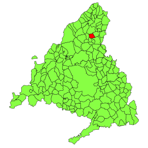
Municipal location within the Community of Madrid.
|
|||
| Country | |||
| Autonomous community | Community of Madrid | ||
| Area | |||
| • Total | 8.65 sq mi (22.40 km2) | ||
| Elevation | 3,366 ft (1,026 m) | ||
| Population
(2018)
|
|||
| • Total | 2,613 | ||
| • Density | 302.13/sq mi (116.65/km2) | ||
| Time zone | UTC+1 (CET) | ||
| • Summer (DST) | UTC+2 (CEST) | ||
La Cabrera (Spanish: [la kaˈβɾeɾa]) is a small town in central Spain. It is about 56 km (35 mi) away from Madrid, the capital city. La Cabrera is part of a larger area called the Sierra Norte de Madrid. This area is located within the Community of Madrid, which is one of Spain's self-governing regions.
The town covers an area of about 22.40 km2 (8.65 sq mi). It shares its borders with several other towns. To the north, it borders Lozoyuela-Navas-Sieteiglesias. El Berrueco is to the east, and Cabanillas de la Sierra and Torrelaguna are to the south. Valdemanco is also to the east.
A major road, European route E-05, passes through La Cabrera. This road used to be called N-I and connected Madrid all the way to Irun and France. Now, it is part of the A-1 highway.
Contents
Exploring La Cabrera's Mountains and Nature
La Cabrera is known for its beautiful mountains. The La Cabrera mountain range forms a natural boundary to the north of the town. The town itself is located in the eastern part of this mountain range. It sits at an elevation of about 1,038 m (3,406 ft) above sea level. Most of the mountain range is within La Cabrera. However, parts of it also extend into the nearby towns of Valdemanco and Lozoyuela.
What the Mountains are Made Of
The landscape here is made of a type of rock called granite. This granite formed a very long time ago, during the Palaeozoic era. The main features of this area include several high peaks. These are Cancho Gordo, which is 1,564 m (5,131 ft) tall, Pico del Miel, at 1,392 m (4,567 ft), and Cerro de La Cabeza, which is 1,247 m (4,091 ft) high.
Rivers and Streams
You can also find natural springs and streams in La Cabrera. One important stream is the Alfrecho stream. This stream eventually flows into the Jarama River.
Plants and Trees in La Cabrera
The southern slopes of the mountains are home to various trees and thick bushes. Some of the trees you might see include Pyrenean Oak, Holm Oak, Poplar, and Willow. You can also find Pink Rockrose, which is a type of flowering shrub.
Getting Around: Bus Routes
La Cabrera is connected to other towns and to Madrid by several bus routes. These buses make it easy for people to travel to and from the town.
- 191: Connects Buitrago to Madrid (Plaza de Castilla).
- 193: Travels from El Vellón to Pedrezuela and then to Madrid (Plaza de Castilla).
- 194: Goes from Rascafría to Madrid (Plaza de Castilla).
- 195: Connects Braojos to Madrid (Plaza de Castilla).
- 196: Runs from La Acebeda to Madrid (Plaza de Castilla), but only on weekends.
- 197B: Connects Torrelaguna to El Berrueco, La Cabrera, and Valdemanco.
- 197C: Travels from Torrelaguna to Venturada and Cabanillas.
- 725: Connects Valdemanco to Bustarviejo, Miraflores, and Madrid (Plaza de Castilla). This route has two trips per day.
See also
 In Spanish: La Cabrera (Madrid) para niños
 | William M. Jackson |
 | Juan E. Gilbert |
 | Neil deGrasse Tyson |


