
La Chapelle-aux-Chasses facts for kids
Quick facts for kids
La Chapelle-aux-Chasses
|
|
|---|---|

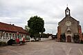
The town hall and church in La Chapelle-aux-Chasses
|
|

La Chapelle-aux-Chasses
Location in France

La Chapelle-aux-Chasses
Location in Auvergne-Rhône-Alpes
|
|
| Country | France |
| Region | Auvergne-Rhône-Alpes |
| Department | Allier |
| Arrondissement | Moulins |
| Canton | Dompierre-sur-Besbre |
| Intercommunality | Pays de Chevagnes en Sologne Bourbonnaise |
| Area
1
|
25.96 km2 (10.02 sq mi) |
| Population
(Jan. 2019)
|
201 |
| • Density | 7.743/km2 (20.05/sq mi) |
| Time zone | UTC+01:00 (CET) |
| • Summer (DST) | UTC+02:00 (CEST) |
| INSEE/Postal code |
03057 /03230
|
| Elevation | 207–251 m (679–823 ft) (avg. 227 m or 745 ft) |
| 1 French Land Register data, which excludes lakes, ponds, glaciers > 1 km2 (0.386 sq mi or 247 acres) and river estuaries. | |
La Chapelle-aux-Chasses is a small commune located in the Allier department in the central part of France. A commune is like a local town or village area that has its own local government.
This charming village is known for its quiet, rural setting. It is a place where people live and work, contributing to the larger region of Auvergne.
Contents
Where is La Chapelle-aux-Chasses?
La Chapelle-aux-Chasses is found in the Allier department. This department is in the Auvergne region of central France. It is part of the Moulins arrondissement. An arrondissement is a type of administrative division in France, similar to a district.
Nearby Areas
The commune is also part of the canton of Dompierre-sur-Besbre. A canton is another administrative area, often grouping several communes together.
People and Government
As of January 2019, about 201 people lived in La Chapelle-aux-Chasses. This makes it a very small community.
Local Leadership
The mayor of La Chapelle-aux-Chasses is Jean-Louis Guy. He was elected to serve from 2014 to 2020. The mayor is the head of the local government. They help manage the daily life of the commune. This includes things like local services and community projects.
Geography and Nature
La Chapelle-aux-Chasses covers an area of about 25.96 square kilometers. This is roughly 10 square miles. The land here is mostly flat or gently rolling.
Elevation
The elevation of the commune varies. The lowest point is 207 meters (about 679 feet) above sea level. The highest point reaches 251 meters (about 823 feet). The average elevation is around 227 meters (about 745 feet).
Images for kids
-
The town hall and church in La Chapelle-aux-Chasses
See also
 In Spanish: La Chapelle-aux-Chasses para niños
