La Luz, New Mexico facts for kids
Quick facts for kids
La Luz, New Mexico
|
|
|---|---|

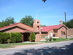
Our Lady of the Light Church
|
|

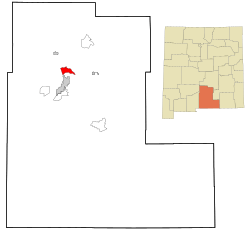
Location of La Luz, New Mexico
|
|
| Country | United States |
| State | New Mexico |
| County | Otero |
| Area | |
| • Total | 10.71 sq mi (27.74 km2) |
| • Land | 10.68 sq mi (27.67 km2) |
| • Water | 0.03 sq mi (0.07 km2) |
| Elevation | 4,721 ft (1,439 m) |
| Population
(2020)
|
|
| • Total | 1,578 |
| • Density | 147.70/sq mi (57.02/km2) |
| Time zone | UTC-7 (Mountain (MST)) |
| • Summer (DST) | UTC-6 (MDT) |
| ZIP code |
88337
|
| Area code(s) | Area code 575 |
| FIPS code | 35-38330 |
| GNIS feature ID | 2408506 |
La Luz is a small community in Otero County, New Mexico, United States. It is called a census-designated place (CDP) because it's a special area used for gathering population data. In 2020, about 1,578 people lived there.
La Luz is just north of Alamogordo. It sits on the eastern edge of the Tularosa Basin and near the Sacramento Mountains. Before 1848, La Luz was part of Mexico. Its name comes from the Spanish word for "light."
Contents
Exploring La Luz's Location
La Luz covers about 10.7 square miles (27.7 square kilometers) of land. It does not have any large bodies of water.
This community is located at the start of La Luz Canyon Creek. This creek's water comes from high up in the Sacramento Mountains. Both La Luz and the larger city of Alamogordo use water from La Luz and Fresnal creeks. They use a special system of ditches called acequias to move the water. Alamogordo has even built a big reservoir south of La Luz to store this water.
A Glimpse into La Luz's Past
Early Inhabitants and Spanish Arrival
For thousands of years, Native Americans lived in the area where La Luz is now. The Mescalero Apache people considered this region their homeland. It included the Sacramento Mountains and the Tularosa Basin. Today, the Mescalero Apache Reservation is about 30 miles northeast of La Luz.
There are different stories about when La Luz was first settled. Some say Franciscan friars founded it as early as the 1700s. They supposedly called it Nuestra Señora De La Luz, meaning "Our Lady of the Light." Old maps show this name, and La Luz Canyon might have been an early path through the Sacramento Mountains. This path could have connected to the Peñasco River.
Hispanic Settlers and the Railroad
It is known that many Hispanic settlers arrived around 1864. They came from villages near Socorro, New Mexico after big floods. These settlers founded the Village of Tularosa along the Tularosa Creek. They built a large acequia system for farming.
More Anglo settlers came after the American Civil War. Some started large ranches in the Tularosa Basin. These ranches supplied beef to nearby Fort Stanton. This led to conflicts, including the Lincoln County War.
The arrival of the railroad brought big changes. The railroad reached El Paso, Texas, in 1882. Charles B. Eddy and his partners built a branch line north from El Paso. They wanted to use the timber from the Sacramento Mountains and coal from further north. This led to the founding of Alamogordo in 1898, just south of La Luz. Eddy also built a mountain branch line through La Luz. This line climbed to about 9,000 feet in just a few miles. It was called the "Cloud Climbing Railroad" because it was an amazing engineering feat. The mountain part of the railroad was taken down in the early 1940s. The town of Cloudcroft was built in the Sacramento Mountains. It offered people from El Paso a cool escape in the summer. William Ashton Hawkins, Eddy's partner and lawyer, built a farm and a large home in La Luz that is still there today.
Rowland Hazard III and La Luz Pottery
In the early 1900s, Rowland Hazard III came to the area. He was from a wealthy family in Rhode Island. He started a big ranch and farm in the canyons above La Luz. He built the Coronado Lodge in Cottonwood Canyon in the early 1920s. It was a hunting lodge made from local stone.
Hazard also started the La Luz Pottery Works. This happened after he found rich clay in La Luz Canyon. The pottery works became famous for making clay roof tiles and other building parts. They also made very large pottery pots. The pottery works sold their products all over the country. This was during a time when the Spanish Colonial Revival style of architecture was very popular. Both the Coronado Lodge and the pottery works are great examples of this building style.
La Luz's Economy
The biggest employer nearby is Holloman Air Force Base. La Luz itself is mostly homes and farms. There is a small market on the road that connects the village to Highway 70.
La Luz is well-known for the many fruits grown there. These include figs, apricots, plums, and peaches. Apples, cherries, and pears grow in the higher areas of the canyons to the east. The surrounding area also has vineyards and pistachio groves. Many artists also live in the area.
Population and People
| Historical population | |||
|---|---|---|---|
| Census | Pop. | %± | |
| 2020 | 1,578 | — | |
| U.S. Decennial Census | |||
In 2000, there were 1,615 people living in La Luz. There were 648 households, and 463 of these were families. The average household had about 2.49 people.
About 84.71% of the people were White. About 10.40% were from other races. About 31.70% of the population identified as Hispanic or Latino.
The median age in La Luz was 39 years old. About 26.6% of the population was under 18 years old.
Learning in La Luz
La Luz is part of the Alamogordo Public Schools district. Children in the area go to La Luz Elementary School. For middle school, they attend Chaparral Middle School. Older students go to Alamogordo High School.
The La Luz School District joined the Alamogordo district on July 1, 1959.
See also
 In Spanish: La Luz (Nuevo México) para niños
 | Precious Adams |
 | Lauren Anderson |
 | Janet Collins |


