La Orchila Island facts for kids

La Orchila Island
|
|
|
La Orchila Island
|
|
| Geography | |
|---|---|
| Location | Caribbean Sea |
| Coordinates | 11°48′N 66°10′W / 11.800°N 66.167°W |
| Area | 43 km2 (17 sq mi) |
| Highest elevation | 139 m (456 ft) |
| Highest point | Cerro Walker |
| Administration | |
| Federal Dependencies of Venezuela | |
| Miranda Insular Territory | |
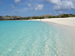
La Orchila Island is a special island off the coast of Venezuela, located north of Caracas. It's known for its many beautiful beaches, including one with amazing pink sand!
This island is also a military base. It has a special place where the Venezuelan president can stay. The homes for military families are mostly raised wooden houses. There's even a court for a game called bolas criollas. All the buildings are connected by smooth, clean paths.
Contents
Island History: A Look Back
Early Discoveries and Claims
A Spanish explorer named Alonzo de Santa Cruz wrote about La Orchila Island in the early 1500s. He called it "Orchilla." He said it was about eight leagues long and seven leagues wide. He also mentioned two smaller islands to its south. The name "Orchilla" came from a plant found there, similar to one in the Canary Islands.
In 1589, the Spanish Crown officially took control of La Orchila. This happened by order of the Spanish governor, Diego de Osorio. By the late 1500s, the island was considered part of the Province of Venezuela.
Dutch Interest and Disputes
In 1836, an author named M.D. Teenstra wrote about the island. He mentioned that the government of Curaçao, a Dutch island, also claimed La Orchila. However, he noted that La Orchila was not very important. This meant it wasn't worth fighting with Spain over.
The new country of Venezuela also said the island was theirs. Venezuelan coast guards often chased away fishermen from Curaçao. These fishermen came to La Orchila to collect shellfish, firewood, and birds' eggs. They also gathered hay and turtles.
Guano Mining and New Divisions
Around 1870, an American company started working on the island. This company, called Philadelphia Guano Company, collected and sold guano. Guano is a natural fertilizer made from bird droppings. They even built a factory, but it was later abandoned.
On August 22, 1871, La Orchila became part of the Colon Territory. This was a new administrative area created by General Antonio Guzmán Blanco. However, this territory was later dissolved.
Modern Era and Presidential Use
In 1938, La Orchila and other islands became part of the Federal Dependencies. This new division was created by law that same year. Until the 1950s, about 121 people lived on the island.
During the government of General Marcos Pérez Jiménez (1952–58), these residents were asked to leave. Under his rule, military buildings were constructed. About thirty small houses were also built. One of these was a special presidential residence. Many Venezuelan presidents used this residence as a summer home. This included former president Carlos Andrés Pérez.
In 1978, Venezuela and the Kingdom of the Netherlands set the sea borders. These borders were between Venezuela's Federal Dependencies and the Dutch Antilles in the Caribbean Sea.
Venezuelan President Hugo Chávez stayed on the island during a political event in April 2002.
In October 2011, La Orchila became part of the Francisco de Miranda Island Territory. This is a smaller part of the Federal Dependencies. Its capital is in the Los Roques Archipelago.
See also
 In Spanish: Isla La Orchila para niños
- Federal Dependencies of Venezuela
- List of marine molluscs of Venezuela
- List of sponges of Venezuela
 | Valerie Thomas |
 | Frederick McKinley Jones |
 | George Edward Alcorn Jr. |
 | Thomas Mensah |


