Lake Kapowsin facts for kids
Quick facts for kids Lake Kapowsin |
|
|---|---|
 |
|
| Location | Pierce County, Washington |
| Coordinates | 46°58′42″N 122°13′07″W / 46.97833°N 122.21861°W |
| Primary inflows | Ohop Creek |
| Primary outflows | Kapowsin Creek |
| Surface area | 512 acres (207 ha) |
| Average depth | 20–30 ft (6.1–9.1 m) |
| Max. depth | 30 ft (9.1 m) |
| Surface elevation | 584 ft (178 m) |
| Settlements |
|
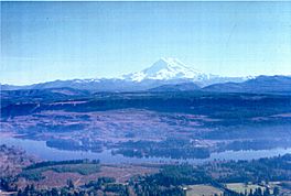
Lake Kapowsin is a beautiful lake located in Pierce County, Washington. It sits about halfway between the city of Tacoma on Puget Sound and the towering Mount Rainier in the Cascade Mountains. The lake is about 2.5 miles (4 km) long and 0.15 to 0.5 miles (0.24 to 0.8 km) wide. It covers an area of about 512 acres (207 hectares) and is generally shallow, with depths between 20 and 30 feet (6 to 9 meters). Its deepest point is about 30 feet (9 meters).
A small piece of land called Jaybird Island can be found in the northern part of the lake. Lake Kapowsin was formed in a very interesting way, shaped by ancient glaciers and a powerful mudflow from Mount Rainier.
How Lake Kapowsin Was Formed
Lake Kapowsin sits in a valley that was carved out by melting ice. This happened during the Pleistocene glaciation, also known as the Ice Age. A huge sheet of ice, called the Vashon glacier, melted and created this long, narrow channel.
About 550 years ago, a massive mudflow, called a lahar, rushed down from Mount Rainier. This particular mudflow is known as the Electron Mudflow. It was so powerful that it flowed into the valley where the lake now sits. Evidence of this event includes a "drowned forest" found underwater in the lake, which shows trees were covered by the mud.
The Electron Mudflow partially filled the channel, making its bottom smooth and shallow. It also blocked the natural path of Ohop Creek, which used to flow differently. This blockage caused the water to back up, forming the Lake Kapowsin we see today.
Getting Around the Lake
The Tacoma Rail shortline, which is a railway, runs along the western side of Lake Kapowsin. This railway is used for transporting goods.
Next to the railway, you'll find Orville Road. This road connects the town of Eatonville to the south with the town of Kapowsin to the north. Both the railway and the road offer views of the lake as they follow its western shore.
Fishing and Wildlife
Lake Kapowsin is a popular spot for fishing. It is home to several types of fish. The Washington Department of Fish and Wildlife regularly adds rainbow trout to the lake, making it a great place to catch them.
Fishing for rainbow trout is rated as "excellent" here. You can also find yellow perch in the lake, which are also considered "excellent" for fishing. This makes Lake Kapowsin a fun place for young anglers to try their luck and enjoy nature.
 | DeHart Hubbard |
 | Wilma Rudolph |
 | Jesse Owens |
 | Jackie Joyner-Kersee |
 | Major Taylor |


