
Lake Poorrarecup facts for kids
Quick facts for kids Lake Poorrarecup |
|
|---|---|

Lake Poorrarecup December 2018
|
|

Lake Poorrarecup
Location in Western Australia
|
|
| Location | Western Australia |
| Coordinates | 34°25′16″S 117°13′37″E / 34.42111°S 117.22694°E |
| Type | saline |
| Catchment area | 94 km2 (36 sq mi) |
| Basin countries | Australia |
| Max. length | 1.85 km (1.15 mi) |
| Max. width | 1.45 km (0.90 mi) |
| Surface area | 1.99 km2 (0.77 sq mi) |
| Average depth | 3 m (9.8 ft) maximum |
| Shore length1 | 5.1 km (3.2 mi) |
| Islands | none |
| 1 Shore length is not a well-defined measure. | |


Lake Poorrarecup, also called Poorarecup Lagoon, is a special kind of lake in Western Australia. It's a salt lake that sometimes dries up, which is what 'ephemeral' means. You can find it about 34 kilometers southwest of Cranbrook. It sits between the areas where the Kent River and Frankland River collect water.
Contents
About Lake Poorrarecup
Lake Poorrarecup used to be a freshwater lake. But by 1967, it became salty. This happened because many trees were cut down around the lake. Less rainfall also played a part.
The lake covers an area of about 1.99 square kilometers. When it's full, it can hold a lot of water. Its deepest point is about 3 meters. The land around the lake that collects water for it is called the catchment area. This area is about 94 square kilometers. However, only 59 square kilometers of this land drains directly into the lake. The rest flows into smaller lakes and swamps nearby. The lake itself is mostly round. It sits on a high area, about 225 meters above sea level. Over the last 20 years, the water has been quite salty.
The lake gets its water from rain and from underground water. It is surrounded by a special natural area. This area acts like a buffer zone, protecting the wetland.
The Land Around the Lake
The land around Lake Poorrarecup is mostly flat or gently rolling. There are not many clear rivers or streams flowing into it. Other lakes nearby include Lake Matilda and Lake Balicup.
The ground in this whole area is made of old sediments. These layers of earth sit on top of very old rocks. The low hills often have a hard, iron-rich cap called laterite. You might also see sandy ridges, which were once ancient sand dunes. These dunes usually run alongside the lake.
Between 1973 and 2001, the lake received about 2.65 billion liters of water each year. About 78% of this water evaporated. The good news is that the lake has not dried up or overflowed in the last two decades.
Plants Around the Lake
Sadly, about half of the natural forests in this area have been cleared. This was done to make space for farms. The native plants that remain are mostly jarrah trees. You can find jarrah woodlands mixed with wandoo and swamp yate trees. These grow in higher, sandy areas.
In the wider, swampy parts, you'll see paperbark trees. There are also different types of Banksia plants. Sedge swamps are common here too. Sandy flat areas have woodlands with jarrah, marri, wandoo, and swamp yate trees.
Inside the lake, you can find a type of seagrass called Ruppia megacarpa. You might also see piles of dried seagrass, called wrack, along the shoreline.
History of Lake Poorrarecup

The Noongar people are the traditional owners of this land. They have lived in this region for thousands of years.
Settlers started arriving in the late 1800s. By the 1920s, large cattle farms were set up in the area.
In 1959, changing rooms for women and a playground were built near the lake. A small shop, called a kiosk, was added in 1961. People used to have big picnics at the lake on New Year's Day. In 1963, over 2,500 people came to celebrate!
In 1967, a type of fish called Red perch were put into the lake. The Doris Haynes Memorial Park, which surrounds part of the lake, opened in 1975. A wall was also built by the Junior Farmer's Club that same year. Fishing was allowed. However, by 1977, the red perch were gone. This was because the lake water had become too salty for them. In November 1999, scientists started checking the water quality regularly.
In 2007, a group called the Lake Poorrarecup Upgrade Committee was formed. They improved the boat ramp. They also installed new eco-friendly toilets.
Lake Poorrarecup is the biggest of over a hundred lakes and swamps in the Shire of Cranbrook. It's a popular spot for fun activities during warmer months. People come here for swimming and water skiing. The area has changing rooms, parking, shaded spots, and toilets. You can also camp around the lake. Camping costs A$20 per vehicle per night.
Images for kids
-
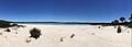
Lake Poorrarecup December 2018
